Rivermap
HomeThe Map
List View
Befahrbarkeit
English Summary
Karte Einbetten
Systemstatus
Kontakt und Team
Datenlieferanten
Contributor Agreement
The RCSD
Public licenses
Rivermap Japan
![]() "Rivermap Supporter" Group
"Rivermap Supporter" Group
Flusshinweise
Als Grundlage dient wenn immer möglich ein Flussführer.
Seite: 1 2 3 4 5 . . . 11 12 13 14 15 16 17 . . . 267 268 269
Resultate 261 - 280 von 5371
Setninga (NO), Sjøll - Mogrenda
Info
done in august 2025. after 2 days of rain the gauge at Atna was at 24m3s. the level at Setninga was approx 10m3s.
what a nice little river. it starts in a beautiful lake. here and the first kilometers the terrain is open. but it will gradually dig deeper into the valley. most of the time, you are far away from the road.
the first 2km are easy class II. then, at the second bridge, comes the first rapid which is more committing. you better hold the line, or you will be pushed into an undercut.
the following 6km are the most interesting. usually the river is about 15m wide. but when it gets narrow (like 3m), the rapids get pushier IV- and follow quickly after another, sometimes close to walls you want to stay away from.
then the river gets gradually calmer again, until in the last 2km there will be some more III+ rapids. the final rapid, at the takeout bridge, is quite heavy and does not represent the character of the section well. it can easily be portaged on river right.
for those who want to shuttle with their bike: it is not as bad as it looks. the road does climb long, but does so in a moderate angle and the asphalt is in good condition.
 • #6800 • 08.08.2025 11:51
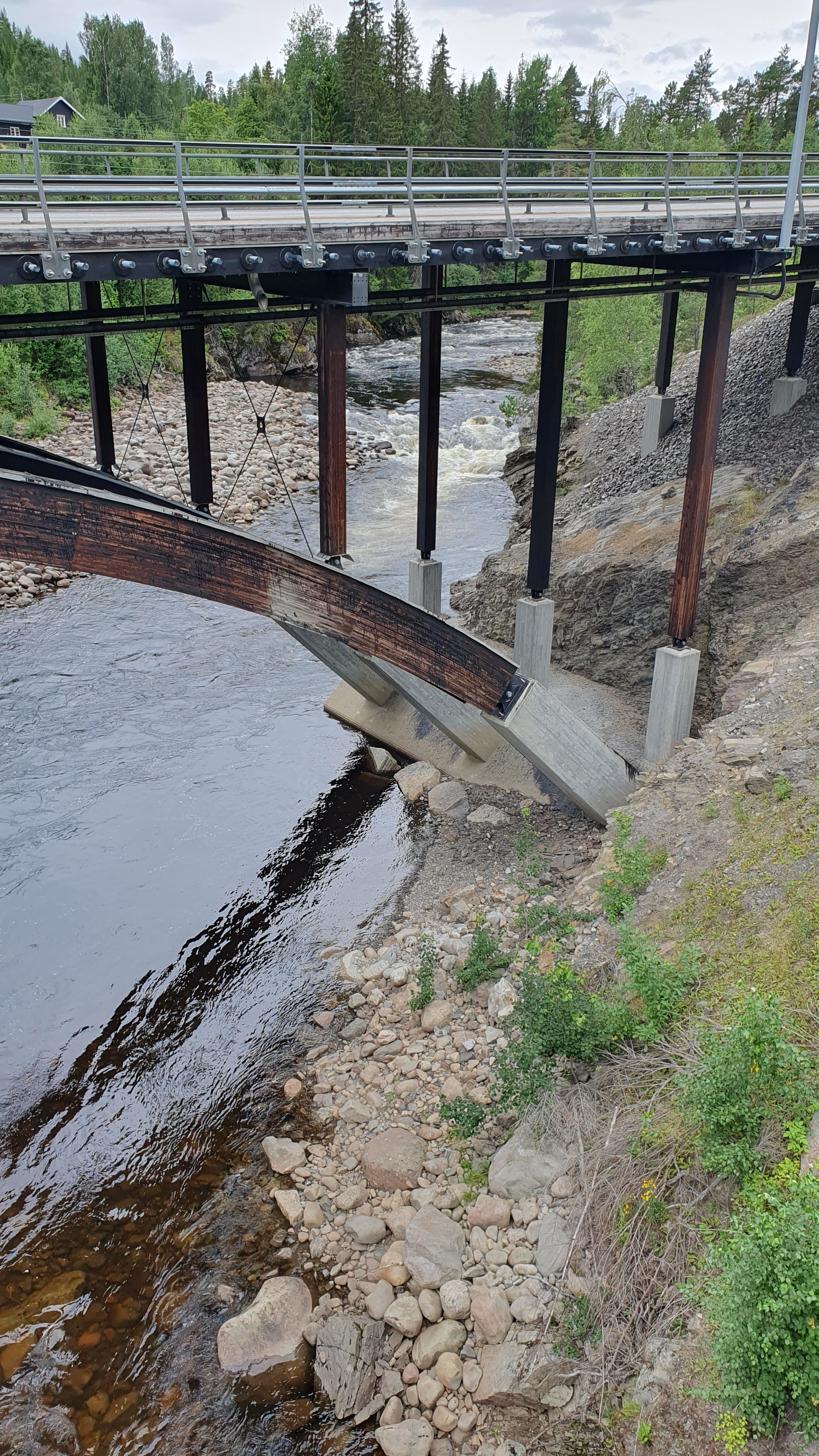
Åsta (NO), Holmbua - Åsta
Info
this picture is from the bridge at takeout. watch the concrete fundament. the water is 10cm below the edge (in the middle of some small round reprints). this is a good level for a first run. the four IV- rapids can be run on sight (when you are capable of quick reaction and some powerful strokes).
below that level, the class III gravel rapids will become a bit scratchy. above, you better stop for some scouting as soon as you see bedrock aproaching ...
below that level, the class III gravel rapids will become a bit scratchy. above, you better stop for some scouting as soon as you see bedrock aproaching ...
 • #6799 • 08.08.2025 11:50
Åsta (NO), Holmbua - Åsta
Info
done in july 2025. the gauge was showing 14m3s, but it was after a day of rain, so probably a bit more.
this river is great. starting at Astvollen (the lower, more interresting 8km) it is mostly gravel rapids in class III. but there are 4 or 5 rapids in bedrock, and they are quite powerful IV-, even at this low level. the last one is a 2m fall - but you can run a chickenline on the right.
for shuttle, use the road on river left.
• #6798 • 08.08.2025 11:47Gløta (NO), Rystallbakken - Gløtberget
Info
done in july 2025. the gauge was showing 35m3s.
this section connects two lakes and is only 2km long. you start in the first lake and have to paddle 300m for the fun to begin. there are 5 or 6 gravel rapids and longer, flat stretches between. nothing exceeds class III. at the end, there is again 200m to go on a lake to reach the takeout.
this section connects two lakes and is only 2km long. you start in the first lake and have to paddle 300m for the fun to begin. there are 5 or 6 gravel rapids and longer, flat stretches between. nothing exceeds class III. at the end, there is again 200m to go on a lake to reach the takeout.
• #6797 • 08.08.2025 11:46Imsa (NO), Upper (Søndre Imssjøen - )
Info
Entering the valley from the top costs 150 NOK and leads down a 20km gravel road.
And there is an additional toll station right in the middle of this section, so every run will cost you.
And there is an additional toll station right in the middle of this section, so every run will cost you.
• #6795 • 08.08.2025 11:36Inn (CH), Giarsun
Divers
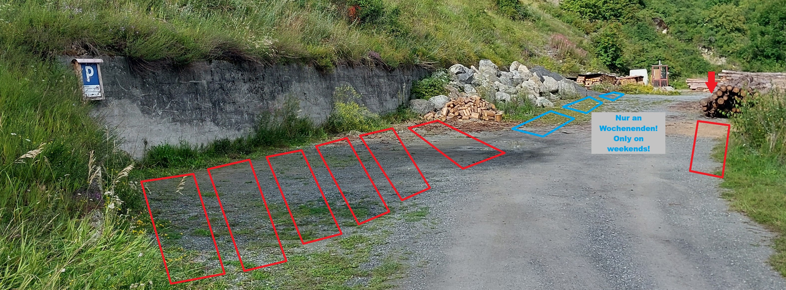
Ergänzung Parkordnung auf dem neuen Parkplatz beim Ausstieg Giarsun
(wichtig, falls du an gut besuchten Wochenenden beim Ausstieg unten an Ardez aussteigst)
Mit dem Werkdienst der Gemeinde Scuol haben wir folgende Parkordnung besprochen:
- 5 bis 6 Autos senkrecht zur Wand auf der linken Seite beim P-Schild
- 2 bis 3 Autos in den Lücken zwischen den Holzbeigen auf der rechten Seite
- nur an Wochenenden(!): 2 bis 3 Autos auf der linken Seite entlang dem Stein- und Kieshaufen
(an Werktagen darf der Zugang dazu nicht versperrt werden.
Falls alles voll ist, kann man 300m weiter oben vor dem Gebäude "Sarinera Ardez" (ARA) parkieren.
 • #6794 • 08.08.2025 07:06
Setninga (NO), Sjøll - Mogrenda
Ca. 200m vor der Kernstelle Baum , rechts vorsichtig umfahrbar . Atna Pegel lag bei 38 cbm was für die Setninga auf keinen Fall zu viel war . Eine wunderschöne Fahrt am 7.8.25
• #6792 • 07.08.2025 18:16Mistra (NO), Gorge (Renåskarven - Misteregga)
Info
These are the coordinates of the parking spot at put-in:
61.730307,11.328337
61.730307,11.328337
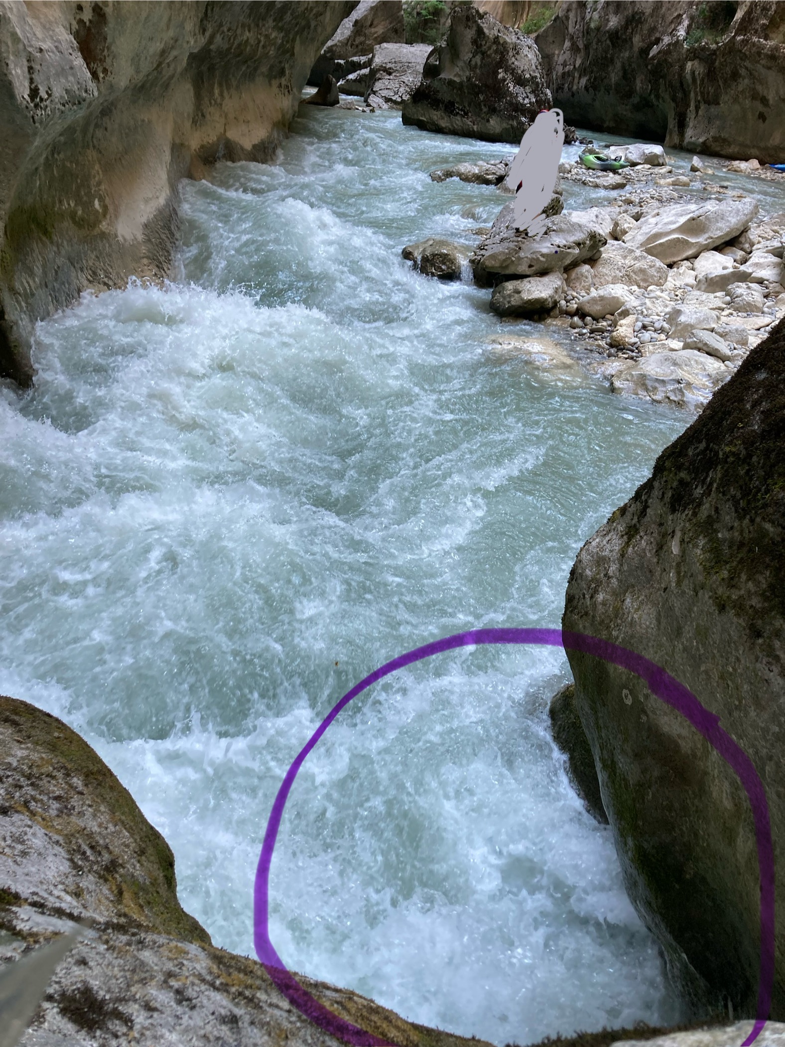
• #6789 • 07.08.2025 16:43Verdon (FR), Grand Canyon (Point Sublime - Lac de Sainte Croix)
Dangerous Siphon just before L‘Imbut!!! (see entry #6787)
")
 • #6788 • 06.08.2025 22:56
Verdon (FR), Grand Canyon (Point Sublime - Lac de Sainte Croix)
Caution at the entry rapid of L‘Imbut!!!
Dangerous siphon in the left pocket of the rock. Kayaker disappeared for a long time and only resurfaced about 10 meters inside the Imbut. The kayak itself also totally gut sucked under water and only was found the day after without the dam release.
Put-In after the rock is manageable. Take care and scout carefully!
• #6787 • 06.08.2025 20:26Hornbach (AT), Unterer
Paddled yesterday at 7,5 qm/s from Sackkapelle. Water was enough, should not be lower (a bit scratchy in the gravel field). First major rapid 1km after put in blocked by trees. Portage is possible (no ropes needed).
Matthias (Kanuschule Obermain)
Matthias (Kanuschule Obermain)
 • #6786 • 04.08.2025 17:24
Albula (CH), Waldschlucht
Befahrbarkeit
Mitteilung der Kantonspolizei GR/Hartmann) von heute 3. August 2025. Betrifft drohender Bergsturz in Briez. Ab sofort ist die Waldschlucht (Surava bis Tiefencastel) wieder, bis auf weiteres, befahrbar.
• #6785 • 03.08.2025 13:50Thur (CH), Oberste (Starkenbach - Stein)
Einfahrt Schlucht mit Bäumen verstopft. Foto bei knapp unter HW-Marke...
 • #6784 • 02.08.2025 15:41
Saalach (AT), Lofer-Schlucht
S Turn Blocked
 • #6782 • 01.08.2025 15:54
Strubbach (Loferbach) (AT),
Befahrbarkeit
Done yesterday with 180cm. Every line was clean after the last flood, but two trees that could potentially come into play. They are in the following 200m after the portage/weir out of the main flow.
Cheers Max
Cheers Max
• #6780 • 31.07.2025 09:57Saane / Sarine (CH), Saanen - Camping Le Berceau
Gefahr aufgehoben
Befahren am 30.07.2025 bei ca. 40cm
Keine Bäume in der Schlucht
Keine Bäume in der Schlucht
• #6779 • 30.07.2025 22:35Erlauf (AT), Vordere Tormäuer (Standardstrecke)
Befahrbarkeit
Nach dem hohen Wasserstand von 36m3 am 27.07 war am 30.07 bei 13m3 alles frei, bis auf einen Baum der rechtzeitig über die Kiesbank auf der rechten Seite umtragen werden kann. Bei 250cm ist er noch gut zu überfahren.
• #6777 • 30.07.2025 18:10Ulvåa (NO), Upper (Tunga - Kabben)
Divers
I left a woolen sweater at the end of the slide on Ulvaa on the right side. If anyone finds it, please reach out via email dominika.opalka@gmail.com or whatsapp +48504667684
• #6774 • 26.07.2025 20:06Sjoa (NO), Åsengjuvet
Urnäsch (CH), Obere Urnäschschlucht (Zürchersmühle - Hundwiler Brücke)
Leider gab es einen Erdrutsch und ein grosser Fels ist in den ersten Drop im Schluchteingang gefallen. Zusätzlich hängt dort aktuell auch ein Ast. Aktuell unfahrbar.
Nach dem mittleren Drop der Schlucht hängt ebenfalls ein neuer Baum. Man kommt sehr gut dran vorbei/drunter durch, nur die Äste, die ins Wasser ragen sind etwas blöd.
Nach dem mittleren Drop der Schlucht hängt ebenfalls ein neuer Baum. Man kommt sehr gut dran vorbei/drunter durch, nur die Äste, die ins Wasser ragen sind etwas blöd.

 • #6771 • 21.07.2025 23:23
Seite: 1 2 3 4 5 . . . 11 12 13 14 15 16 17 . . . 267 268 269
nach oben