Rivermap
HomeThe Map
List View
Befahrbarkeit
English Summary
Karte Einbetten
Systemstatus
Kontakt und Team
Datenlieferanten
Contributor Agreement
The RCSD
Public licenses
Rivermap Japan
![]() "Rivermap Supporter" Group
"Rivermap Supporter" Group
Flusshinweise
Als Grundlage dient wenn immer möglich ein Flussführer.
Verdon: Grand Canyon (Point Sublime - Lac de Sainte Croix)
IV-V (X) 0 km
Resultate 1 - 20 von 20
Gefahr aufgehoben
Imbut pas plus bouché que d'habitude
 • #7332 • 27.05.2026 16:07
Flash!
Blue Waka Skuxx is still missing after the accident on tuesday 05/08/2025 - we‘ve been told that the kayak was found the next day at low water without the dam release and placed on the shore. Unfortunately, by the following friday, it could no longer be found there.
If you happen to spot anything in the river or know of someone who has recovered the kayak, we’d be very grateful if you could let us know. The kayak has both the phone number and the name written inside.
Please stay safe and take care out there.
If you happen to spot anything in the river or know of someone who has recovered the kayak, we’d be very grateful if you could let us know. The kayak has both the phone number and the name written inside.
Please stay safe and take care out there.
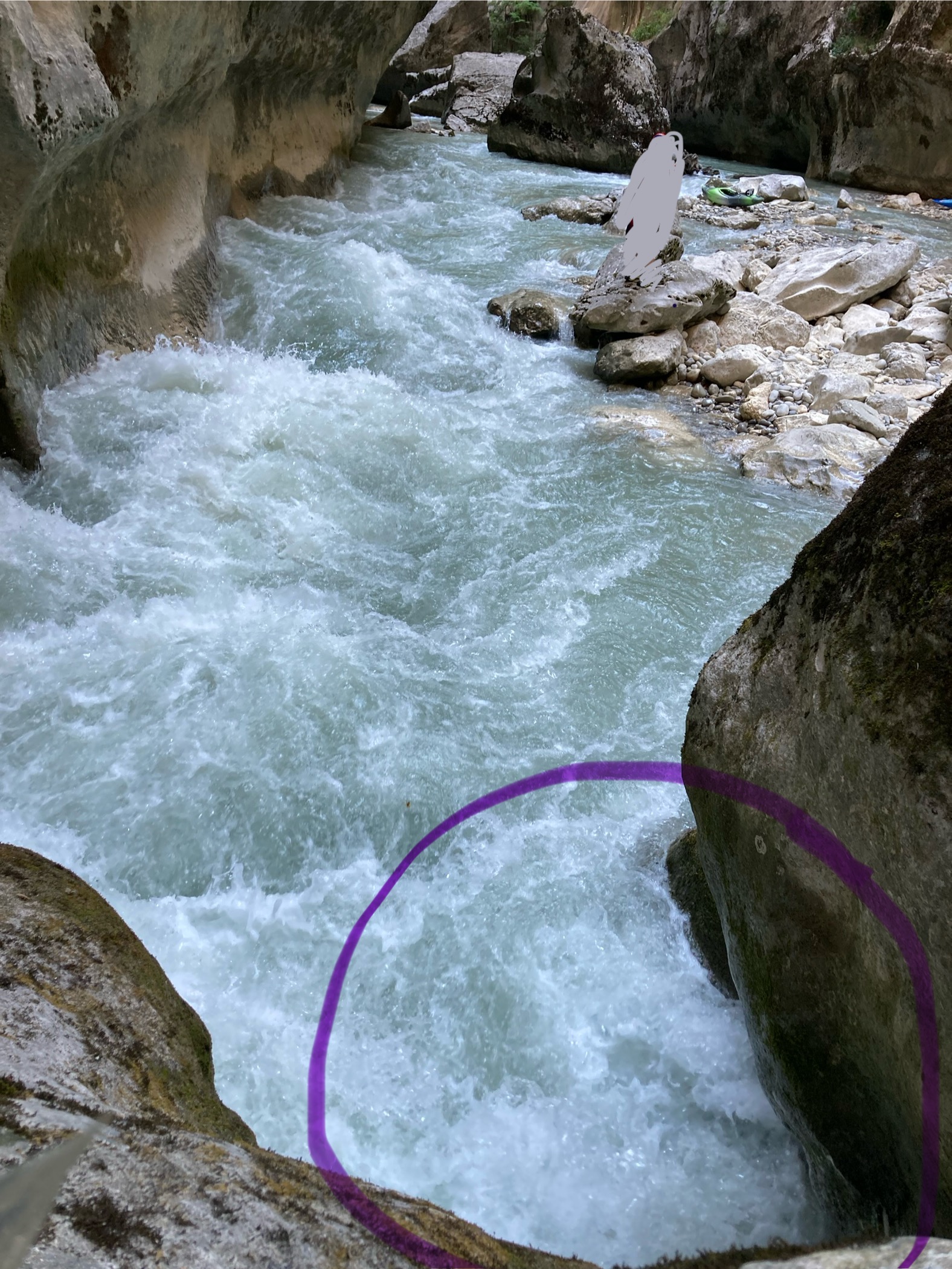
• #6805 • 12.08.2025 09:07Dangerous Siphon just before L‘Imbut!!! (see entry #6787)
")
 • #6788 • 06.08.2025 22:56
Caution at the entry rapid of L‘Imbut!!!
Dangerous siphon in the left pocket of the rock. Kayaker disappeared for a long time and only resurfaced about 10 meters inside the Imbut. The kayak itself also totally gut sucked under water and only was found the day after without the dam release.
Put-In after the rock is manageable. Take care and scout carefully!
• #6787 • 06.08.2025 20:26Info
in July/August Tuesday is a guaranteed day when EDF releases water (typ. 10-13m3/s = low but no rock contact). Friday is NOT guaranteed anymore as it was in the past. Check with the local raft companies to find out if Friday or maybe another day gets a release in that week.
• #6763 • 16.07.2025 22:48Befahrbarkeit
ran 12.7.25. except after couloir Samson no trees in the lines. L'imbut is good to go. we had 13m3/s.
• #6762 • 16.07.2025 22:43Trees accross the river shortly after Couloir Samson at the end of a pool. well visible, easy to portage on the right. ran on 12.7.2025
• #6761 • 16.07.2025 22:38Bewertung NW-MW-HW
be 10 me 25 he 40
• #3946 • 03.10.2020 02:01Info
• #2653 • 27.11.2017 15:04Info
• #2550 • 31.07.2017 14:22Info
Video :
https://www.youtube.com/watch?v=OxIt-zRq-tY
Better to go with somebody who knows the section, because there are many siphons.
Wonderful landscape, one of the nicest in Europe
https://www.youtube.com/watch?v=OxIt-zRq-tY
Better to go with somebody who knows the section, because there are many siphons.
Wonderful landscape, one of the nicest in Europe
• #2522 • 13.07.2017 21:22Siphon in einer niederen Felsenklamm (kurz nach der Felsenloch-Stelle)

 • #1062 • 06.05.2012 14:53
Durchfahrt durch enges Felsenloch (einige Stellen nach L'Imbut). Bei NW kein Problem, bei >MW kann es ein Siphon werden.
 • #1061 • 06.05.2012 14:50
Die abgrenzende Wand der grossen Halbhöhle mit der Doppel-Eingangsstufe beim Styx ist stark unterspült, unbedingt sichern


 • #1060 • 06.05.2012 14:45
Holzstämme im Eingang des L'Imbut. Die Strömung ist im Eingang schwach und es kann bei NW zurückgepaddelt werden falls kein Durchkommen, sofern noch jemand am Ufer mit einem Wurfsack steht und einem ans Ufer hochziehen kann.


 • #1059 • 06.05.2012 14:43
Die Einfahrt zum l'Imbut (nach Styx) besitzt links einen unterspülten Felsen.


 • #1058 • 06.05.2012 14:35
viele Siphone, bei Sommerablass gut sichtbar und einfach zu umfahren, solides Beherrschen von WW IV- vorausgesetzt
• #1056 • 06.05.2012 14:16Info
• #1010 • 06.05.2012 13:00Bewertung NW-MW-HW
Pegel visuel
NW = 10 m3/s
MW = 20 m3/s
HW = 40 m3/s
Im Sommer: Ablass Di und Fr ca. 10-13cms
http://www.rafting-castellane.com/lachers_edf_verdon.html
http://www.aboard-rafting.com/GB/news/news.html
NW = 10 m3/s
MW = 20 m3/s
HW = 40 m3/s
Im Sommer: Ablass Di und Fr ca. 10-13cms
http://www.rafting-castellane.com/lachers_edf_verdon.html
http://www.aboard-rafting.com/GB/news/news.html
• #1009 • 06.05.2012 12:59