Rivermap
HomeThe Map
List View
Befahrbarkeit
English Summary
Karte Einbetten
Systemstatus
Kontakt und Team
Datenlieferanten
Contributor Agreement
The RCSD
Public licenses
Rivermap Japan
![]() "Rivermap Supporter" Group
"Rivermap Supporter" Group
Flusshinweise
Als Grundlage dient wenn immer möglich ein Flussführer.
Seite: 1 2 3 4 5 . . . 267 268 269
Resultate 1 - 20 von 5370
Chéran (FR), Pont de l'Abime - Alby
Nom (FR), Plan du Bourgeal - Thônes
Wilde Gutach (DE), Obere (Waldschlucht: Hexenlochmühle - Kraftwerk)
Info
Hier ein Video einer durchgängigen Befahrung mit 120cm im späten Oktober 2025. Alle interessanten Stellen sind in den Kommentaren mit Zeitstempeln markiert.
https://youtu.be/lcEOUHv2ouc?si=QQuBgRoeQssth5hD
https://youtu.be/lcEOUHv2ouc?si=QQuBgRoeQssth5hD
 • #7106 • 09.12.2025 17:25
Wilde Gutach (DE), Untere (Kraftwerk - Simonswald)
Info
Hier ein Video einer durchgängigen Befahrung mit 120cm im späten Oktober 2025. Alle interessanten Stellen sind in den Kommentaren mit Zeitstempeln markiert.
https://youtu.be/lcEOUHv2ouc?si=QQuBgRoeQssth5hD
https://youtu.be/lcEOUHv2ouc?si=QQuBgRoeQssth5hD
• #7105 • 09.12.2025 17:22Kössener Ache (AT), Entenlochklamm
Thierseer Ache (AT), Landl - Gasthaus Wachtl
Info
Webcam beim Pegel: https://webcams.hnd.bayern.de/ro/Kieferbach/webcam.jpg
• #7101 • 09.12.2025 17:13Mangfall (AT), Maxlmühle - Westerham
Info
Webcam beim Pegel: https://webcams.hnd.bayern.de/ro/Valley-Mangfall/webcam.jpg
• #7100 • 09.12.2025 17:02Wilde Gutach (DE), Obere (Waldschlucht: Hexenlochmühle - Kraftwerk)
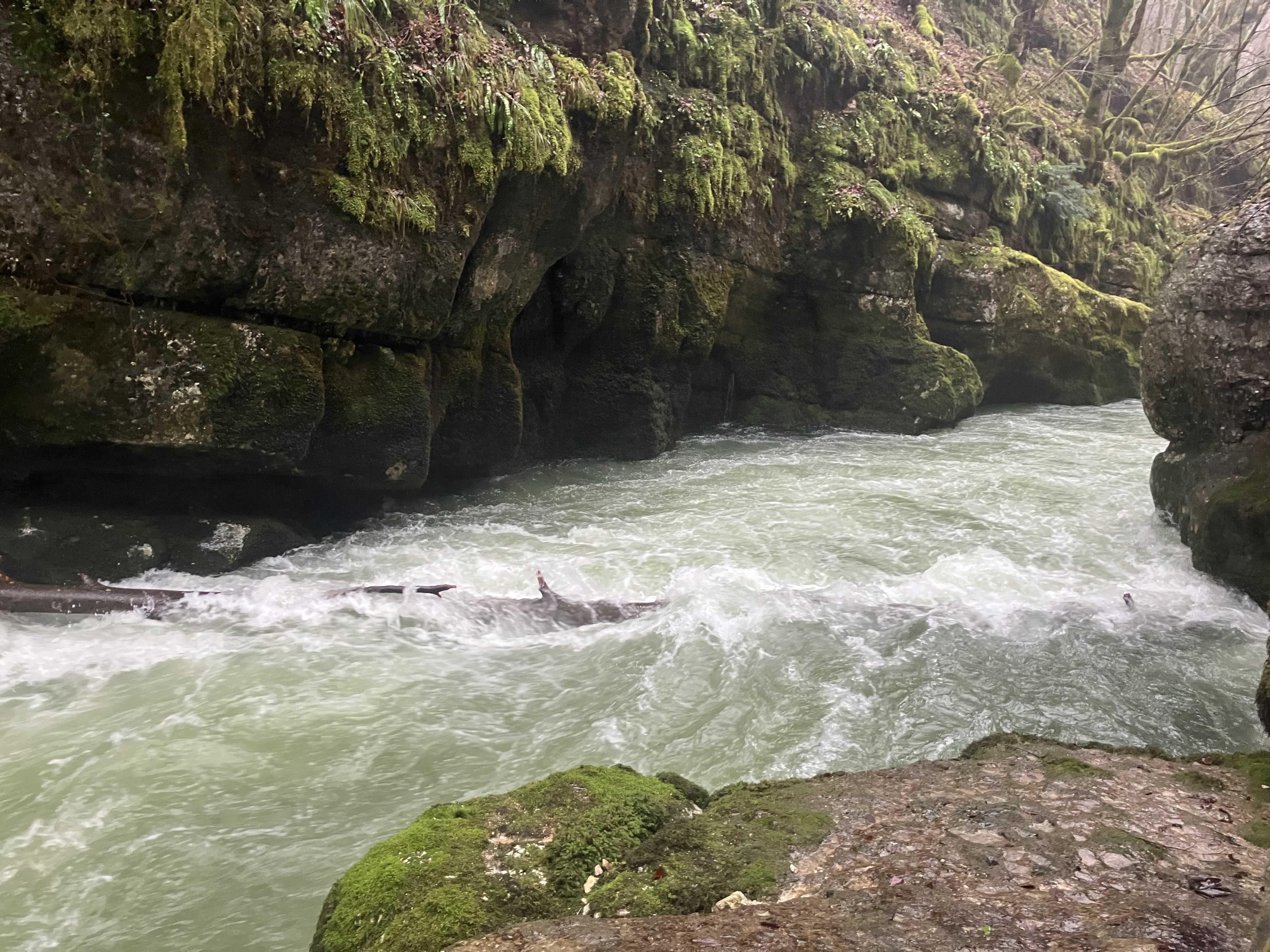
Obacht mit Bäumen!
Zwischen Sägewerkkatarakt bis Waldschlucht ging's am 8.12.2026 bei 95cm gut. Nach Eingang Waldschlucht, kurz nach den ersten "Wasserfällen", einiges Holz drin. Besser umtragen, bzw. gut scouten. Mussten Tour wg. Paddelverlust an Baum mit scheinbar freier Durchfahrt abbrechen. Ich gehe die nächsten Tage ggf. wieder sägen, damit die Waldschlucht wieder sicher fahrbar wird. Wenn Gefahr beseitigt, nehme ich den Hinweis wieder raus.
Zwischen Sägewerkkatarakt bis Waldschlucht ging's am 8.12.2026 bei 95cm gut. Nach Eingang Waldschlucht, kurz nach den ersten "Wasserfällen", einiges Holz drin. Besser umtragen, bzw. gut scouten. Mussten Tour wg. Paddelverlust an Baum mit scheinbar freier Durchfahrt abbrechen. Ich gehe die nächsten Tage ggf. wieder sägen, damit die Waldschlucht wieder sicher fahrbar wird. Wenn Gefahr beseitigt, nehme ich den Hinweis wieder raus.

 • #7099 • 09.12.2025 10:05
Loisach (AT), Griesenschlucht
Befahrbarkeit
Paar neue Bäume sind im Bach. Bei der Anfangsrapid ist in der rechten Linie ein Baum. Links geht einwandfrei. Später immer wieder Zeichen eines Waldbaches.
• #7097 • 08.12.2025 21:16Bienne (FR), Usine hydroélectrique de Tancua - La Rixouse
Correction to the post below (#7090). While the tree from the post #6346 and end of video #6382 is still in, the tree #7090 is new and below the first one. It blocks the gorge exit just below the seal launch at 6:28 min in the video #6382. Blockage might be complete at low to medium flows and running is still sketchy at ~10-11 cms. Take care!
• #7096 • 08.12.2025 19:45Lonza (CH), Minigolf Wiler - Stausee
Fahrverbot
Der Aufenthalt an der Lonza ist wieder erlaubt gemäss Information auf kippel.ch. Es kann aber zukünftig wieder zu Sperrungen kommen, je nachdem wie sich die Lage im Bergsturzgebiet oberhalb des Abschnittes entwickelt.
• #7095 • 08.12.2025 09:34Lonza (CH), Minigolf Wiler - Stausee
Bewertung NW-MW-HW
Die Messstation in Blatten wurde durch den Bergsturtz vom 28.5.2025 zerstört.
• #7094 • 08.12.2025 09:16Lonza (CH), Fafleralp - Kühmad
Fahrverbot
Die Gemeinde Blatten (bis hoch zur Fafleralp) befindet sich in einer Sperrzone. In dieser sind nur gewisse Wanderwege wieder freigegeben. Für alle anderen Bereich wird eine Spezialgenehmigung benötigt. Infos hier: https://www.blatten-vs.ch/?action=get_file&id=18&resource_link_id=53c
• #7093 • 08.12.2025 09:10Lonza (CH), Kühmad - Minigolf Wiler
Fahrverbot
Die Gemeinde Blatten (bis hoch zur Fafleralp) befindet sich in einer Sperrzone. In dieser sind nur gewisse Wanderwege wieder freigegeben. Für alle anderen Bereich wird eine Spezialgenehmigung benötigt. Infos hier: https://www.blatten-vs.ch/?action=get_file&id=18&resource_link_id=53c
• #7092 • 08.12.2025 09:09Lonza (CH), Kühmad - Minigolf Wiler
Befahrbarkeit
Seit dem Bergsturz vom 28.5.2025 ist diese Strecke nicht mehr befahrbar.
• #7091 • 08.12.2025 09:04Bienne (FR), Usine hydroélectrique de Tancua - La Rixouse
The tree from comment 6346 is still there. Photo is at 11 cms
 • #7090 • 07.12.2025 23:02
Subersach (AT), Wasserhölzer (Sibratsgfäll - Lingenau)
Isel (AT), PreKaterakt
Lutzbach (AT), Oberer
Litzbach (AT), Standardstrecke (Silbertal - Hölle)
Seite: 1 2 3 4 5 . . . 267 268 269
nach oben