Rivermap
HomeThe Map
List View
Befahrbarkeit
English Summary
Karte Einbetten
Systemstatus
Kontakt und Team
Datenlieferanten
Contributor Agreement
The RCSD
Public licenses
Rivermap Japan
![]() "Rivermap Supporter" Group
"Rivermap Supporter" Group
Flusshinweise
Als Grundlage dient wenn immer möglich ein Flussführer.
Seite: 1 2 3 4 5 . . . 62 63 64 65 66 67 68 . . . 267 268 269
Resultate 1281 - 1300 von 5371
Ötztaler Ache (AT), Köfelser Strecke (Brücke - Umhausen)
Befahrbarkeit
Befahren am 3.9.23 (nach Hochwasser) bei 230 cm.
Strecke recht verändert. Knifflige Walzenkombination gleich zum Start und dann wieder etwa in der Streckenmitte in einer langen Rechtskurve. Kein Holz
Strecke recht verändert. Knifflige Walzenkombination gleich zum Start und dann wieder etwa in der Streckenmitte in einer langen Rechtskurve. Kein Holz

 • #5494 • 03.09.2023 13:51
Glenner (CH), Peiden - Ilanz
Baum quer im Fluss kurz hinter dem Wehr, rechts um tragen
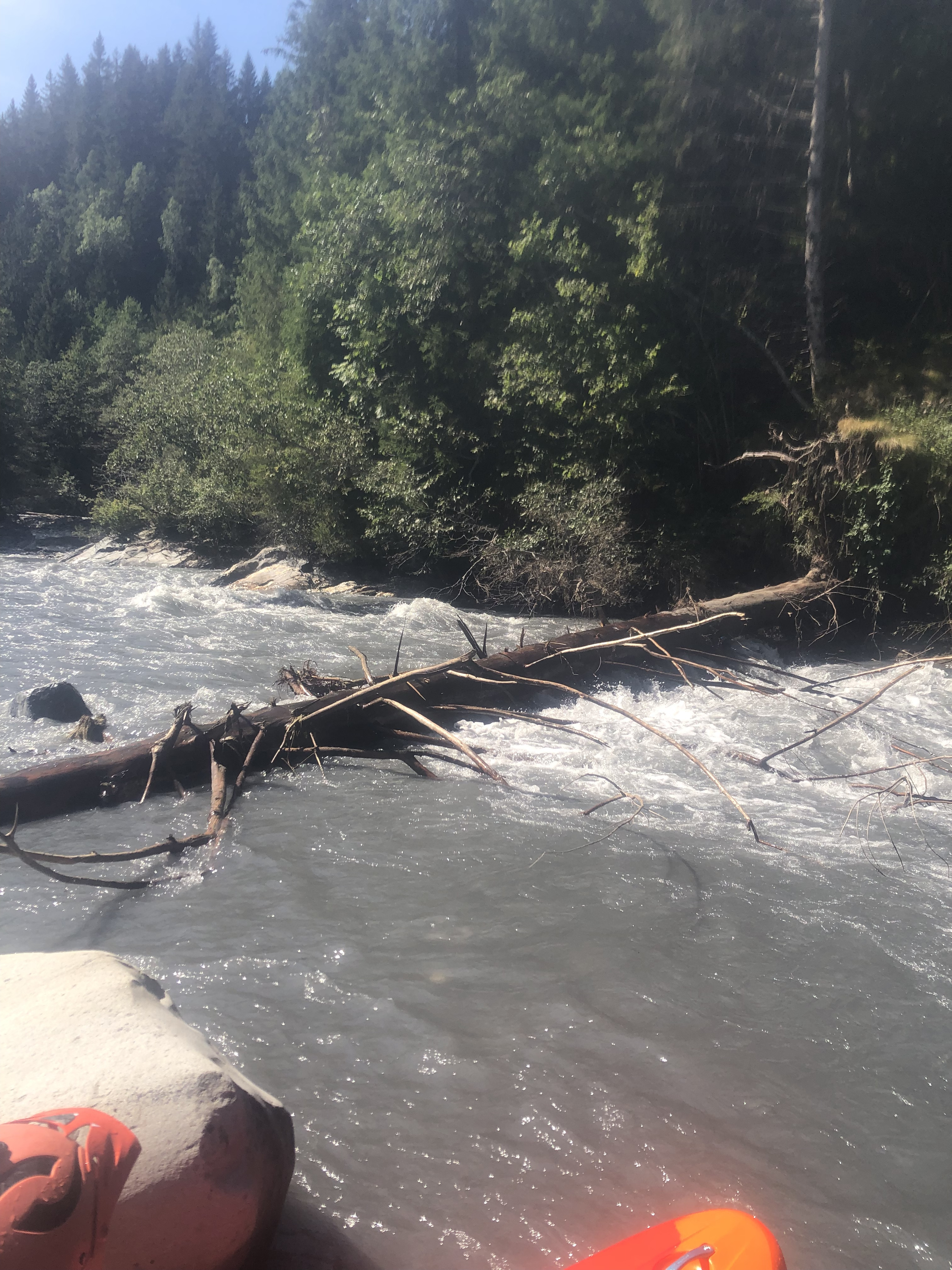 • #5493 • 03.09.2023 11:07
Inn (CH), Giarsun
• #5492 • 02.09.2023 20:19Venter Ache (AT), Untere (P4 - Zwieselstein)
Befahrbarkeit
Gepaddelt am 2.9.23 (nach dem Hochwasser) bei 70cm. Alles gut fahrbar, wenig Holz nicht in Fahrlinie
• #5490 • 02.09.2023 14:24Ötztaler Ache (AT), Obere (Sölden - Bruggen)
Befahrbarkeit
Gepaddelt 2.9.23 Vormittags, Pegel Vent 66 cm.
Alles frei, keine Hindernisse nach Hochwasser
Alles frei, keine Hindernisse nach Hochwasser
• #5489 • 02.09.2023 11:19Koppentraun (AT), Bad Aussee - Koppenrast
There are two trees on the left line far after second cataract.
• #5487 • 31.08.2023 19:52Vorderrhein (CH), Ilanz - Versam
Baggerarbeiten beim schwarzen Loch für ca. 1 Monat
Mitteilung der RhB Abteilung Naturgefahren: ab Montag 4.9. wird für ca. 1 Monat Geschiebe vom Carrerabach rausgebaggert und am Ende des "schwarzen Lochs" dem Vorderrhein beigegeben.
Dadurch können sich die Verhältnisse beim schwarzen Loch und insbesondere die Verengung am Ende zwischen Prallwand und Kiesbank relativ kurzfristig stark ändern.
Es ist auch auf die Lastwagen zu achten, die dabei sind, Geschiebe in den Vorderrhein reinzuschütten.
Meldung weitergeleitet von http://www.swisscanoe.ch/meldestelle
• #5485 • 31.08.2023 16:05Hinterrhein (CH), Albulamündung - Reichenau
Oberhalb dieses Abschnitts befindet sich zwischen Autobahnbrücke und Albulamündung ein doppelwehr mit je nach Pegel gefährlichem Rücklauf!
 • #5484 • 31.08.2023 15:24
Inn (CH), Scuol - Martina
Gefahr aufgehoben
Spühlung vorbei
• #5483 • 31.08.2023 15:15Hinterrhein (CH), Untere Viamala
Falls nach dem Abschnitt Untere viamala ab Thusis weitergepaddelt wird befindet sich 50m nach der Autobahnbrücke, ein schlecht sichtbares doppelwehr mit gefährlichem Rücklauf!
 • #5482 • 31.08.2023 15:15
Inn (CH), Scuoler Strecke
Spühlung vorbei
• #5481 • 31.08.2023 15:15Inn (CH), Ardez
Gefahr aufgehoben
Spühlung vorbei
• #5480 • 31.08.2023 15:14Inn (CH), Punt Nova - Susch
Gefahr aufgehoben
Spühlung vorbei
• #5477 • 31.08.2023 15:12Inn (CH), Brail Schlucht
Gefahr aufgehoben
Spühlung vorbei
• #5476 • 31.08.2023 15:12Soča (SI), Cave/Friedhofstrecke (Srpenica 2 - Trnovo 1)
Info
Paddling on the Soča and Koritnica rivers is permitted from March 15 to October 31 from 09:00 to 18:00.
A fee is charged, which can be acquired online or at tourist info in Bovec.
A fee is charged, which can be acquired online or at tourist info in Bovec.
• #5475 • 31.08.2023 09:14Soča (SI), Quarta Gola/Abseilstrecke (Otona - Kobarid)
Info
Paddling on the Soča and Koritnica rivers is permitted from March 15 to October 31 from 09:00 to 18:00.
A fee is charged, which can be acquired online or at tourist info in Bovec.
A fee is charged, which can be acquired online or at tourist info in Bovec.
• #5474 • 31.08.2023 09:14Moesa (CH), Arabella - Sorte
Bewertung WW-Grad
Hoy lo hemos descendido con un caudal de 32m3 según el medidor, a mi parecer el primer rápido largo de 1km es más difícil de clase II-III. No subestimar esta primera parte porque es más difícil de lo que está graduada, si las comparas con cama-roveredo que tiene una graduación igual, siendo cama-roveredo más facil. Con este caudal de 32m3 se acerca más a III+ o IV- que a un II-III. Para quienes van un poco justos con el grado es mejor iniciar en las partes de abajo antes de hacer esta parte.
• #5473 • 31.08.2023 00:36Moesa (CH), Arabella - Sorte
After approximately the first kilometer, when the first big rapid ends, the river divides in two. On the right side there are some trees in the river, it is still possible to run it but be careful. I think the left side is much better, we didn't check exactly how the river is, but the right side is not good.
• #5472 • 31.08.2023 00:19Strona (IT), Middle (Piana di Fornero - Diga di Vallestrona)
Bewertung NW-MW-HW
The gauge is *indirect*.
It's far downstream of the takeout and downstream of the release from Lake D'Orta
It's far downstream of the takeout and downstream of the release from Lake D'Orta
• #5467 • 29.08.2023 14:45Canal de Huningue (FR), Parc des Eaux Vives, Huningue
Seite: 1 2 3 4 5 . . . 62 63 64 65 66 67 68 . . . 267 268 269
nach oben