Rivermap
HomeThe Map
List View
Befahrbarkeit
English Summary
Karte Einbetten
Systemstatus
Kontakt und Team
Datenlieferanten
Contributor Agreement
The RCSD
Public licenses
Rivermap Japan
![]() "Rivermap Supporter" Group
"Rivermap Supporter" Group
Flusshinweise
Als Grundlage dient wenn immer möglich ein Flussführer.
Seite: 1 2 3 4 5 . . . 53 54 55 56 57 58 59 . . . 267 268 269
Resultate 1101 - 1120 von 5370
Rizzanese (FR), Gorge moyenne (Ponte Novu en amont de Zoza - Pont de Piombato)
Bewertung NW-MW-HW
FR: A l'échelle de Zoza, la calibration était auparavant : Bas=65cm,Moyen=90cm,Haut=140cm
En attente de contributions pour confirmer ou changer ces valeurs avec la nouvelle station automatique de Pont de Zoza.
EN: The Zoza visual gauge was calibrated Low=65cm,Med=90cm,High=140cm
Waiting contributions to confirm or adapt these values to the new automatic Zoza station
En attente de contributions pour confirmer ou changer ces valeurs avec la nouvelle station automatique de Pont de Zoza.
EN: The Zoza visual gauge was calibrated Low=65cm,Med=90cm,High=140cm
Waiting contributions to confirm or adapt these values to the new automatic Zoza station
 • #5746 • 21.03.2024 11:01
Solenzara (FR), Parking de la D268 - Solenzara
Bewertung NW-MW-HW
FR: A l'échelle de Canicciu, la calibration était auparavant : Bas=85cm,Moyen=115cm,Haut=145cm
En attente de contributions pour confirmer ou changer ces valeurs avec la nouvelle station automatique de Canicciu.
EN: The Canicciu visual gauge was calibrated Low=85cm,Med=115cm,High=145cm
Waiting contributions to confirm or adapt these values to the new automatic Canicciu station
En attente de contributions pour confirmer ou changer ces valeurs avec la nouvelle station automatique de Canicciu.
EN: The Canicciu visual gauge was calibrated Low=85cm,Med=115cm,High=145cm
Waiting contributions to confirm or adapt these values to the new automatic Canicciu station
• #5745 • 21.03.2024 10:54Reuss (CH), Amsteg Autobahnrastplatz - Erstfeld
Achtung: Renaturierung flusslinks mit gefährlichem Holz und Drahtseilbefestigung
=> rechts fahren!
ca. 3.8 km nach Amsteg, ca. 500m nach Ellbogen Kapelle
https://maps.app.goo.gl/yffvvgamvbRKDZ1L6
Details siehe: https://www.haho.ch/meldestelle/reuss_renaturierung_hinterleitschach.pdf
SKV-Meldestelle für absehbare Gewässerereignisse
meldestelle@swisscanoe.ch
https://www.swisscanoe.ch/meldestelle
 • #5744 • 20.03.2024 21:33
Canal de Huningue (FR), Parc des Eaux Vives, Huningue
Info
• #5743 • 18.03.2024 17:49Birs (CH), Welle Redingbrücke, Basel
Info
The BAFU forecast graphs are now available here ...
https://data.bs.ch/explore/dataset/100272/custom/?disjunctive.methode&sort=q_max
Grateful thanks to Fachstelle OGD, Daten- & Prozessmanagement, Basel-Stadt for publishing the data.
https://data.bs.ch/explore/dataset/100272/custom/?disjunctive.methode&sort=q_max
Grateful thanks to Fachstelle OGD, Daten- & Prozessmanagement, Basel-Stadt for publishing the data.
• #5742 • 18.03.2024 11:41Schönmünz (DE), Hahnbrunnenwiese - Kirschbaumwassen
Achtung in Schönmünzach wurde dieses Jahr eine neue Brücke gebaut, die zumindest bei höheren Wasserständen nicht mehr unterfahren werden kann. Unter der Brücke ist ein Stahlträger, der bei Hochwasser im Wasser hängt bzw. maximal 20 cm Luft zum Bach hat.
Unbedingt vorher anschauen beim hochfahren und einen geeigneten Ausstieg suchen vor der Brücke.
Anbei erste Fotos von einem Anwohner.
Unbedingt vorher anschauen beim hochfahren und einen geeigneten Ausstieg suchen vor der Brücke.
Anbei erste Fotos von einem Anwohner.
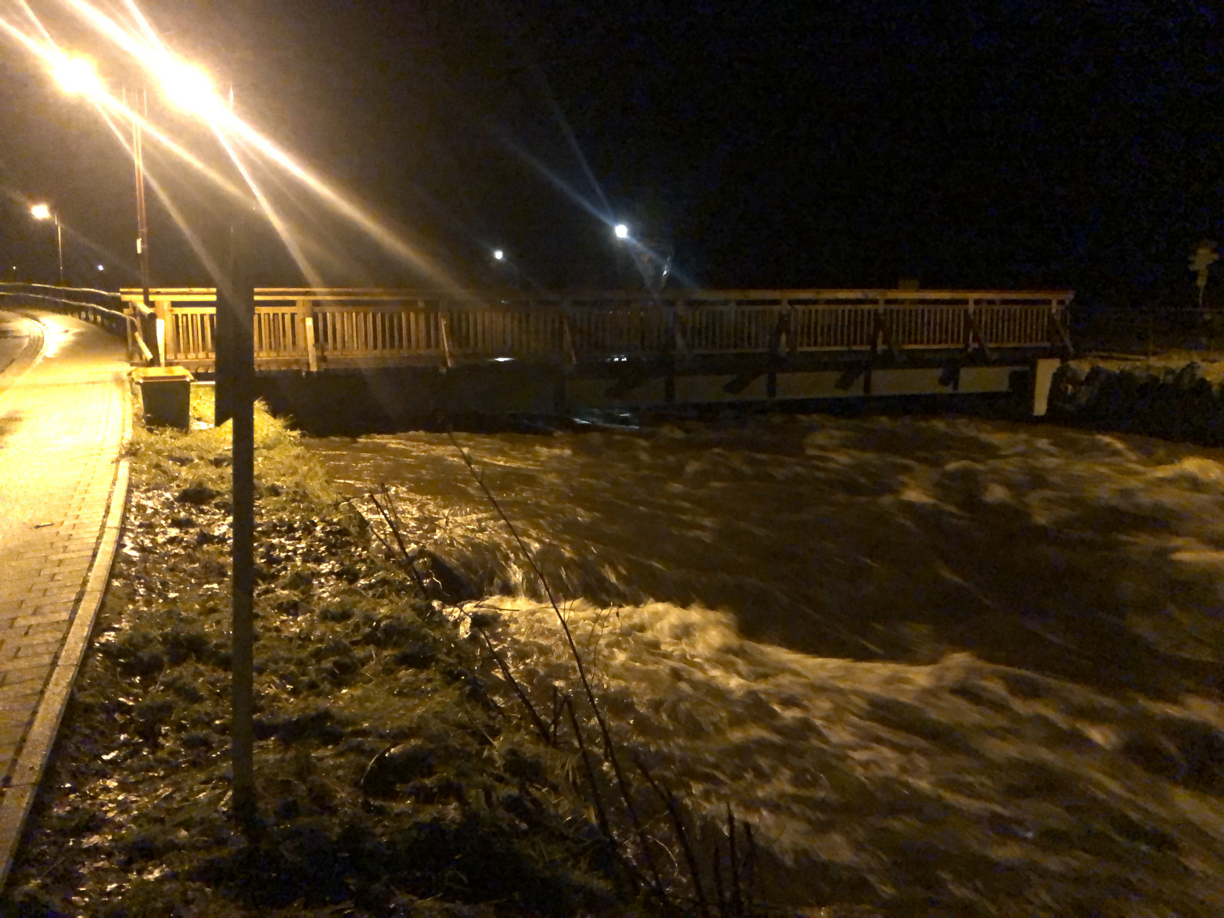
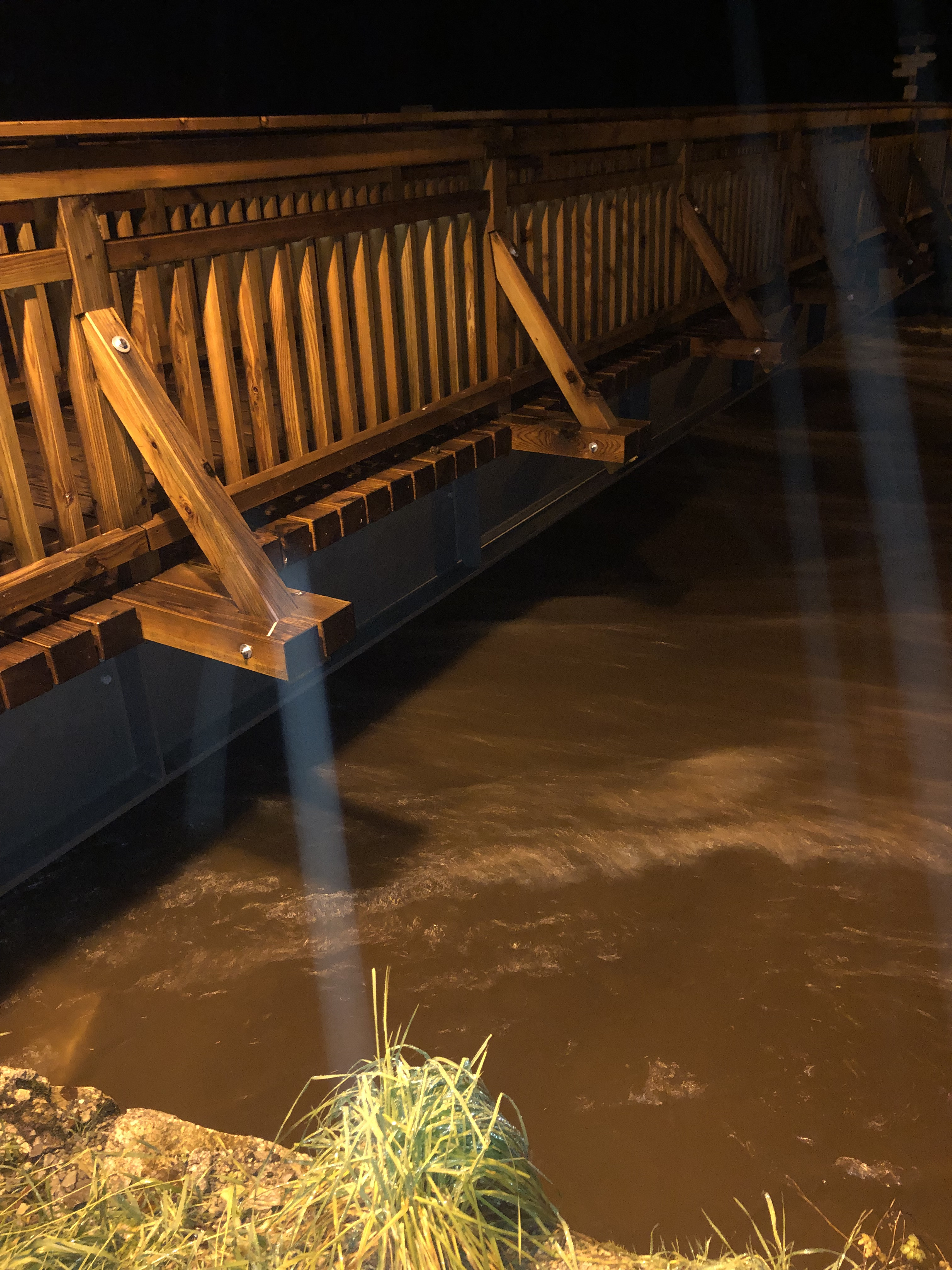 • #5741 • 15.03.2024 23:02
Siagne (FR), Usine électrique au dessus de St.Cézaire - St Cassien les bois
Info
Ran full section at 1.7 m on Feb 13., and at 1.35 m from Rte de Saint-Cézaire bridge to dam at 43°37'59.2"N 6°47'35.3"E on Feb. 16 (at this flow there is not enough water below the dam).
Both the suggested put in and takeout on rivermap are not optimal. Aside from a bit of class 3, there is an ugly sieve and undercut boulder mess rapid just above the Rte de Saint-Cézaire bridge which we portaged at 1.7m. Between Rte de Saint-Cézaire bridge and the dam, Siange is clean and very beautiful class 4 (be prepared for trees). Immediately after the dam a few 100 m with sieves in play and class 4-5, 5ish moves (at 1.7 m) follow. None are must runs but some may require catching small last eddies. Afterwards it eases up. Between the bridge of the Rte de Draguignan and the current takeout there is one class 3 rapid and a weir but otherwise flat.
This section should be split and the put-in and takeout moved (check eauxvives.org). Specifically, I propose placing the put-in at the Rte de Saint-Cézaire bridge and take out at the dam for the upper section (class 4, NW 0.9, HW 1.7, as per eauxvives.org). Note that driving down to the dam is officially forbidden. Second section, from the dam to Rte de Draguignan bridge for easy access (NW 1.4 due to the dam, HW 1.7, class 4-5 (5)). Finally, Rte de Draguignan bridge to Chapelle de Saint-Cassien-Des-Bois (43°36'46.3"N 6°50'37.5"E) (NW 1.4, HW -, class 1-2 (3)). A local told us that this section is forbidden to paddle, but we have not checked that.
In the upper sections, Siagne is a very beautiful river and if you are in the area and find water in it, you should definitively consider running it!
 • #5740 • 12.03.2024 21:07
Soča (SI), Prima Gola/Bunker Run (Lepena - Zmuklica)
Aktivismus
Campaign protesting the new regulations and price increase: 15 "points" daily permit, equivalent to 15 euros in 2024 with a 25cent increase per point each year starting 2025 (30 euros permit in 4 years!).
And 800 euros fine for running the Kataract section, 800 for paddling outside the permitted days/times, 800 for putting-in, taking-out outside the permitted areas.
https://chng.it/sypVsbhDgK
And 800 euros fine for running the Kataract section, 800 for paddling outside the permitted days/times, 800 for putting-in, taking-out outside the permitted areas.
https://chng.it/sypVsbhDgK
• #5739 • 11.03.2024 14:26Soča (SI), Quarta Gola/Abseilstrecke (Otona - Kobarid)
Aktivismus
Campaign protesting the new regulations and price increase: 15 "points" daily permit, equivalent to 15 euros in 2024 with a 25cent increase per point each year starting 2025 (30 euros permit in 4 years!).
And 800 euros fine for running the Kataract section, 800 for paddling outside the permitted days/times, 800 for putting-in, taking-out outside the permitted areas.
https://chng.it/sypVsbhDgK
And 800 euros fine for running the Kataract section, 800 for paddling outside the permitted days/times, 800 for putting-in, taking-out outside the permitted areas.
https://chng.it/sypVsbhDgK
• #5738 • 11.03.2024 14:25Soča (SI), Cataract Section (Trnovo - Otona)
Aktivismus
Campaign protesting the new regulations and price increase: 15 "points" daily permit, equivalent to 15 euros in 2024 with a 25cent increase per point each year starting 2025 (30 euros permit in 4 years!).
And 800 euros fine for running the Kataract section, 800 for paddling outside the permitted days/times, 800 for putting-in, taking-out outside the permitted areas.
https://chng.it/sypVsbhDgK
And 800 euros fine for running the Kataract section, 800 for paddling outside the permitted days/times, 800 for putting-in, taking-out outside the permitted areas.
https://chng.it/sypVsbhDgK
• #5737 • 11.03.2024 14:25Soča (SI), Cave/Friedhofstrecke (Srpenica 2 - Trnovo 1)
Aktivismus
Campaign protesting the new regulations and price increase: 15 "points" daily permit, equivalent to 15 euros in 2024 with a 25cent increase per point each year starting 2025 (30 euros permit in 4 years!).
And 800 euros fine for running the Kataract section, 800 for paddling outside the permitted days/times, 800 for putting-in, taking-out outside the permitted areas.
https://chng.it/sypVsbhDgK
And 800 euros fine for running the Kataract section, 800 for paddling outside the permitted days/times, 800 for putting-in, taking-out outside the permitted areas.
https://chng.it/sypVsbhDgK
• #5736 • 11.03.2024 14:24Soča (SI), Čezsoča - Srpenica
Aktivismus
Campaign protesting the new regulations and price increase: 15 "points" daily permit, equivalent to 15 euros in 2024 with a 25cent increase per point each year starting 2025 (30 euros permit in 4 years!).
And 800 euros fine for running the Kataract section, 800 for paddling outside the permitted days/times, 800 for putting-in, taking-out outside the permitted areas.
https://chng.it/sypVsbhDgK
And 800 euros fine for running the Kataract section, 800 for paddling outside the permitted days/times, 800 for putting-in, taking-out outside the permitted areas.
https://chng.it/sypVsbhDgK
• #5735 • 11.03.2024 14:23Roanne (FR), Pont de la D135 - Coopérative viticole
Befahrbarkeit
super niveau ce 10/03/2024 avec 100 cubes sur la drome .
attention un arbre barre tout le lit de la riviere un km en avale de saint Benoit en Diois
attention un arbre barre tout le lit de la riviere un km en avale de saint Benoit en Diois
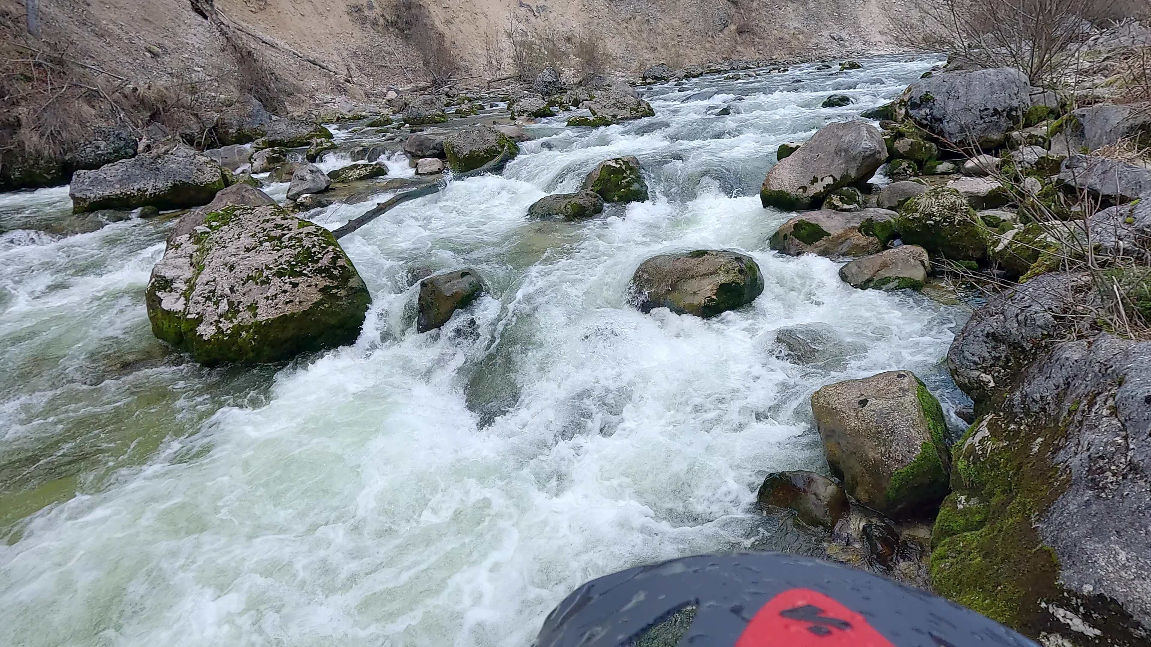
• #5734 • 11.03.2024 09:11Sarca (IT), Medio (Terme di Comano - Villa Banale)
Info
... übrigens der Link zum Video von der "unfahrbaren" Sarcaschlucht. Eventuell steht die heuer mal wieder am Plan.
Unglaublich mühsam aber trotzdem lohnend :)
https://youtu.be/SVFid4_kj9E?si=nkMdkUiANW8bpChG
Unglaublich mühsam aber trotzdem lohnend :)
https://youtu.be/SVFid4_kj9E?si=nkMdkUiANW8bpChG
• #5733 • 09.03.2024 20:24Perticara (IT), S.Anna Pelago - Pievepelago
Gefahr aufgehoben
L'ultima goletta, da qualche anno franata ed ostruita, è ora praticabile. La ricognizione è possibile dalla riva sinistra, che risulta meglio accessibile sbarcando all'inizio della grande pozza che precede la rapida.
• #5732 • 08.03.2024 15:13Vorderrhein (CH), Ilanz - Versam
Der Baum aus Meldung #5718 liegt jetzt ca. 100m weiter Flussabwärts in Längsrichtung zur Strömung.
Kanuschule Versam
Kanuschule Versam
• #5731 • 07.03.2024 11:34Saalach (AT), Lofer-Schlucht
Info
3er Kombi hat sich verändert, nach der Quaderwalze haben sich die beiden Steine in der Mitte bewegt und bilden jetzt einen Schlitz.
Weiterhin fahrbar aber anschauen kann nicht schaden.
Weiterhin fahrbar aber anschauen kann nicht schaden.
• #5730 • 05.03.2024 20:56Koppentraun (AT), Bad Aussee - Koppenrast
Im zweiten Katarakt mittig ein Längsbaum. Rechte Linie schaut bei wenig Wasser (97cm) auch verholzt aus.
 • #5729 • 04.03.2024 12:54
Saane / Sarine (CH), Camping Le Berceau - Lac du Vernex
Bewertung NW-MW-HW
Es gibt seit ein paar Wochen eine neue Pegelmessstation kurz nach dem Einsteg in Saanen, welche nun für diesen Abschnitt angwendet wird. Die Kalibrierung ist noch geschätzt. Bitte Erfahrungswerte an Rivermap melden.
• #5728 • 04.03.2024 12:01Saane / Sarine (CH), Saanen - Camping Le Berceau
Bewertung NW-MW-HW
Es gibt seit ein paar Wochen eine neue Pegelmessstation kurz nach dem Einsteg in Saanen, welche nun für diesen Abschnitt angwendet wird. Die Kalibrierung ist noch geschätzt. Bitte Erfahrungswerte an Rivermap melden.
• #5727 • 04.03.2024 12:00Seite: 1 2 3 4 5 . . . 53 54 55 56 57 58 59 . . . 267 268 269
nach oben