Rivermap
HomeThe Map
List View
Befahrbarkeit
English Summary
Karte Einbetten
Systemstatus
Kontakt und Team
Datenlieferanten
Contributor Agreement
The RCSD
Public licenses
Rivermap Japan
![]() "Rivermap Supporter" Group
"Rivermap Supporter" Group
Flusshinweise
Als Grundlage dient wenn immer möglich ein Flussführer.
Seite: 1 2 3 4 5 . . . 278 279 280
Resultate 21 - 40 von 5596
Adige (IT), Spot Porto S. Pancrazio
Bewertung NW-MW-HW
Known to work between 250 and 270 m3/s. The range could be wider but more observations are needed.

 • #7395 • 15.06.2026 11:02
Weisse Lütschine (CH), Lauterbrunnen - Zweilütschinen
Gefahren-Hinweis/Weiße Lütschine
Moin Moin, die Stelle am ehemaligen Schlachthaus hat am Ende/Ausgang (50 Meter oberhalb Mündung Sousbach) einen relativ riskanten Pinstein. Wasserstand circa 9 Kubik. Beim ersten Run lief alles gut. Beim zweiten habe ich etwas gepennt und mich ordentlich eingeklemmt. Konnte mich zwar wieder rausboxen, aber das war definitiv ne SHITSHOW!
Personen mit dabei: Kathi, Junior und Valle
• #7394 • 15.06.2026 10:34Gimbach (AT),
Im ersten "Schlitz" des oberen Teils, ist in der Linie ein fetter Baum! Lebensgefahr laut Roli, da der die Linie kennt.
 • #7393 • 14.06.2026 23:05
Defereggenbach (Schwarzach) (AT), Oberster
Info
Anfangs Juni 26, wir haben nach der Unfahrbaren noch ein wenig nach unten getragen, da zu wenig Wasser resp. zu steinig...
https://youtu.be/qnUTjczsSzw
https://youtu.be/qnUTjczsSzw
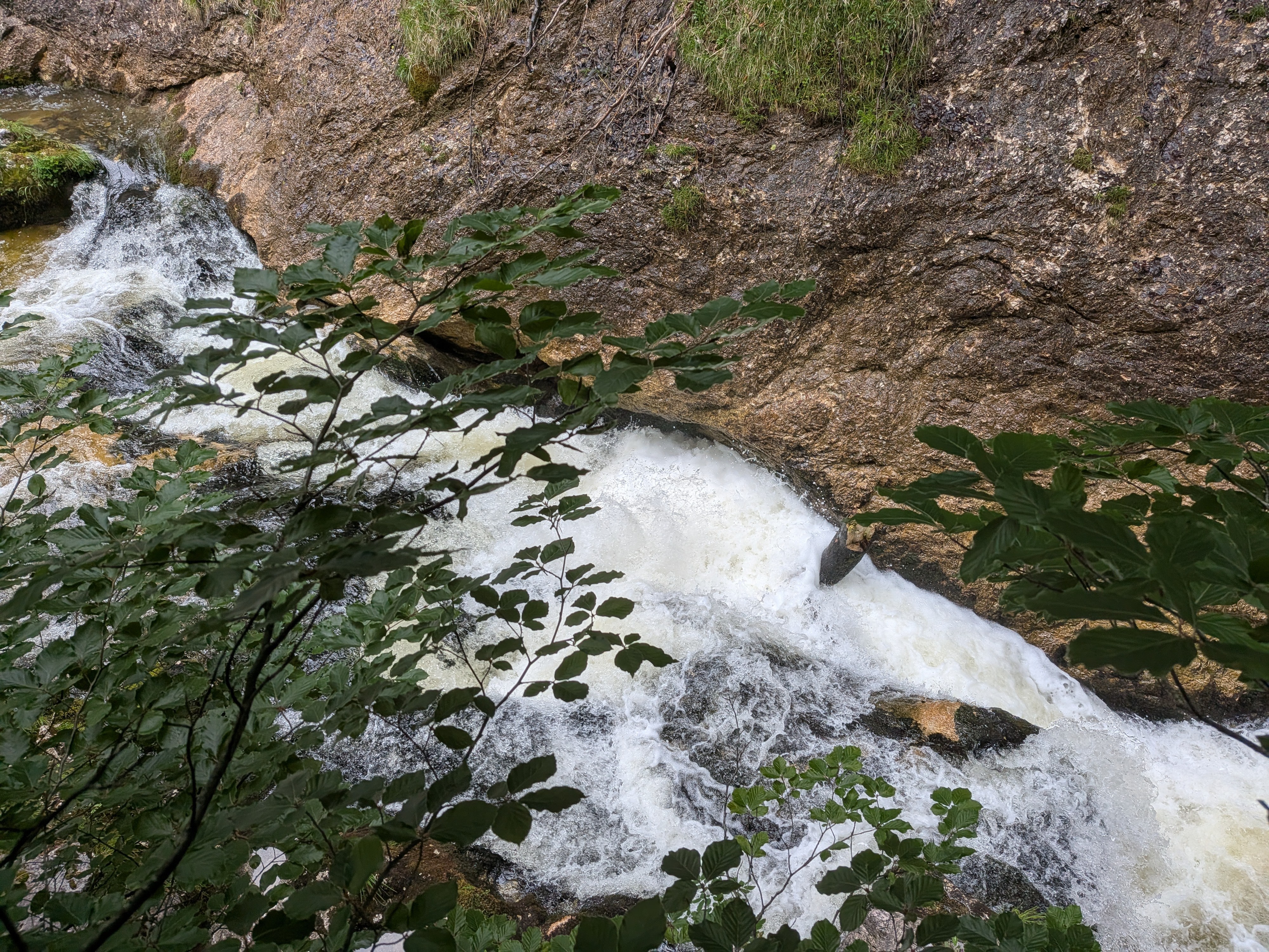
• #7392 • 14.06.2026 22:40Glenner (CH), Uors - Peiden
Fotos zum Baum, Hinweis 7377
 • #7391 • 14.06.2026 19:59
Gail (AT), Mittlere, St. Lorenzen - Birnbaum/Nostra
Tree at 46.695571,12.786547
To paddle over 75 cm would be needed.
To paddle over 75 cm would be needed.
• #7390 • 13.06.2026 21:50Loisach (AT), Griesenschlucht
Divers
Zufahrt zum Ausstieg kann durch Bauarbeiten eingeschränkt sein.
• #7388 • 12.06.2026 21:57Schwarze Lütschine (CH), Lütschental - Zweilütschinen
Bewertung NW-MW-HW
WIr sind am 3. Juni mit ca 75-80cm die schwarze Lütschine gepddelt. Fühlte sich wie Mittelwasser bis unteres MIttelwasser an.. Definitiv noch kein Hochwassercharakter.
• #7386 • 10.06.2026 16:40Giffre (FR), Sixt - Samoëns
Information travaux – Navigation dans le Haut-Giffre (74), commune de Sixt-Fer-à-Cheval – printemps été 2026
Un pont est en cours de reconstruction à l’entrée du village de Sixt-Fer-à-Cheval.
Les travaux ont lieu de mars à fin septembre 2026.
Pour des raisons de sécurité, la navigation sur le Giffre, pour les pratiques encadrées comme individuelles, est réglementée en concertation avec les clubs locaux.
Lors des survols ponctuels du cours d’eau par la grue de l’entreprise Est Ouvrages, des arrêts de navigations de quelques minutes sont imposés aux pratiquants.
Une fermeture totale à la navigation est prévue durant 3 journées, entre le 25 juin et le 25 juillet (dates prévisionnelles).
Un affichage est prévu sur site pour informer les pratiquants, ainsi qu’un arrêté municipal.
Pour tout renseignement, vous pouvez prendre contact avec :
L’entreprise Est Ouvrages qui planifie et réalise les travaux de reconstruction du pont : Corentin Lefèbvre 06 40 48 45 38
Altitude Rafting basé à Sixt-Fer-à-Cheval : David Julou 06 42 52 00 38
La Mairie de Sixt-Fer-à-Cheval : Nicolas Gogué-Meunier 06 46 23 48 96
.
• #7385 • 09.06.2026 15:03Grand'Eyvia (IT), Cretaz - Centralina
Info
Updated after the 2024 flood:
1st part, until the bridge (road on the right hand) :
the initial gorge section remains much the same;
beyond that, the flood has washed out most of the features, levelling out the gradient
2nd part, after the bridge (road on the left hand) :
before the hardest rapid, the flood has washed out a part of the riverbed, making it less interesting
after the hardest rapid, same but way less
• #7384 • 09.06.2026 12:16Grand'Eyvia (IT), Cretaz - Centralina
Info
Update after the 2024 flood:
the initial gorge section remains much the same;
beyond that, the flood has washed out most of the features, levelling out the gradient
the initial gorge section remains much the same;
beyond that, the flood has washed out most of the features, levelling out the gradient
• #7383 • 09.06.2026 12:10Guil (FR), Combes de Château Queyras et de l'Ange gardien (Château Queyras - La Triple Chute)
Info
Mekong packraft four pieces black paddle lost. Please Contact at +34679525437
• #7382 • 09.06.2026 11:10Guil (FR), Combes de Château Queyras et de l'Ange gardien (Château Queyras - La Triple Chute)
Info
Mekong packraft four pieces black paddle lost. Please Contact at +33679525437
• #7381 • 09.06.2026 11:08Albula (CH), Landwasserbrücke - Surava
Info
Die Messtelle befindet sich direkt nach dem Zufluss von einem Kraftwerk in Tiefencastel (direkt nach dem Ausstieg der Waldschluchtstrecke) deshalb kann man sich schlecht an diesem Pegel orientieren.
Am 5.6 runtergerutscht bei Hilfspegel 22 m^3/s, waren schlussendlich geschätzt auf dem Bach 5 m^3/s würde es nicht empfehlen bei diesem Wasserstand, besser Anfahrtszeit sparen und Landquart oder Vorderrhein paddeln.
Am 5.6 runtergerutscht bei Hilfspegel 22 m^3/s, waren schlussendlich geschätzt auf dem Bach 5 m^3/s würde es nicht empfehlen bei diesem Wasserstand, besser Anfahrtszeit sparen und Landquart oder Vorderrhein paddeln.
• #7380 • 07.06.2026 22:23Muota (CH), Muotathal, Fussballplatz - Illgau, Holzlagerplatz
Befahrbarkeit
ran it today at around 15 m3/s. everything was clear and there are no portages.
take care if you plan to continue into the lake, the hydraulic of the last dam drop is quite large and definitely life threatening if one was to swim in it.
we recommend to use the regular take out at the bridge.
take care if you plan to continue into the lake, the hydraulic of the last dam drop is quite large and definitely life threatening if one was to swim in it.
we recommend to use the regular take out at the bridge.
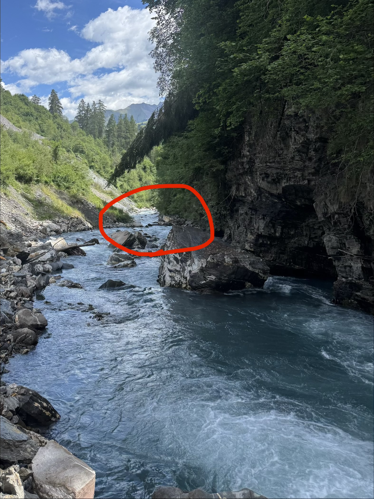
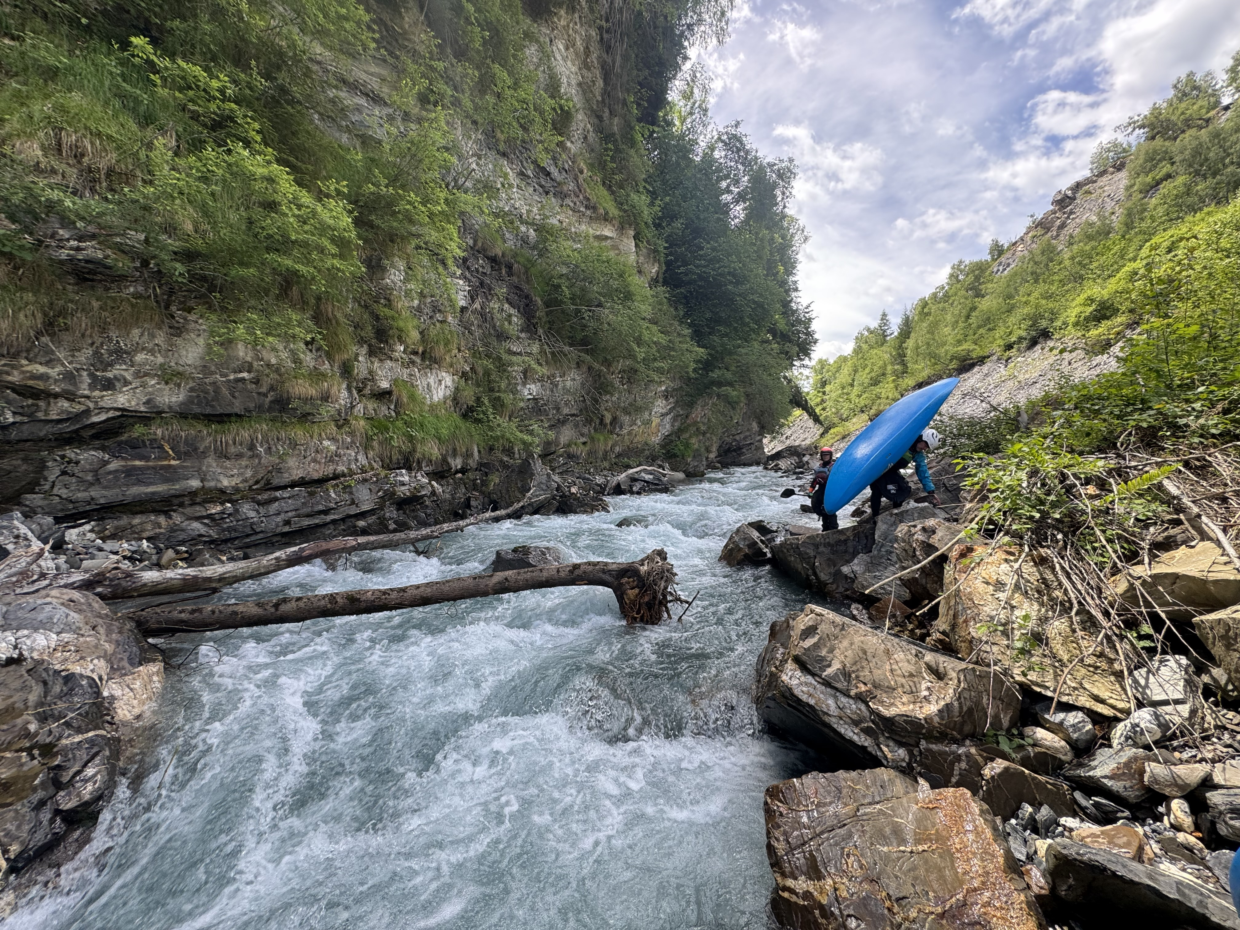
• #7379 • 07.06.2026 13:36Glenner (CH), Peiden - Ilanz
Baum hängt vom Ufer aus direkt nach der Stelle von der Felswand links in die Hauptströmung. Man kommt easy dran vorbei... Wenn man es rechtzeitig sieht... Kann man bereits beim hochfahren anschauen...
 • #7378 • 06.06.2026 08:34
Glenner (CH), Uors - Peiden
Baum Quer.. Sieht man erst spät! Links vorbeifahren je nach Pegel anspruchsvoll bzw riskant. Am besten nach der kleinen Stufe an der Felswand Linksseitig anschauen
 • #7377 • 06.06.2026 08:24
Glenner (CH), Peiden - Ilanz
Befahrbarkeit
we ran it today from about 500 meters or so below the Peiden dam drop.
all clear, no trees.
lines are the same as they used to be.
Cheers,
Kilian
all clear, no trees.
lines are the same as they used to be.
Cheers,
Kilian
• #7376 • 05.06.2026 18:33Landquart (CH), Gulfia - Serneus
Bewertung NW-MW-HW
bei 140 minimal wasser. mitte ca bei 160 geschätzt
einfacher als unten aber auch schnell und steinig
einfacher als unten aber auch schnell und steinig
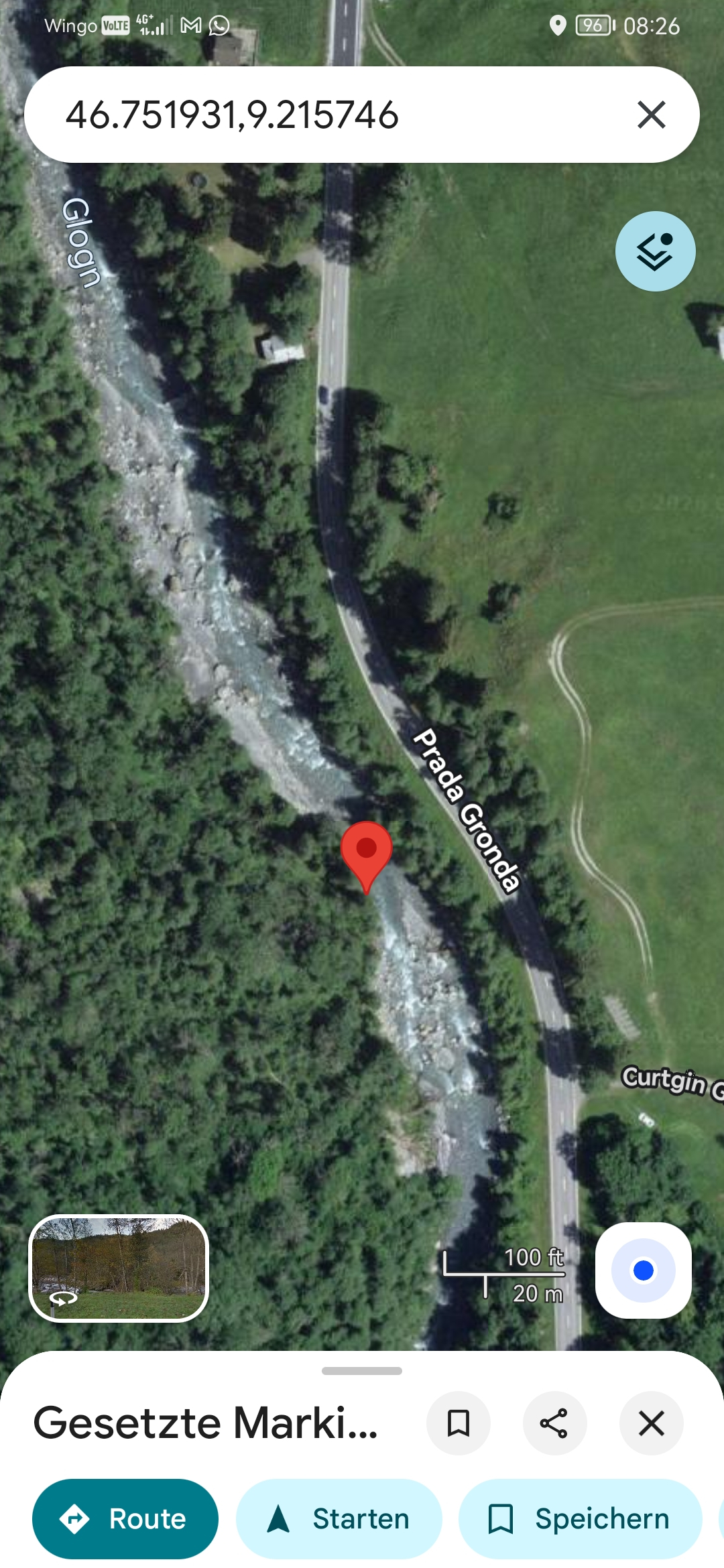
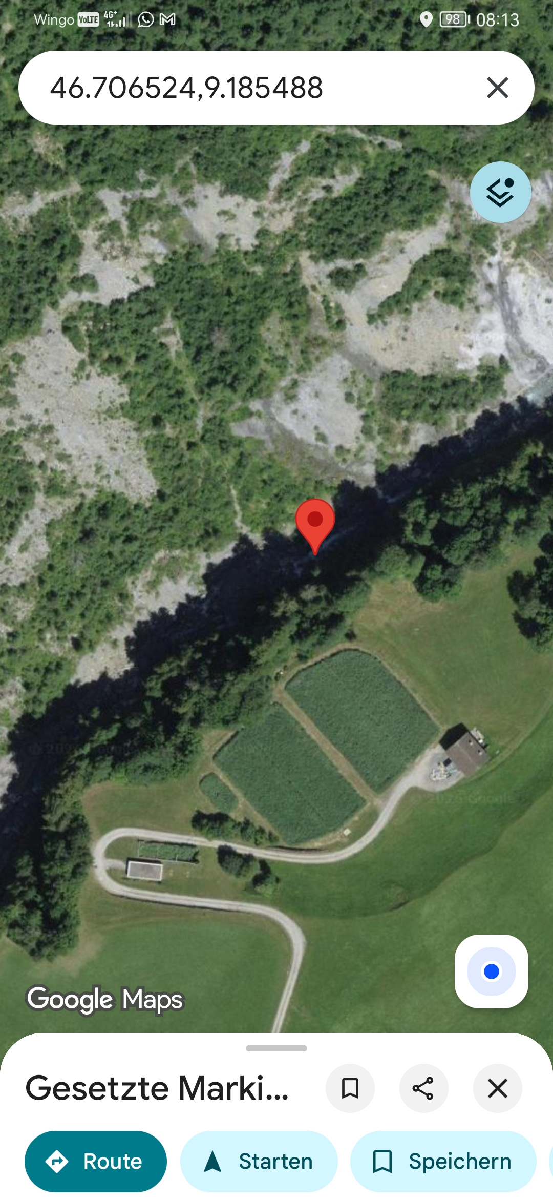
• #7374 • 05.06.2026 14:54Landquart (CH), Serneus - Küblis
https://maps.app.goo.gl/fJ6yuLd199ocJNQZ9?g_st=ac
ungefähr hier. gefährlicher baum. links tragen
ungefähr hier. gefährlicher baum. links tragen
 • #7373 • 05.06.2026 13:54
Seite: 1 2 3 4 5 . . . 278 279 280
nach oben