Home
The Map
List View


 Flusshinweise
Befahrbarkeit
English Summary
Karte Einbetten
Systemstatus
Kontakt und Team
Datenlieferanten
Overview
Download
Rivermap Japan
The Map
List View
Befahrbarkeit
English Summary
Karte Einbetten
Systemstatus
Kontakt und Team
Datenlieferanten
Overview
Download
Rivermap Japan
![]() "Rivermap Supporter" Group
"Rivermap Supporter" Group
Flusshinweise
Als Grundlage dient wenn immer möglich der Flussführer.
Seite: 1 2 3 4 5 6 . . . 223 224 225
Resultate 41 - 60 von 4489
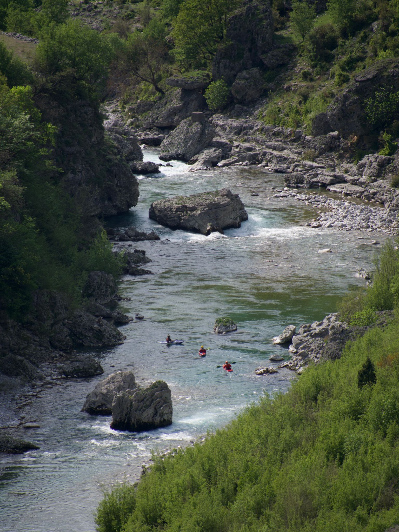
Cem (AL), Lower
Info
I paddled this section on April 10-th 2024 at 80cm. Many good and clean WW 3 rapids. The first four are the most difficult and might even be WW 4. I definitely recommend scouting them. Further down there are some sections with conglomerate rocks with undercuts and siphons. Keep your distance.
We used the put-in and take-out as given here. They worked well and are convenient to access from the road. Don't cross the boarder into Montenegro on the river. There is boarder police watching the river and they have no sense of humor.
We used the put-in and take-out as given here. They worked well and are convenient to access from the road. Don't cross the boarder into Montenegro on the river. There is boarder police watching the river and they have no sense of humor.
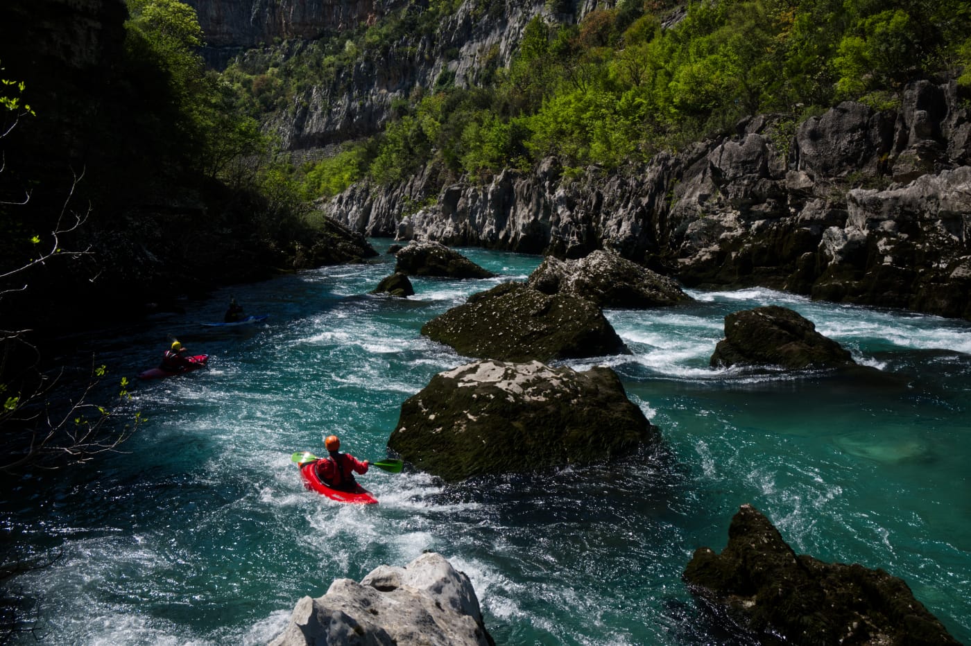
Morača (ME), Middle
Info
I paddled this section on April 9-th 2024 at a level of 80cm. A lot of good and clean WW3, maybe some bordering at 4 at higher levels. We put in a bit higher up at 42.773972, 19.391833, which adds a beautiful extra section passing below the monastery and its waterfall pouring in from an overhanging rock to the right. The put-in required walking through some grassland below the transformer station at the road and finding a path that leads down to the river. We took out river right at 42.703611,19.376722 at the confluence with the Sievernica river, where there is an easy access to the road above. Don't miss this exit because the river goes into the canyon section afterwards without further exits.
The section leads mostly through a dense forest, so watch out for wood in the river. Otherwise the section has far less undercuts and siphons than the lower Moraca.
The section leads mostly through a dense forest, so watch out for wood in the river. Otherwise the section has far less undercuts and siphons than the lower Moraca.

Morača (ME), Lower
Info
I paddled this section on April 7th 2024 at a level of 85cm. We put in a bit lower down, at 42.559333,19.340722, where there is a good access to the river from the road and took out a bit earlier at Autocamp Titograd.
At this level the section is mostly WW 2 with some 3. The rock is mostly conglomerate hence there are many big undercuts and siphons. The passages are wide enough to stay clear of them.
At this level the section is mostly WW 2 with some 3. The rock is mostly conglomerate hence there are many big undercuts and siphons. The passages are wide enough to stay clear of them.
Ribo (CH), Oberer (Steg - Vergeletto)
WATCH OUT!!! A Tree is in the last drop of the little Vergletto Canyon. You can watch it easy river right.
Ribo (CH), Vergeletto-Schlucht
WATCH OUT!!! A Tree is in the last drop of the little Vergletto Canyon. You can watch it easy river right.
Elz (DE), Oberprechtal - Winden
Befahrbarkeit
Eigentlich spannend sind die ca. fünf Kilometer oberhalb der hier in rivermap eingepflegt Einbootstelle. Wer keine Wehre fahren möchte, sollte hier ausbooten. Die Kernstelle ist da, wo die Straße deutlich ansteigt ( nach einem Parkplatz rechts der Straße) bei einem Bildstock, eine Stufe, die ca. 45° abknickt. Die oberste Elz ist etwas für echte Schwarzwaldpaddler, die kleinste Kehrwässer kriegen, auch mal unter Bäumen durchrollen und auch Steinkontakt nicht scheuen. Geht dann, wenn es unten fett Wasser hat und die Rückläufe mächtig werden. Einbootstelle ist bei einem oder zwei allein stehenden Häusern ca.5-6 Kilometer oberhalb.
Moesa (CH), Cama - Roveredo
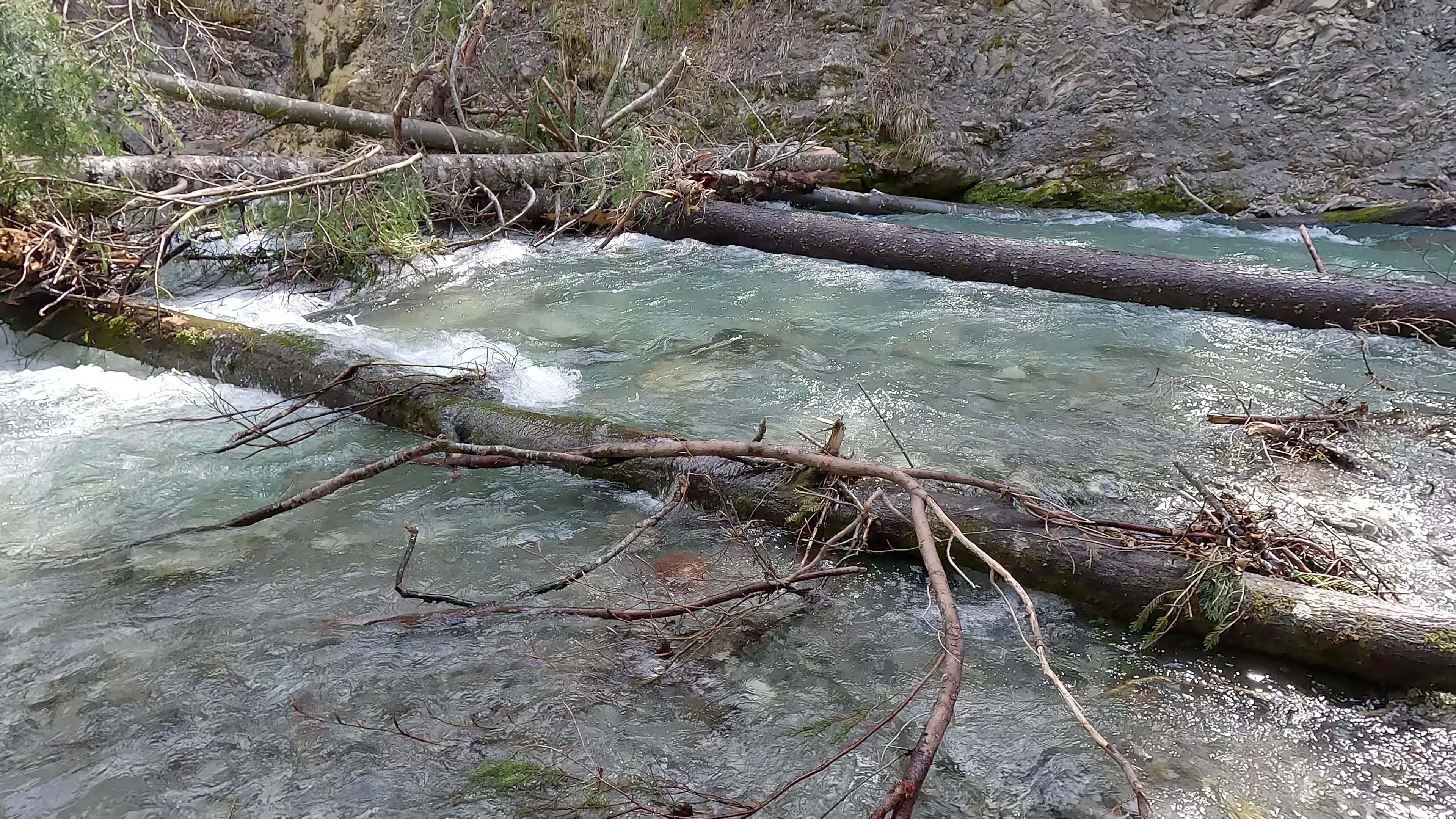
Attenzione! Fra Cama e Leggia sono in corso lavori di manutenzione del patrimonio boschivo in prossimità degli argini. Purtroppo è successo che degli alberi siano stati gettati nel fiume e si stanno incastrando in luoghi potenzialmente pericolosi. Si raccomanda cautela. Sono in corso dei contatti con le autorità per rimediare al problema generato.
Chiarsò (IT), Paularo-Ponte per Lovea
Slizza (IT), Orrido dello Slizza (Tarvisio - Caserma Meloni)
Gulling (AT), Obere Waldschlucht (Hinterauer - Mündung Mittereggenbach)
Breitach (AT), Obere (Schwarzachmündung/Schwendeschlucht - Breitachklamm)
Ca. 150 m nach der "Schieferstelle" (Vgl. Fotos) liegt ein Bauverhau direkt nach einer Linkskurve - eher unübersichtlich. Bei 13m3 muss umtragen werden; bei höherem Pegel könnte ein umfahren rechts möglich sein.


Breitach (AT), Obere (Riezlern, Camping Zwerwald - Schwarzachmündung/Schwendeschlucht
Unter der ersten, hohen Strassenbrücke liegt ein Doppelbaum. Bei viel Wasser ev. überfahrbar. Ganz rechts via Kehrwasser durch den Seitenkanal umfahrbar; oder aber ganz rechts. Vgl. Foto

Limentra (IT),
Bewertung NW-MW-HW
The river can be run when the dam at the Suviana lake is releasing water.
There is a gauge at the lake, measuring the lake level. If it's decreasing then it's maybe possible to run the section.
The gauge is here: https://stations.rivermap.org/station/96fbb0ed-1d1c-439e-af87-f456f9c9074d
There is a gauge at the lake, measuring the lake level. If it's decreasing then it's maybe possible to run the section.
The gauge is here: https://stations.rivermap.org/station/96fbb0ed-1d1c-439e-af87-f456f9c9074d
Albula (CH), Schynschlucht
In der ersten und in der dritten Schlüsselstelle hat es sehr viel Holz. Dritte Schlüsselstelle war die Ausfahrt nicht fahrbar. Baum Queer! Sehr lange und müssahme trage. Bei weiterem war der Fluss an 1 weiteren stellen durch 2 Bäume komplett verstopft. Auch diese können mit Seil rechts umtragen werden!
Bis zum nächsten Hochwasser nicht zu empfehlen.
Bis zum nächsten Hochwasser nicht zu empfehlen.
Ticino (CH), Oberer 2 (Fontana - Airolo)
kurz nach Einstieg aktuell ein grosser Lawinenkegel über die ganze Flussbreite. Es hat extrem viel Schnee im Tal, könnten also noch weitere Lawinenkegel in der Schlucht sein. Wir waren nur zum Skitouren dort.

Ribo (CH), Vergeletto - 300m vor Brücke Strasse Onsemone-Spruga
Baum Quer im Ausgang der ersten Kombi der
Vergeletto Schlucht 100m nach der Brücke.
Sichtbar weder von der Brücke noch in der Anfahrt!
Einstieg direkt unterhalb möglich.
Dangerous Tree 100m below the footbridge in the exit of the first slidecombination in the Vergeletto canyon.
Not visible from the bridge or the boat!
Possible to put on right below.
Ostrach (DE), Aueleklamm (E-Werk - Guferbrücke)
Befahrbarkeit
Alles frei frei frei
Glenner (CH), Peiden - Ilanz
Baum versperrt fast die ganze Flussbreite. Ca 500m unterhalb des Holzplatzes (Ausstieg), bei Kiesbank.. Eine kleine Durchfahrt links ist freigesägt (bei 14m3/s).

Codi (FR), Pont de Passava sous Quenza - Barrage du Rizzanese
Befahrbarkeit
48 cm at the gauge before the Lake. Nice water Level.
Mastallone (IT), Grassura - Bocciolaro
Bewertung NW-MW-HW
Tratto divertente da sotto il ponte della Grassura fino a Bocciolaro ponte della Selva. Livello minimo 120, divertente con livelli 140/150.

Seite: 1 2 3 4 5 6 . . . 223 224 225
nach oben