Rivermap
HomeThe Map
List View
Befahrbarkeit
English Summary
Karte Einbetten
Systemstatus
Kontakt und Team
Datenlieferanten
Contributor Agreement
The RCSD
Public licenses
Rivermap Japan
![]() "Rivermap Supporter" Group
"Rivermap Supporter" Group
Flusshinweise
Als Grundlage dient wenn immer möglich ein Flussführer.
Seite: 1 2 3 4 5 . . . 189 190 191 192 193 194 195 . . . 271 272 273
Resultate 3821 - 3840 von 5445
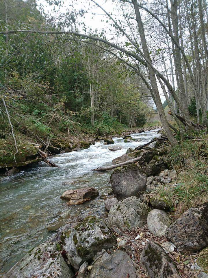
Ticino (CH), Oberer 2 (Fontana - Airolo)
Gefahr aufgehoben
Trees cleared from above grade 4 section on upper ticino. Now possible to paddle full section but still need care as submerged branches
 • #2233 • 09.10.2016 20:15
Lech (AT), Warther Schlucht
Fahrverbot
Habe beim Verkehrsamt die Befahrugsregeln angefragt und eine Befahrung ist nach wie vor nur von 1. März bis 30. September erlaubt: "Auf dem Lech von Flkm 228,309 (Anlegestelle Hinterellenbogen in Steeg) bis Flkm 186,705 (Anlegestelle Riederer Brücke in Weißenbach) darf nur von 1.Mai bis 30.September (9 bis 19 Uhr) eines jeden Jahres gefahren werden."
• #2232 • 27.09.2016 16:39Weisse Lütschine (CH), Lauterbrunnen - Zweilütschinen
Bewertung NW-MW-HW
gefahren am 25.9.2016 bei 3.3m3/s. Geht immer noch gut. Zwischendurch etwas Steinkontakt, es gibt aber immer eine Fahrrinne in der man flüssig fahren kann.

")
 • #2231 • 27.09.2016 11:35
Obere Argen (DE), Eistobel
Am Zwinger hat sich ein neuer Siphon gebildet! Bei wenig Wasser, 4 m³/s, (bin gewandert, nicht gepaddelt) fließt das Wasser vor dem Fels mit der Aussichtsplattform nach links und verschwindet dann unter dem Felsbrocken. Die alte Route (links um den Fels herum) liegt trocken. Außerdem aktuell viel Holz in dem Bereich.
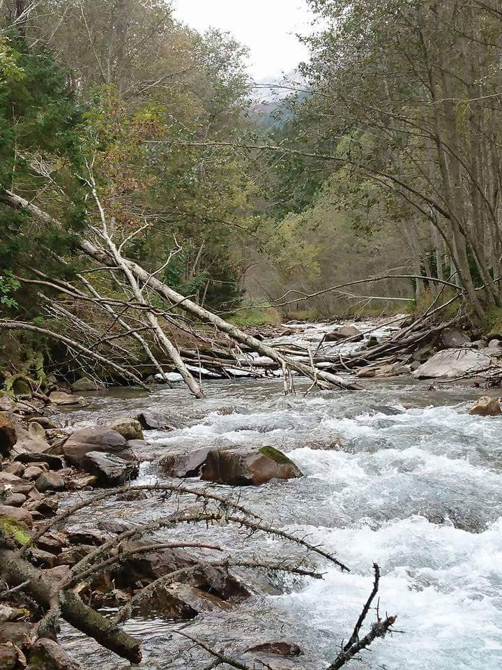
• #2230 • 18.09.2016 22:07Cozon (FR), Entremont le Vieux - St.Pierre
It is not recommended to start at the beginning of this section because it was full of trees in May. This should be checked before the next runs.
• #2229 • 18.09.2016 17:47Vénéon (FR), Les Clots - Base de raft de St.Christophe
Befahrbarkeit
We ran the gorge on the 4/9/16. Very difficult run for us at this water level, quite tiring and technical. It starts with a very short class III section and we carry the unrunnable rapid on the right (you will see a big scree on your right, announcing the portage). The lanscape is wonderful. We carried some rapids, at least 3 or 4, because there were some siphons close to the line. When you are going out of the gorge, there is a section called "the scree". Be careful on this one, as it is changing very often. The end is quite rocky and it is easy to be injured on this rapid. It happened to me on this day, I injured my shoulder on the rocky line just after the 2m drop. I therefore recommend to watch this rapid before running it.
• #2228 • 07.09.2016 16:15Simme (CH), Heideweidli - Erlenbach
Der Faverges-See auf der Plaine Morte (oberhalb Lenk) hat sich ab Samstagmorgen, 27.08.2016, begonnen zu entleeren. Diese erste Phase der Entleerung war ab ca. 04.00 am Sonntagmorgen 28.08.2016 beim Oberwil Pegel ersichtlich (Anstieg von 12 auf 29 Kubik). Diese kommende Woche (29.08.2016 bis ca. 05.09.2016 oder auch länger) muss mit weiteren erhöhten Abflüssen gerechnet werden. Ein Hinweis auf die Entleerung des Gletschersees ist die Trübung des Wassers.
• #2227 • 29.08.2016 09:44Simme (CH), Garstatt - Heideweidli
Info
Der Faverges-See auf der Plaine Morte hat sich ab Samstagmorgen, 27.08.2016, begonnen zu entleeren. Diese erste Phase der Entleerung war ab ca. 04.00 am Sonntagmorgen 28.08.2016 beim Oberwil Pegel ersichtlich (Anstieg von 12 auf 29 Kubik). Diese kommende Woche (29.08.2016 bis ca. 05.09.2016 oder auch länger) muss mit weiteren erhöhten Abflüssen gerechnet werden. Ein Hinweis auf die Entleerung des Gletschersees ist die Trübung des Wassers.
• #2226 • 29.08.2016 09:34Lot (FR), Bagnols les Bains - Nojaret
Info
Some works are currently on going at the place where the flow measurements are done. The water level is artificially modified and 55cm does not mean that this section is runnable!
The works should stop in september.
The works should stop in september.
• #2224 • 24.08.2016 10:32Lonza (CH), Kühmad - Minigolf Wiler
Bewertung WW-Grad
Be careful if you paddle this section with 17m3/s it really becomes a class V to VI and it can be very dangerous for somebody who does not know the river. Especially because there is a rapid in the middle of the section which can become unrunnable because of the trees. It is possible to take out 500m before this rapid which is then too far to be visible (it could be a good option to stop at the bridge after Blatten).
The river difficulty is directly correlated with the flow. It is highly recommended to know the section if you want to paddle it with more than 12m3/s.
The river difficulty is directly correlated with the flow. It is highly recommended to know the section if you want to paddle it with more than 12m3/s.
• #2222 • 22.08.2016 14:54Defereggenbach (Schwarzach) (AT), Tunnelstrecke
Info
I'd propose another take out, at the pedestrian bridge:
46.9225565,12.4758081
We had good run at ~53 (mid-low) but after this point it's really flat, barely class III and quite long.
46.9225565,12.4758081
We had good run at ~53 (mid-low) but after this point it's really flat, barely class III and quite long.
• #2221 • 19.08.2016 13:30Rhein (CH), Chur - Landquart
Sihl (CH), Schindellegi - Hütten
Bewertung NW-MW-HW
Im Moment stimmt der Pegel mit den NW Werten nicht mehr überein (Studie über nun 5 Wochen). Bei 8m3 ist an ein Fahren nicht zu denken. Evt wurde der Pegel neu geeicht. Ein NW ist im Moment erst ab 10m3 möglich. Wer hat die gleichen Erfahrungen gemacht?
• #2218 • 07.08.2016 14:54Inn (CH), Brail Schlucht
Befahrbarkeit
31.7. bei 14m^3. Alles halbwegs sauber fahrbar. Aber bei weniger Wasser kommen ein paar Bäume und Eisen zum vorschein. Definitiv unter MW.
• #2217 • 02.08.2016 17:55Inn (CH), Giarsun
In der 1. echten Stelle nach der Preussenschleuder, also nach dem siphonierten grossen Block, liegt ein Baum quer in der Stufe der rechten Durchfahrt. Unter Umständen erst sehr spät sichtbar. Bei 35m^3 von oben nicht sichtbar und knapp über der Oberfläche, bei 21m^3 immer noch klemmgefährlich aber sichtbar.
Linke Linie fahren oder bei viel Wasser definitiv sauber boofen.
Linke Linie fahren oder bei viel Wasser definitiv sauber boofen.
• #2216 • 02.08.2016 17:50Inn (CH), S-chanf Schlucht
ACHTUNG S-chanfschlucht bei ca. 12 Kubik drei Bäume im Fluss - die ersten beiden (vor dem Campingpllatz) sind rechtzeitig zu erkennen - der zweite an der Prallwand dürfte vor allem bei höheren Pegeln unerfreeuluch sein. Der dritte ca. 500 m nach dem Campingplatz ist erest spät zu sehen und schaut nur knapp aus dem Wasser - rechts vorbei

 • #2214 • 01.08.2016 14:59
Berninabach (CH), Morteratsch - Pontresina
Bewertung NW-MW-HW
Befahrung bei 7 m3/s problemlos. Vorschlag NW: 5 m3/s
• #2213 • 30.07.2016 18:28Albula (CH), Bellaluna - Filisur
Von Alvaneu Bad bis Surava liegen weiterhin kurz vor und kurz nach dem Kieswerk Surava auf Sicht Bäume quer im Bach. Beide können gut umtragen werden.

 • #2212 • 27.07.2016 18:56
Albula (CH), Waldschlucht
Das Holz aus der Waldschlucht wurde grösstenteils entfernt. Nur etwa in der Mitte liegt eine Tanne quer im Bach, wippend auf einem Stein. Kann links umfahren oder umtragen werden.Das Schluchtende ist frei.

 • #2211 • 27.07.2016 18:45
Rhône / Rotten (CH), Untere Rhoneschlucht
Bewertung NW-MW-HW
I think the levels were quite good as they were. the run at 18m^3 a few years back was nice and clean, although a bit pushy, the run this year at 12m^3 was slower but technically just about the same, but with a few nasty siphons just next to the line.
I know that the gauge misses the water coming out of the powerstation just above the put-in, but it's the best we have. Otherwise: just guesstimate the flow at the put in. 7-8m^3 is probably really low, 15m`3 is a nice and easy run with a few pinspots and if the river seems to be in full flow (25m^3 or so), i`d expect a few must runs with big riverwide hydraulics. Anyway, make sure to check the exit-canyon from the road, since at least one of those must run- stoppers will be in there.
I know that the gauge misses the water coming out of the powerstation just above the put-in, but it's the best we have. Otherwise: just guesstimate the flow at the put in. 7-8m^3 is probably really low, 15m`3 is a nice and easy run with a few pinspots and if the river seems to be in full flow (25m^3 or so), i`d expect a few must runs with big riverwide hydraulics. Anyway, make sure to check the exit-canyon from the road, since at least one of those must run- stoppers will be in there.
• #2210 • 25.07.2016 21:33Seite: 1 2 3 4 5 . . . 189 190 191 192 193 194 195 . . . 271 272 273
nach oben