Rivermap
HomeThe Map
List View


 Flusshinweise
Befahrbarkeit
English Summary
Karte Einbetten
Systemstatus
Kontakt und Team
Datenlieferanten
Contributor Agreement
The RCSD
Public licenses
Rivermap Japan
 "Rivermap Supporter" Group
Flusshinweise
Als Grundlage dient wenn immer möglich ein Flussführer.
 RSS-Feed
abonnieren und nichts verpassen.
RSS-Feed
abonnieren und nichts verpassen.
Seite: 1 2 3 4 5 . . . 37 38 39 40 41 42 43 . . . 285 286 287
Resultate 781 - 800 von 5721
Dranse (CH), Sembrancher - Martigny-Croix
Befahrbarkeit
24m3/s.
Rather low but still okay to paddle.
Beginning is easy. It builds up in intensity slowly towards the end.
We had a few trees. 2 of them to portage. Rest could be paddled on the sides with some caution.
Half way we scouted the Undercut passage, but we had no difficulty...
Rest was fun.
The take out is positioned near a football field. Walk up this field to spot a dam. There was a lot of wood in there.
We advise to get out before the dam, and walk...
Not much eddy's available before the dam so stay left towards the end.
Rather low but still okay to paddle.
Beginning is easy. It builds up in intensity slowly towards the end.
We had a few trees. 2 of them to portage. Rest could be paddled on the sides with some caution.
Half way we scouted the Undercut passage, but we had no difficulty...
Rest was fun.
The take out is positioned near a football field. Walk up this field to spot a dam. There was a lot of wood in there.
We advise to get out before the dam, and walk...
Not much eddy's available before the dam so stay left towards the end.

 • #6622 • 01.06.2025 20:14
Germanasca (IT), Campolasalza - Plancia
Info
Run at 15cm, medium level. One tree in the first part that can be avoided on th eleft, otherwise good to go! Team Nirjhara
• #6621 • 01.06.2025 19:06Stura di Ala (IT), Chiampernotto - Ceres
Info
We ran short section from Toma till the ski lift at Ala, about 2.5km of intense grade 4 and a short grade 5 section. Medium-low level at 5cm at Cantoira but level rises quickly in the afternoon. Team Nirjhara
• #6620 • 01.06.2025 18:44Stura di Valgrande (IT), Pialpetta - Chialamberto
Divers
Take-out pin not correct, should be at roadbridge in Chialamberto. The section below has several weirs and lots of iron in the river bed + a questionnalble gorge section at Cantoira that we portaged. The section above Chialamberto was very worthwhile at a level of 5cm, mainly grade 4 with 2-3 harder bits. Team Nirjhara
• #6619 • 01.06.2025 18:39Medelser Rhein (CH), Parde - Baselgia
Bewertung NW-MW-HW
Vorschlag Minimum 60cm neuer Pegel. Das sind gut 4 Steinreihen sichtbar. Mit dem leicht veränderten Bachbett wirds schon ab 65cm (4 Steinreihen frei) recht hakelig...
• #6617 • 01.06.2025 16:11Durance (FR), Le Rabioux - Embrun
Flash!
Found a throwingbag in with the name David.
0033681103368
0033681103368
• #6616 • 01.06.2025 13:58Durance (FR), Le Rabioux - Embrun
Flash!
Found a throwbag from David.
• #6615 • 01.06.2025 13:56Seez (CH), Mels - Walenstadt
Befahrbarkeit
Fahrt mit Packrafts bei 2.7 m3/s. Nur einmal aufgesetzt. Im unteren Abschnitt vermutlich nur möglich, da starke Wasserzufuhr durch Schils nach Flums.
Einstieg oberhalb der Bushaltestelle "Plons (Mels), Dorf". Dauer: 2h.
In Plons (bei 47.056103, 9.402873) war kleine Blockwurfstufe nicht fahrbar (verblockt).
Einstieg oberhalb der Bushaltestelle "Plons (Mels), Dorf". Dauer: 2h.
In Plons (bei 47.056103, 9.402873) war kleine Blockwurfstufe nicht fahrbar (verblockt).
• #6614 • 01.06.2025 10:07Glenner (CH), Oberster (Vrin - Surin)
Flash!
Wurfsack weAdel am linken Ufer am Ende der Ver Stelle liegen gelassen. Falls du ihn findest, bitte Nachricht an y.kobler@gmx.ch
Vielen Dank
Yvonne
Vielen Dank
Yvonne
• #6613 • 01.06.2025 10:05Seez (CH), Mels - Walenstadt
Fahrverbot
Auskunft zum Schiessbetrieb nur zu den Bürozeiten Mo-Fr. Es ist auch samstags Schiessbetrieb möglich
• #6612 • 01.06.2025 09:53Valser Rhein (CH), Oberer (Brücke - Lunschania)
Info
Befahren am 30mai 2025. Baumfrei. 4 tragen. wasserlevel 60cm auf valserpegel. Absolutes nidrigwasser. vieles wird vermutlich schöner und sauberer mi 5-15cm mehr.


 • #6611 • 31.05.2025 13:30
Tesina (IT), Spot Bolzano Vicentino
Info
L'onda si forma 10mt a valle della briglia.
ATTENZIONE: non entrare nella prima briglia a valle del ponte, in quanto pericolosa.
ATTENZIONE: non entrare nella prima briglia a valle del ponte, in quanto pericolosa.
• #6610 • 31.05.2025 10:56Passirio/Passer (IT), San Leonardo/St.Leonhard - San Martino/St.Martin
 Gefahr
Attenzione ai moltissimi artificiali lungo il percorso. Almeno due mortali da trasbordare assolutamente
• #6609 • 31.05.2025 10:52Isarco/Eisack (IT), Colma/Kollmann - Campodazzo/Atzwang
GefahrAttenzione ai tondini sotto ai ponti e a ferri sparsi derivati dai lavori di manutenzione all'autostrada
• #6608 • 31.05.2025 10:47Dardagna (IT), La Cà - Ponte SP324
GefahrDue sbarramenti da 10+mt. Uno visibile a circa 500mt dalla partenza [44.190054,10.844133] da trasbordare a DX, il secondo più alto a circa 2/3 del percorso [44.199176,10.857045] (mortale, non ha fondo, trasbordo a DX).
Molti rami e alberi lungo il percorso.
Molti rami e alberi lungo il percorso.
• #6607 • 31.05.2025 10:46Bevera (IT), Olivetta - Torri
Gefahr vorübergehendTronco a tutto fiume alle seguenti coordinate: 43.863093, 7.542960
• #6606 • 31.05.2025 10:40Defereggenbach (Schwarzach) (AT), Tunnelstrecke
Gefahr vorübergehendBaum im 2 Rapid nach dem Tunnel!!
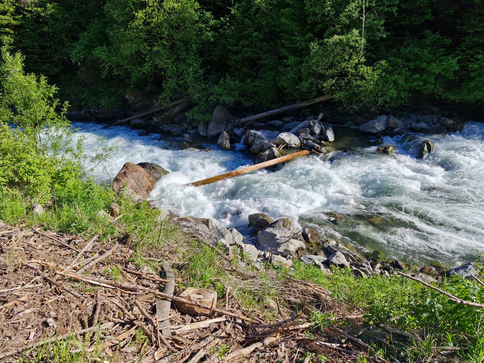 • #6605 • 30.05.2025 22:01
Weisse Lütschine (CH), Lauterbrunnen - Zweilütschinen
Befahrbarkeit
13m3/s.
River is clear. We had Great fun.
Just a few scouts, rest is read and run.
When we drove next to the road to the put in, it all looked very easy.
But there are a few Intenser sections which are further away from the road and cannot be checked while driving.
Have fun!
River is clear. We had Great fun.
Just a few scouts, rest is read and run.
When we drove next to the road to the put in, it all looked very easy.
But there are a few Intenser sections which are further away from the road and cannot be checked while driving.
Have fun!
• #6604 • 30.05.2025 19:36Simme (CH), Heideweidli - Erlenbach
Gefahr vorübergehendCa 500 Meter nach dem Seehund hats rechts einen gut sichtbaren Baumstamm. Links umfahrbar bei 12 M3. Von der Strasse aus sichtbar.
• #6602 • 30.05.2025 16:20Waldemme (CH), Lammschlucht
Gefahr vorübergehendFull of trees. A lot of them can be seen from the hiking trail next to the gorge.
We did not paddle the river.
Unfortunately...
We did not paddle the river.
Unfortunately...
• #6601 • 30.05.2025 13:16Seite: 1 2 3 4 5 . . . 37 38 39 40 41 42 43 . . . 285 286 287
nach oben