Rivermap
HomeThe Map
List View
Befahrbarkeit
English Summary
Karte Einbetten
Systemstatus
Kontakt und Team
Datenlieferanten
Contributor Agreement
The RCSD
Public licenses
Rivermap Japan
![]() "Rivermap Supporter" Group
"Rivermap Supporter" Group
Flusshinweise
Als Grundlage dient wenn immer möglich ein Flussführer.
Seite: 1 2 3 4 5 . . . 134 135 136 137 138 139 140 . . . 271 272 273
Resultate 2721 - 2740 von 5450
Thur (CH), Obere (Mühlau - Schwarzenbach)
Alb (DE), Ibachmündung - Tiefenstein
Info
https://vimeo.com/381709596
Wehr ganz am Schluss getragen; zwei Bäume mussten umtragen werden; ansonsten alles fahrbar. Wir sind den oberen Abschnitt auch mitgefahren.
Wehr ganz am Schluss getragen; zwei Bäume mussten umtragen werden; ansonsten alles fahrbar. Wir sind den oberen Abschnitt auch mitgefahren.
 • #3709 • 30.04.2020 17:52
Alb (DE), Niedermühle - Ibachmündung
Info
https://vimeo.com/381709596
Bei ein bisschen mehr Wasser ist die Umtragung fahrbar. Künstliches Wehr am Schluss (vor Tiefenstein) getragen; bei mehr Wasser wohl fahrbar.
Bei ein bisschen mehr Wasser ist die Umtragung fahrbar. Künstliches Wehr am Schluss (vor Tiefenstein) getragen; bei mehr Wasser wohl fahrbar.
• #3708 • 30.04.2020 17:50Kander (CH), Reutigen - Einigen
Gefahr aufgehoben
Baumhindernis konnte herausgesägt werden. AKT
• #3707 • 30.04.2020 08:26Weisse Lütschine (CH), Lauterbrunnen - Zweilütschinen
Gefahr aufgehoben
Baum entfernt!
• #3706 • 29.04.2020 16:34Inn (CH), S-chanf Schlucht
Pegelwehr, Eisen in nachfolgender Wehrmauer

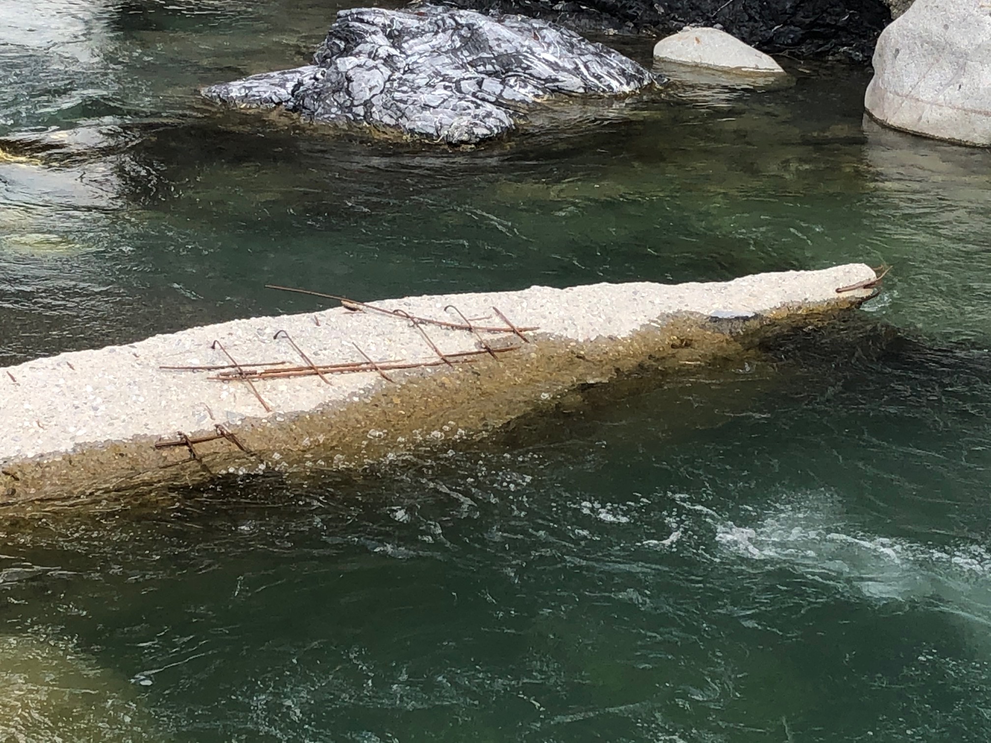 • #3704 • 29.04.2020 11:53
Landquart (CH), Oberlauf
Info
enger, und sehr steiniger gebirgsbach. lohnt sich meiner Meinung nicht wirklich unter ca. 10 kubik, da sehr viel Steinkontakt (befahren bei ca. 7.4).
• #3703 • 26.04.2020 20:27Glenner (CH), Vignon - Uors
Info
Streckenbeschreibung:
Ab Holzbrücke 3.1km ziemlich gleichmässige Schwierigkeiten und Gefälle, dann 300m deutlich steiler, ein Grad schwerer (beginnt mit momentan eher unfahrbarer 2m Stufe), letzte 400m wie am Anfang. Hauptgefahr Holz.
Charakter:
Kies-/Geröllbett, kleinere Stufen. Steine bis Bootsgross, selten bis Auto-gross, etwas Grundgestein. Bei 10m3 WW3+(4) ruhigere Stellen sind vorhanden. Bei steigenden Pegeln wird es immer kontinuierlicher, schneller, weniger Kehrwasser.
• #3700 • 26.04.2020 11:55Glenner (CH), Vignon - Uors
Gefahr aufgehoben
Gestern gesägt, bis auf einen offensichtlichen Baumverhau alles frei.
• #3699 • 26.04.2020 11:38Glenner (CH), Vignon - Uors
Bewertung NW-MW-HW
Zum Sägen am 25.4.2020 gepaddelt bei 8.5m3 erstaunlich "gut" zu paddeln, immer wieder Steinkontakt, aber alles geht gut. Würde auch ohne Säge bei dem Pegel einsteigen, wenn ich nicht auf Adrenalin aus bin. Sehr hübsch. Würde Minimum für befahrbarkeit sogar noch etwas tiefer ansetzen. Wobei, Pegel Ilanz ist typisch aus ca. 50/50 Valser/Glenner, kann aber auch mal asymmetrisch sein, insbesondere Schneeschmelze kommt mehr vom Glenner, dort sind keine Ableitungen.
• #3698 • 26.04.2020 11:37Landquart (CH), Oberlauf
Gefahr aufgehoben
Den Baum aus Beitrag #3671 haben wir heute raus. Der coole Boof ist somit wieder möglich :)
 • #3697 • 25.04.2020 20:54
Engelberger Aa (CH), Wolfenschiessen - Buochs
Baustelle Fadenbrücke
Es wird unterhalb der Fadenbrücke eine neue Brücke gebaut.
Situation ändert sich täglich.
Am besten vorher anschauen oder umtragen. Ausstieg möglich oberhalb der Fadenbrücke linke Fluss Seite.
Es wird unterhalb der Fadenbrücke eine neue Brücke gebaut.
Situation ändert sich täglich.
Am besten vorher anschauen oder umtragen. Ausstieg möglich oberhalb der Fadenbrücke linke Fluss Seite.
• #3696 • 24.04.2020 17:10Ostri (NO), Liavatnet - Dyringen
Info
the blocker mentioned in tore's guide is not there anymore. yet the following left-turn is leading steep along the wall and the right-turn before the end is now even more blocked and powerful.
• #3695 • 24.04.2020 12:02Ostri (NO), Liavatnet - Dyringen
Info
in december 2018, there was a giant flood that destroyed the bridge at take-out. during repair, the 200m of the section (heading straight at the bridge) have been changed drastically. they are easier than before.
yet also other rapids in the section have changed. some need to be scouted before running cause the lines are different now.
yet also other rapids in the section have changed. some need to be scouted before running cause the lines are different now.
• #3694 • 24.04.2020 11:58Ostri (NO), Liavatnet - Dyringen
Info
the bomveg cost 60 NOK and can be payed with VISA card. it is located at Tunet, so you only have to pay once to get to the section, then you can run as often as you want
• #3693 • 24.04.2020 11:54Valldøla (NO), Middle (Langdalen - Grønning)
Info
done in july 2019, level 17m3s and 16m3s, class III+(IV)
wonderful section of whitewater, blocked rapids with a slide or drop every 200m. the two bigger slides are quite challenging. the level was perfect for the first, more difficult half of the section. if level gets below 13m3s, the second half should be little bit too low.
getting out is easy everywhere.
• #3692 • 24.04.2020 11:50Grøvu (NO), Lower (Myra - Gjøra)
Info
done in july 2019, level grenseholen 29m3s, class IV-
for this section the level was perfect. the water is fast but everything was runnable and can be run on-sight. there are enough eddies, too.
for this section the level was perfect. the water is fast but everything was runnable and can be run on-sight. there are enough eddies, too.
• #3691 • 24.04.2020 11:44Grøvu (NO), Lower (Fjellgardan - Myra)
Info
parking at put-in cost 30 NOK.
• #3690 • 24.04.2020 11:42Driva (NO), Romfo (Romfo - Faleøyan)
Info
done on july 2019, level 30m3s, class IV-(V)
after 500m you enter the gorge. at this level the river was still fast and very powerful at the rapids, and at the second rapid most water was pushing right into a wall. be careful here! maybe at higher levels this rapid will be easier, but for the whole gorge there definitely isnt more water needed.
after the gorge and the dam it gets easier. this part could handle a bit more water.
after the takeout to the coast there are more separated rapids (waves and holes) with flat water inbetween.
• #3689 • 24.04.2020 11:02Trysilelva (NO), Femundsundet - Elvbrua
Info
run in summer 2019, level was 45m3s, difficulty III+ (III-IV)
here the river is pretty wide and deep. 90% of this section es easy class II, but the rapids (waves and holes) get bigger and bigger each km. the rapid at the end was large enough to feel a bit disoriented!
here the river is pretty wide and deep. 90% of this section es easy class II, but the rapids (waves and holes) get bigger and bigger each km. the rapid at the end was large enough to feel a bit disoriented!
• #3688 • 24.04.2020 10:49Seite: 1 2 3 4 5 . . . 134 135 136 137 138 139 140 . . . 271 272 273
nach oben