Rivermap
HomeThe Map
List View
Befahrbarkeit
English Summary
Karte Einbetten
Systemstatus
Kontakt und Team
Datenlieferanten
Contributor Agreement
The RCSD
Public licenses
Rivermap Japan
![]() "Rivermap Supporter" Group
"Rivermap Supporter" Group
Flusshinweise
Als Grundlage dient wenn immer möglich ein Flussführer.
Seite: 1 2 3 4 5 . . . 102 103 104 105 106 107 108 . . . 271 272 273
Resultate 2081 - 2100 von 5445
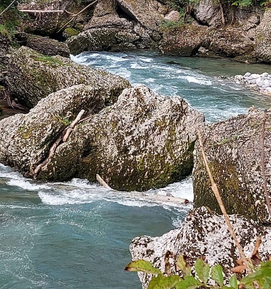
Gurgelener Ache (AT), Obergurgl - Liftparkplatz Pill
Info
Bilder der ersten beiden Stellen in der Schlucht (3. Sept. 2021). Pegel Obergurgl=60cm = unteres MW. Es folgen noch 3 weitere Stellen welche aber weniger kritisch sind.
")
")
")
 • #4598 • 05.10.2021 21:19
Enns (AT), Kummerbrücke
Das Hartelsgraben S hat sich zumindest bei Mindestwasser verändert. Der Prallpolster ist weg und die Hauptströmung zieht in den Schlitz. Der ist gerade frei und man kommt als Schwimmer durch, ist aber wegen möglicher Verklausung nicht zu empfehlen. Der Lieferanteneingang links bietet eine sicherer Alternative.
• #4597 • 03.10.2021 11:10Enns (AT), Kummerbrücke
Gefahr aufgehoben
Eisen ist weg
• #4596 • 03.10.2021 11:07Vorderrhein (CH), Ilanz - Versam
Gefahr aufgehoben
Baggerarbeiten im schwarzen Loch
Die Materialrückgabe, mittels Bagger in den Vorderrhein beim schwarzen Loch, nach den Räumungsarbeiten der Flutwelle aus dem Carrerabach unter der RhB Brücke vom 16.8. sind per 29.9. abgeschlossen worden.
Mitgeteilt von Eichenberger Revital SA
Die Materialrückgabe, mittels Bagger in den Vorderrhein beim schwarzen Loch, nach den Räumungsarbeiten der Flutwelle aus dem Carrerabach unter der RhB Brücke vom 16.8. sind per 29.9. abgeschlossen worden.
Mitgeteilt von Eichenberger Revital SA
• #4595 • 30.09.2021 08:49Dürrach (AT),
Flash!
Habe Kober Platinum Paddel in der Klamm verloren.
Bitte melden unter andreas_webaccount@hotmail.com
Bitte melden unter andreas_webaccount@hotmail.com
• #4594 • 28.09.2021 18:28Kiene (CH), Kiental - Kien
Gefahr aufgehoben
Baumstämme entfernt, Kurve ist wieder fahrbar. AKT
• #4593 • 28.09.2021 13:03Valserine (FR), Niaizet - 300m plus bas
Gefahr aufgehoben
En ce moment il n’y a plus d’arbre obligeant à porter sur la partie engorgée (le Niazet - rapide en aval de l’infranchissable).
• #4591 • 26.09.2021 08:01Ötztaler Ache (AT), Untere (Oetz - Haiming)
Gefahr aufgehoben
Das Brunauer Wehr wurde abgerissen. diese stelle weisst nun ein gleichmäßiges Gefälle über 200m auf. Siehe Fotos vom 3.9 2021

 • #4587 • 20.09.2021 05:32
Reuss (CH), Göschenen - Wassen
Befahrbarkeit
Von Autobahnbrücke bis Mattli gepaddelt am 06-Aug bei niedrigem Wasserstand.Wir hatten unseren Spass. Empfanden es als gutmütig, aber noch sehr gut fahrbar. Der Pegel schwankte etwas beim Paddeln.
 • #4585 • 18.09.2021 08:49
Vorderrhein (CH), Ilanz - Versam
Gefahr aufgehoben
Baum wurde entfernt
• #4583 • 13.09.2021 18:16Dranse (FR), Centrale électrique de Bioge - 800m sous le pont de la D902
There is a three across the river just after the narrow passage "Passe à Morel" at this position (46.337780, 6.572107). Visible from the road.
Stay safe ;)
Stay safe ;)
 • #4582 • 13.09.2021 13:53
Rienza/Rienz (IT), Gole Basse / Untere Rienzschlucht
Befahrbarkeit
Extension to 4552: the tree is after the first rapid after the wooden bridge.
• #4581 • 10.09.2021 18:08Venter Ache (AT), Untere (P4 - Zwieselstein)
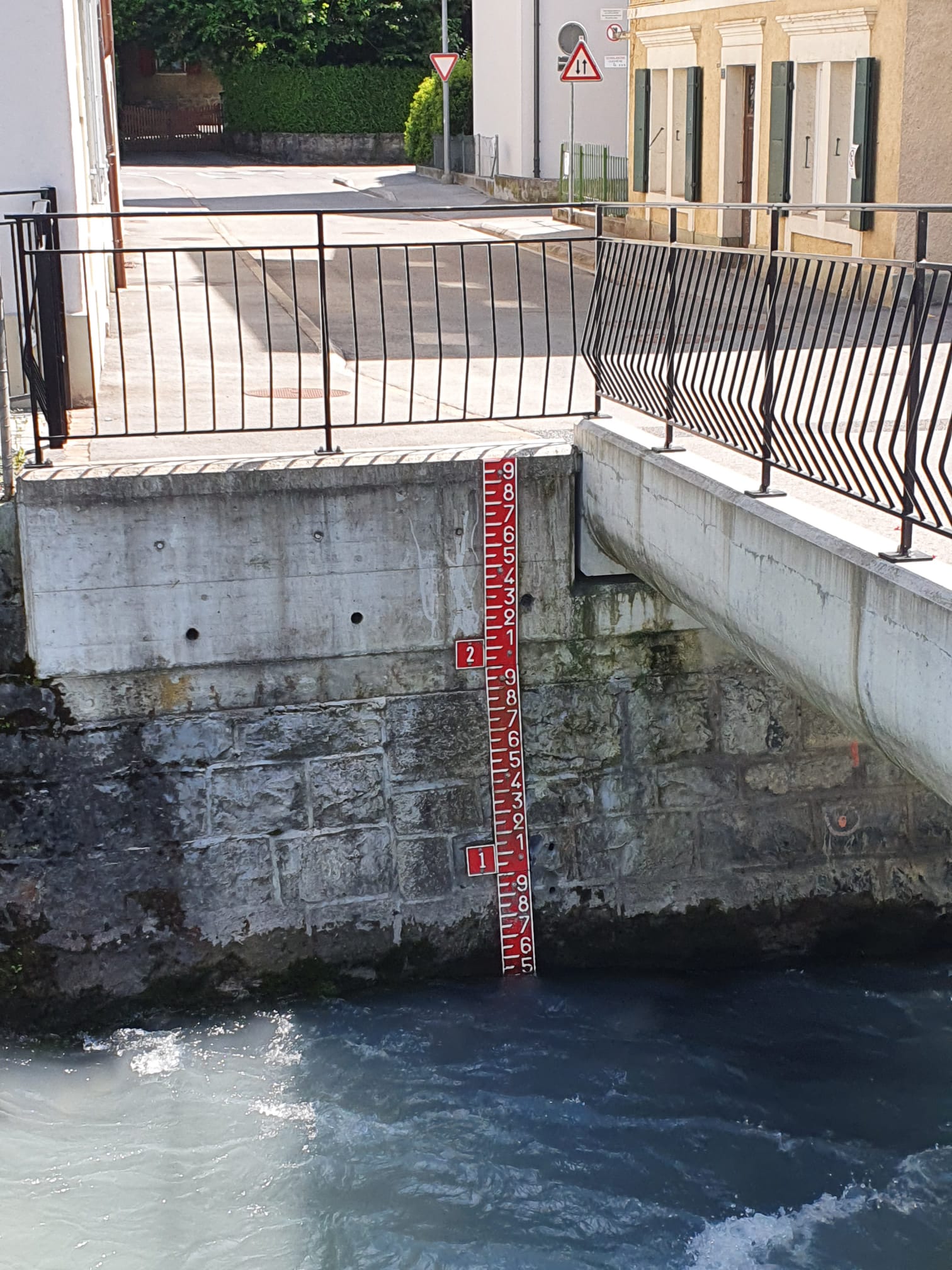
Avançon (CH), Bex - Rhone
Info
Sweet section across the village of Bex. Mainly canalized. Not many eddys. Not specially interesting, but still beautiful in the forest.
 • #4579 • 07.09.2021 11:38
Avançon (CH), Bex - Rhone
Bewertung NW-MW-HW
A visual gauge in the center of Bex (46.249889,7.017452) is a good information about the level. If the gauge is around 0.5 it's a perfect level for a first time run.
Please, let us know the level you run it and the date. It can be useful for the further calibrations of the water levels.
Please, let us know the level you run it and the date. It can be useful for the further calibrations of the water levels.
 • #4578 • 07.09.2021 11:35
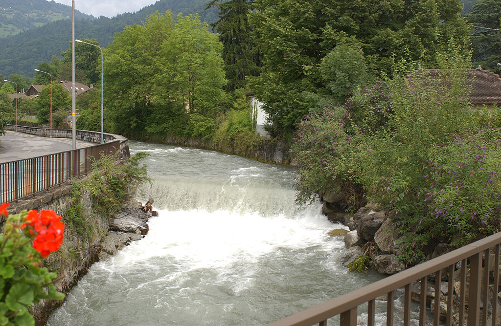
Avançon (CH), Bois du Ban - Bex
Bewertung NW-MW-HW
A visual gauge in the center of Bex (46.249889, 7.017452) is a good information about the level. If the gauge is around 0.5 it's a perfect level for a first time run.
Please, let us know the level you run it and the date. It can be useful for the further calibrations of the water levels.
Please, let us know the level you run it and the date. It can be useful for the further calibrations of the water levels.
 • #4577 • 07.09.2021 11:32
Avançon (CH), Bois du Ban - Bex
Info
Fun section with several artificial drops between 1m and 3m high. All can be boofed in the center. Fast current and not many eddy's. The towback after the weirs can become dangerous by high water level.
(The rapid above the section can be navigated by high water. Rocky class V. Not specially interesting. Put in just below the power plant bridge).
(The rapid above the section can be navigated by high water. Rocky class V. Not specially interesting. Put in just below the power plant bridge).
 • #4576 • 07.09.2021 11:25
Ötztaler Ache (AT), Köfelser Strecke (Brücke - Umhausen)
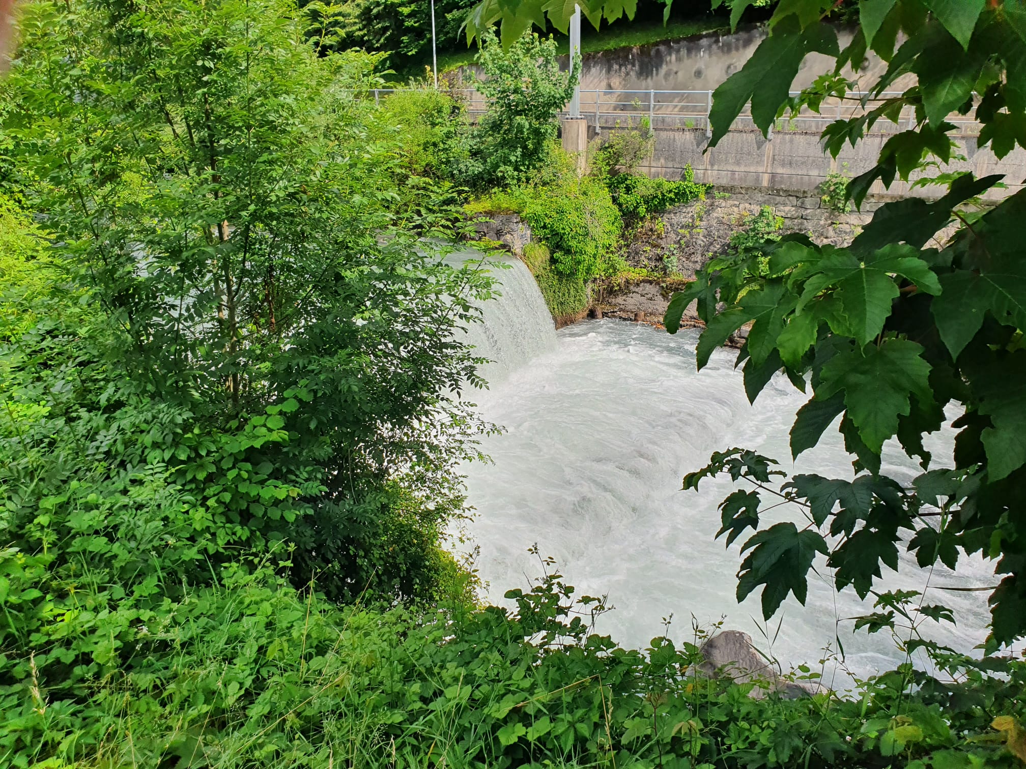
Enns (AT), Kummerbrücke
Befahrbarkeit
At the beginning, under the railway bridge, a roxor/iron bar sticks out of the water. It is in the jump/ step in the middle line (see photo).
Second notice there are logs in place “Nadelöhr“ that water can go over, need to inspect. Photo is at 10,7m3.
Second notice there are logs in place “Nadelöhr“ that water can go over, need to inspect. Photo is at 10,7m3.

 • #4573 • 06.09.2021 18:05
Venter Ache (AT), Untere (P4 - Zwieselstein)
There is a tree at the end of the last rapid before the take out.
No problem at 60+cm, unless swimming. Might have to pay attention at even lower flows
No problem at 60+cm, unless swimming. Might have to pay attention at even lower flows
 • #4572 • 04.09.2021 16:34
Seite: 1 2 3 4 5 . . . 102 103 104 105 106 107 108 . . . 271 272 273
nach oben