Rivermap
HomeThe Map
List View
Befahrbarkeit
English Summary
Karte Einbetten
Systemstatus
Kontakt und Team
Datenlieferanten
Contributor Agreement
The RCSD
Public licenses
Rivermap Japan
![]() "Rivermap Supporter" Group
"Rivermap Supporter" Group
Flusshinweise
Als Grundlage dient wenn immer möglich ein Flussführer.
Seite: 1 2 3 4 5 . . . 159 160 161 162 163 164 165 . . . 271 272 273
Resultate 3221 - 3240 von 5450
Glenner (CH), Uors - Peiden
Im Bereich des Felssturzes (grosser neuer Block im Bach) ist der gesamte linke Hang in Bewegung. Man sieht von der Strasse aus Risse im Gelände, ein Absturz grösserer Mengen an Gestein ist absehbar. Man sollte den Abschnitt meiden und sich nicht unnötig dort aufhalten.
 • #2937 • 02.06.2018 16:41
Medelser Rhein (CH), Parde - Baselgia
Flash!
Werner Powerhouse carbon lost on Cristalina 31.05.2018, If found contact +41764737981
• #2936 • 01.06.2018 09:14Urnäsch (CH), Oberste
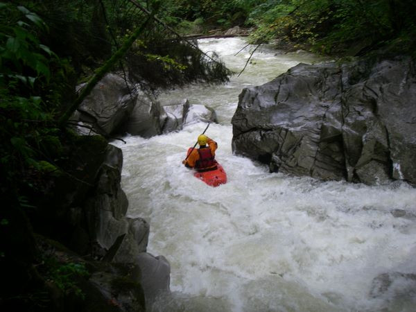
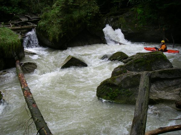
Sitter (CH), Untere Sitterschlucht (Haslen - St. Gallen)
Info
Sitter Wehr St.Gallen 21.12.2008
https://www.youtube.com/watch?v=DjtzYvo9N_0
km 5.1 gemäss SKV Flussführer 1991: ein verfallenes Wehr im Anschluss an eine verblockte Schwallstrecke gewährt nur bei niedrigem Wasserstand einen Durchschlupf durch einen niedrigen, kurzen Tunnel (bei Hochwasser unfahrbar). Rechtzeitig rechts ausbooten und allenfalls umtragen.

 • #2934 • 01.06.2018 08:48
Necker (CH), Oberster (Brücke - Schwanzbrugg)
Info
Eindrücke aus dem Jahre 2008, alle Bilder hier: https://www.twf.ch/bilder-2008-oberer-necker/
 • #2933 • 01.06.2018 08:36
Thur (CH), Welle Bürglen
Muota (CH), Muotathal, Fussballplatz - Illgau, Holzlagerplatz
Info
Kanu Infotafel mit Details zu Einstiegen, Muotastein und Ausstieg
Standort: 46.97766,8.73528
Standort: 46.97766,8.73528
 • #2931 • 01.06.2018 08:12
Muota (CH), Muotathal, Fussballplatz - Illgau, Holzlagerplatz
Fahrverbot
Diese Woche 30.5. - 3.6.18 Kanu WM auf der Strecke http://www.wm-muota2018.ch/home/
• #2930 • 30.05.2018 08:38Breitach (DE), Klammende - Fischen
Baum im Kanonenrohr
 • #2929 • 28.05.2018 18:27
Inn (CH), Scuoler Strecke
Wood in entry to first rapid. Tree stretches from right bank to mid-river rocks. NOT VISIBLE FROM BOAT! Looked to be more of a hazard yesterday, at 50 cubics.
 • #2927 • 27.05.2018 11:28
Reuss (CH), Göschenen - Wassen
Befahrbarkeit
Gefahren am 26.Mai ab Autobahnviadukt.
Freie Fahrt.
Eingebootet um 14:45. Schöner sportlicher Pegel.
Freie Fahrt.
Eingebootet um 14:45. Schöner sportlicher Pegel.

 • #2926 • 27.05.2018 10:03
Roya (FR), Gorges de Saorge (Fontan - Pont de Gémion)
Info
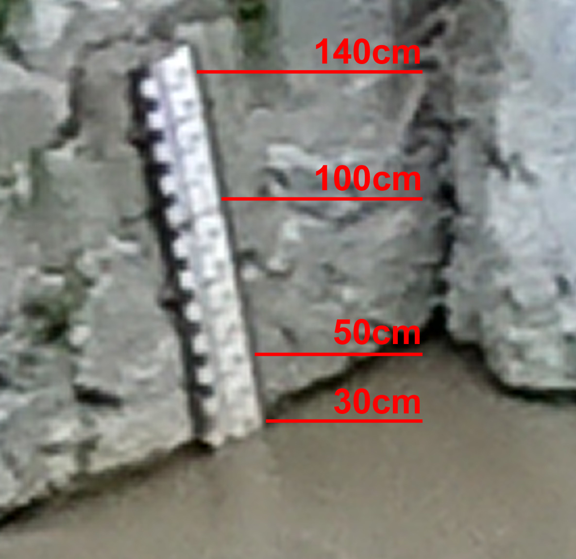
the gauge is very hard to reach as you cannot get close enough.
here is a picture showing it that might help reading it. on that day it was at 30cm. you can barely see the 100cm mark. the top is 140cm.
here is a picture showing it that might help reading it. on that day it was at 30cm. you can barely see the 100cm mark. the top is 140cm.
 • #2925 • 25.05.2018 14:59
Roya (FR), Gorges de Saorge (Fontan - Pont de Gémion)
Info
to get an idea about the difficulties, you could inspect two features.
to reach the first, take the exit between the two tunnels. drive 500m upstream along the river until you reach a bridge. the feature is right there.
for the second feature, walk up from the exit along the river. the road is heavily weathered and barred. after 800m you reach the gauge. another 100m up and you see a cateract with big stones and quite some gradient.
• #2924 • 25.05.2018 14:57Bachelard (FR), Le grand pont D902 - Barcelonnette
Bewertung WW-Grad
the values for NW-MW-HW should be quite fine. but at MW this section clearly isnt III-IV. it is quite fast and the interesting first half is in a canyon and very hard to get out in cast of emergency.
my recommendation is IV.
my recommendation is IV.
• #2923 • 25.05.2018 14:45Var (FR), St.Martin-d'Entraunes - Guillaumes
Strafrechtliches Blockwurfwehr in Guillaumes nach einer Brücke!!! Schlechte Ausstiegmöglichkeit
• #2921 • 24.05.2018 15:37Schwarzenbach (Frauenweißenbach) (AT),
Upper Frauenweissenbach:
Big tree in "Dangerdave line" .
Unrunable there.
Right line is ok.
Photo: https://www.facebook.com/vboyzat/photos/a.656985814319474.1073741826.167669879917739/2283534804997892/?type=3&theater
Big tree in "Dangerdave line" .
Unrunable there.
Right line is ok.
Photo: https://www.facebook.com/vboyzat/photos/a.656985814319474.1073741826.167669879917739/2283534804997892/?type=3&theater
• #2920 • 24.05.2018 10:19Sesia (IT), Scopello - Scopetta
Achtung! großer siphon ca. 500m unterhalb der brücke in scopello. Wir haben ein Boot verloren, ist komplett unter wasser und nicht mehr sichtbar!
• #2918 • 23.05.2018 15:13Isorno (CH), Bagni di Cravegia - Comologno
Bäume in Verblockung gegen Ende vor 4. Brücke, links umtragbar
 • #2917 • 21.05.2018 23:53
Isorno (CH), Bagni di Cravegia - Comologno
Baum kurz nach langer Slide, Kehrwasser rechts, umtragbar
 • #2916 • 21.05.2018 23:50
Isorno (CH), Bagni di Cravegia - Comologno
Befahrbarkeit
befahren am 20.5.2018, bis 4. Brücke (bei Vocaglia), 2x Baum umtragen


 • #2915 • 21.05.2018 23:47
Seite: 1 2 3 4 5 . . . 159 160 161 162 163 164 165 . . . 271 272 273
nach oben