Rivermap
HomeThe Map
List View
Befahrbarkeit
English Summary
Karte Einbetten
Systemstatus
Kontakt und Team
Datenlieferanten
Contributor Agreement
The RCSD
Public licenses
Rivermap Japan
![]() "Rivermap Supporter" Group
"Rivermap Supporter" Group
Flusshinweise
Als Grundlage dient wenn immer möglich ein Flussführer.
Seite: 1 2 3 4 5 . . . 190 191 192 193 194 195 196 . . . 271 272 273
Resultate 3841 - 3860 von 5445
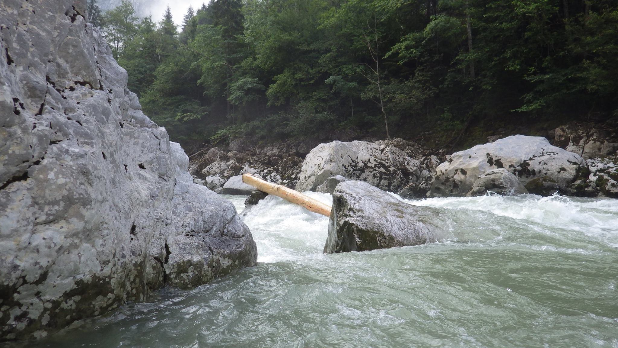
Enns (AT), Kummerbrücke
UPDATE ENNS/KUMMERBRÜCKE von Andi Scherb
DE:
Der Baum in der ersten Stelle der Kummerbrücke direkt unter der Brücke wurde durchgespühlt! Der Baum liegt nun rechts vor der letzten Stelle auf den oberen 600 (Flachwasser).
Ein weiterer Baum liegt in der Mitte in der dritten Stelle, siehe Bilder!
EN:
The tree at the entry of the first rapid of Enns, section "Kummerbrücke", was flushed out and is now lying in front of the last rapid on the right side (flat water).
There is another tree lying in the center of the third rapid, see pictures attached.
 • #2209 • 25.07.2016 11:15
Rhône / Rotten (CH), Susten - Sierre
Bewertung NW-MW-HW
Feel free to comment the new calibration.
Thanks
Thanks
• #2208 • 24.07.2016 09:59Rhône / Rotten (CH), Grengiols - Filet
Bewertung NW-MW-HW
Feel free to comment the new calibration.
Thanks
Thanks
• #2207 • 24.07.2016 09:57Rhône / Rotten (CH), Evionnaz - Saint Maurice
Bewertung NW-MW-HW
Feel free to comment the calibration.
Thanks
Thanks
• #2206 • 24.07.2016 09:55Rhône / Rotten (CH), Untere Rhoneschlucht
Bewertung NW-MW-HW
Any comments on the calibration are welcomed.
Thanks
Thanks
• #2205 • 24.07.2016 09:53Brenno (CH), Aquarossa - Motto
Bewertung NW-MW-HW
Am 19.7.16 bei 3.5 m3/sek gefahren. Fuer NW geht das. Werte fuer NW, MW, HW zu überprüfen.
• #2204 • 22.07.2016 20:29Kalserbach (AT), Knopfbrücke - Parkplatz mit Wasserfall
Befahrbarkeit
We ran it with 64cm on the 17/06/16.
There is a perfect place to sleep if you follow the dirty road on the left side between the put in bridge and the other maybe 1km below.
100% alpin style. There is a warm up during 1km. After the first bridge, the river gets steeper and steeper until you are forced to get out from your boat in order to scout the rapid. Everything is runnable. The rapids are very fast and we had a lot of fun.
• #2203 • 22.07.2016 10:36Tauernbach (AT), Standardstrecke
Befahrbarkeit
Ran with 165cm
Be careful, at the middle there is an unrunnable gorge. When you enter there is a rope on the left in order to show you the way to get out. You can put in after the gorge. You can’t see it from the road.
https://vimeo.com/139264695
Be careful, at the middle there is an unrunnable gorge. When you enter there is a rope on the left in order to show you the way to get out. You can put in after the gorge. You can’t see it from the road.
https://vimeo.com/139264695
• #2201 • 21.07.2016 21:09Isel (AT), Iselkatarakt
Befahrbarkeit
Iselkataract done with 290cm. The biggest rapid is at the beginning. You can scout it and set a safety or carry it easily on the left (if the small creek is not too high). After that everything is visible from the boat. For me there is no maximum on this section like on the section of the prekatarakt
• #2200 • 21.07.2016 21:06Isel (AT), PreKaterakt
Befahrbarkeit
Prekaterakt done at 290 cm. I do not think there is a class IV on this section.
• #2199 • 21.07.2016 21:04Defereggenbach (Schwarzach) (AT), Wasserfallstrecke
Befahrbarkeit
Wasserfallstrecke ran on the 16/07/16 with 75cm.
Two beautifull class V rapids in the middle.
At the end there is a big gorge with a must run. You can hardly scout it from the right side. It is made of an undercut followed by a hole. It is not sticky. The hole before the turn is more dangerous. Just make sure there are no trees after the turn.
The tunnelstrecke is a very strong alpin style river. There are some trees and it is a kind of rocky and tricky. You can scout the biggest rapid from the bridge between both tunnels.
The lower part is also very rocky and tricky, there is a dam at the beginning. On those two parts the risk of getting pinned is quite high.
 • #2198 • 21.07.2016 21:03
Defereggenbach (Schwarzach) (AT), Oberster
Info
The road for the first part is only accessible if you pay a toll. It’s 10€.
• #2197 • 21.07.2016 21:00Aurino/Ahr (IT), Schloss (Speikboden - Campo Tures)
Befahrbarkeit
We ran it on the 15/07/16 with 58 cm.
As mentioned in the guide, I think there is no maximum waterlevel for this part. You should scout at least the rapid just below the first bridge before the put in. The complete section is visible from the road, it is easier to scout before to put in and it allows you to paddle without stopping. This section is very fast, maybe 20minutes if you run it without stopping.
Perfect second run after the Reinbachfalls
• #2196 • 21.07.2016 20:58Riva/Reinbach (IT), Cascate di Riva
Befahrbarkeit
It is a sequence of three drops. The first is 1.5 m high, the second 8m and the third about 3.50m.
To go there, drive up the valley above Winkel. Park your car in the car park just below the bridge where the road changes side. Then walk 200m down and you arrived.
We had a medium high water level. The upper limit is given by the third drop. If the water level is too high the take off and the reception will become too boily.
The water levels within the area were: 58 cm on the Ahr et 75cm on the Defereggenbach, 114 on the Isel. It can give an idea.
The water level can change quickly there because of the dam. We had an approximately 10 cm increase of the waterlevel within 15 minutes and it went down again immediately after that.
• #2195 • 21.07.2016 20:56Dora Baltea (IT), Morgex - Le Champs
Befahrbarkeit
We heard from a local that it is possible to link the part Morgex -le champs- with the Avise gorge. There is just a portage of 200m. After the railway bridge you have to stop on the right side. But if you plan to do this, please check that it is feasible with a rafting company.
• #2194 • 21.07.2016 20:53Dora Baltea (IT), Morgex - Le Champs
Befahrbarkeit
In La Salle there is a dam. You can portage it on both sides.
• #2193 • 21.07.2016 20:52Dora Baltea (IT), Champex - Pré-Saint-Didier
Befahrbarkeit
We ran it on the 14/7/16 with 50cm at the Pré-Saint-Didier gauge. You can paddle everything from your boat.
• #2192 • 21.07.2016 20:51Dora Baltea (IT), Ponte di legno - Champex
Befahrbarkeit
Run on the 14/7/16 with 50cm at Pré-Saint-Didier gauge.
It is the end of the artificial part. But it is still quite steep.
It is the end of the artificial part. But it is still quite steep.
• #2191 • 21.07.2016 20:50Dora Baltea (IT), Courmayeur - Ponte di legno
Befahrbarkeit
We ran it on the 14/7/16 with 50cm at the Pré-Saint-Didier gauge. See comments below.
• #2190 • 21.07.2016 20:48Dora Baltea (IT), Courmayeur - Ponte di legno
Befahrbarkeit
For the put in after Champex, follow the road on the right side and on the big turn go straight, the road changes side and you can put in wherever you want. The advantage is that you can also scout the river.
Just under the bridge of the put in there is a car or something like this under the water.
After the put in at the end of the first rapid there is a big siphonny boulder take care.
After that, there are many artificial steps, be careful, sometimes it is difficult to take out just before. Also there are some iron bars in the river.

 • #2189 • 21.07.2016 20:46
Seite: 1 2 3 4 5 . . . 190 191 192 193 194 195 196 . . . 271 272 273
nach oben