Rivermap
HomeThe Map
List View


 Flusshinweise
Befahrbarkeit
English Summary
Karte Einbetten
Systemstatus
Kontakt und Team
Datenlieferanten
Contributor Agreement
The RCSD
Public licenses
Rivermap Japan
 "Rivermap Supporter" Group
Flusshinweise
Als Grundlage dient wenn immer möglich ein Flussführer.
 RSS-Feed
abonnieren und nichts verpassen.
RSS-Feed
abonnieren und nichts verpassen.
Seite: 1 2 3 4 5 . . . 178 179 180 181 182 183 184 . . . 284 285 286
Resultate 3601 - 3620 von 5720
Loire (FR), Rieutord - La Palisse
Info
 • #2799 • 05.04.2018 12:54
Loire (FR), Rieutord - La Palisse
Info
Befahrung bei 7 Kubik, 1.4.2018
Der Wasserstand war grenzwertig (zu wenig Wasser mit 7 Kubik, Mindestpegel überarbeiten?). An vielen Stellen musste die Route durch die Steine angeschaut werden. Etwa im Mittelteil kann ein steckender Ast in der engen Linie gefährlich werden. Ein Wasserfall mit Steckgefahr wurde umtragen. dann gibt es noch eine extrem gefährliche Stelle, flussabwärts links zieht das Wasser in ein tödliches Syphon. auf der rechten Seite dagegen stürzt ein Wasserfall gegen die Wand (VI). Nur für Pros fahrbar. Umtragung rechts möglich, aber relativ aufwändig.
Gesamtbewertung: Geile schlucht, für die man sich viel zeit nehmen muss. wir würden erst ab 9 kubik wieder fahren.
Der Wasserstand war grenzwertig (zu wenig Wasser mit 7 Kubik, Mindestpegel überarbeiten?). An vielen Stellen musste die Route durch die Steine angeschaut werden. Etwa im Mittelteil kann ein steckender Ast in der engen Linie gefährlich werden. Ein Wasserfall mit Steckgefahr wurde umtragen. dann gibt es noch eine extrem gefährliche Stelle, flussabwärts links zieht das Wasser in ein tödliches Syphon. auf der rechten Seite dagegen stürzt ein Wasserfall gegen die Wand (VI). Nur für Pros fahrbar. Umtragung rechts möglich, aber relativ aufwändig.
Gesamtbewertung: Geile schlucht, für die man sich viel zeit nehmen muss. wir würden erst ab 9 kubik wieder fahren.
• #2798 • 05.04.2018 11:35Sitter (CH), Obere Sitterschlucht (Appenzell - Haslen)
Breitach (DE), Klammende - Fischen
 Gefahr vorübergehend
Baum im Kanonenrohr
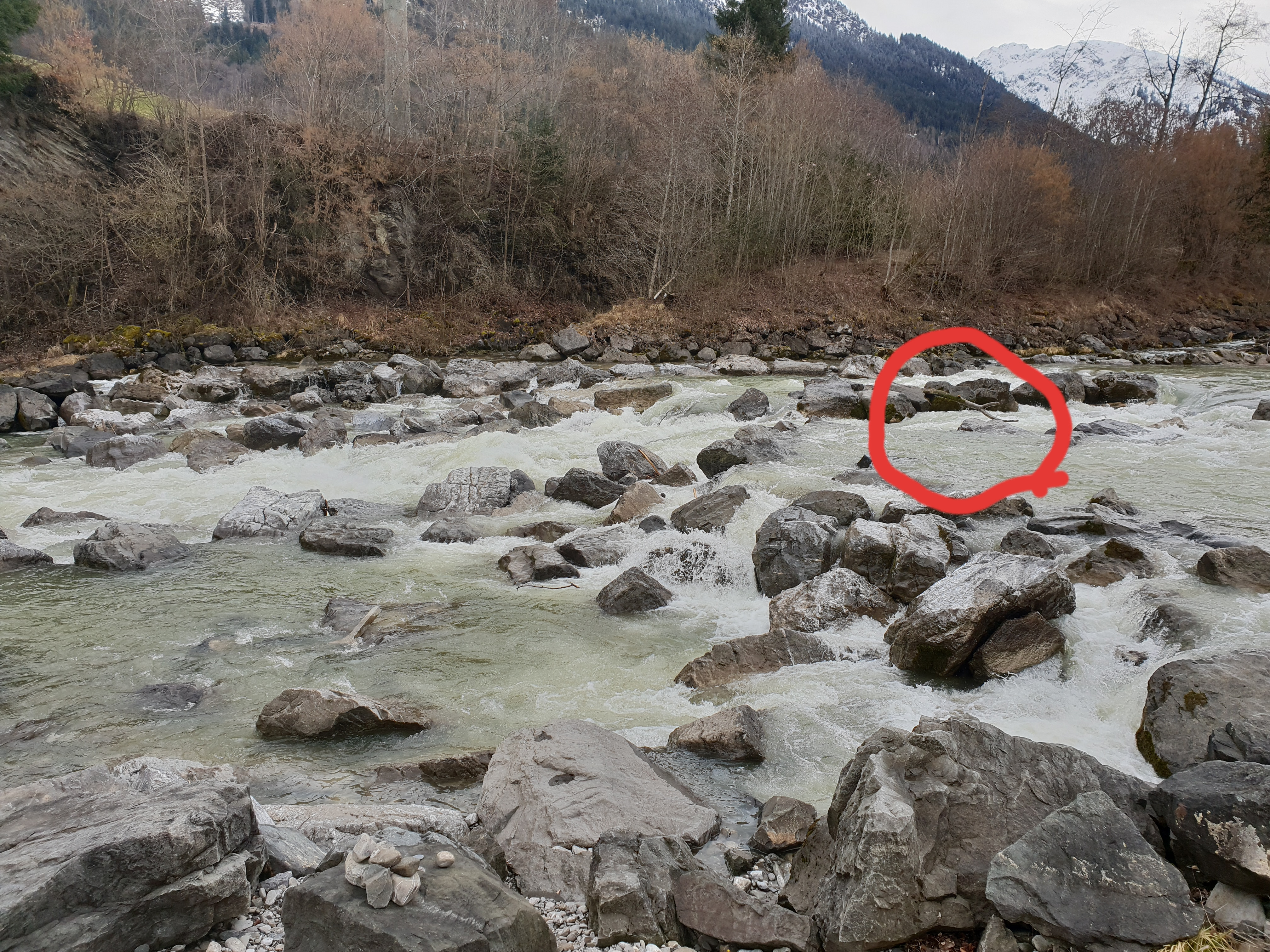 • #2787 • 30.03.2018 10:17
Arzino (IT), Gola 4 (Fraponti - Pert)
Otava (CZ), Čeňkova Pila - Radešov
Bewertung NW-MW-HW
Little change:
LW: 75cm
MW: 100cm
HW: 125cm
LW: 75cm
MW: 100cm
HW: 125cm
• #2785 • 29.03.2018 14:35Fango (FR), Pont de Manso - Ponte Vecchiu
Bewertung NW-MW-HW
26/03/18: I have read on Jan's Corsisa Facebook feed that some paddlers did a run with 67cm. It was said that it was the lowest limit to run this section. The Gravona was 142cm high.
• #2784 • 26.03.2018 20:56Cruzzini (FR), Gorge (Commune de Lopigna - Pont de Truja)
Info
• #2780 • 26.03.2018 17:32Gravona (FR), Camping de Tavaco - Sarrola Carcopino (Pont de Cuttoli, D1)
Info
• #2779 • 26.03.2018 16:50Vecchio (FR), Moyen (Pont de la N193 - Pont de Noceta)
Info
Link to the french evo page for this section :
http://www.eauxvives.org/en/rivieres/voir/vecchio/parcours:1444
http://www.eauxvives.org/en/rivieres/voir/vecchio/parcours:1444
• #2778 • 26.03.2018 16:41Vecchio (FR), Gorge Haute (Canaglia - Pont de la N193)
Info
See evo for a description :
http://www.eauxvives.org/en/rivieres/voir/vecchio/parcours:1443
And be careful with the siphons!
http://www.eauxvives.org/en/rivieres/voir/vecchio/parcours:1443
And be careful with the siphons!
• #2777 • 26.03.2018 16:31Töss (CH), Pfungen - Zusammenfluss Rhein
GefahrOberhalb von Freienstein (bei 47.528616, 8.587303) gibt es eine Wehranlage. Sie ist vor einer Befahrung unbedingt zu besichtigen! Im Normalfall kann bis zum HW Pegel (40m3) auf der linken Seite an der trockenen Wehrmauer ausgebootet, an den Fixseilen abgeseilt und vom unteren Sockel wieder eingestiegen werden. Je nach Schleusenstellung und Wasserstand ist der Sockel überspült, was den Wiedereinstieg erschwert oder unmöglich macht. Bei HW kann oberhalb des Wehres nur erschwert zurückgequert werden. Es gibt eine kleine Anlandestelle auf der rechten Flusseite ca. 40m vor dem Wehr. Diese ist bei HW jedoch nur für versierte Paddler geeignet, da wegen der meist offenen rechten Schleuse eine hohe Strömung fliesst.
Zusätzlich hat es in Freienstein eine Dreierstufe mit einer Fischtreppe auf der linken Seite. Die Fischtreppe wird ab ca. 15-20m3 fahrbar, Besichtigung von der alten Steinbrücke aus möglich. Umtragen auf der rechten Flussseite.
Zusätzlich hat es in Freienstein eine Dreierstufe mit einer Fischtreppe auf der linken Seite. Die Fischtreppe wird ab ca. 15-20m3 fahrbar, Besichtigung von der alten Steinbrücke aus möglich. Umtragen auf der rechten Flussseite.
• #2770 • 24.03.2018 19:57Fango (FR), Pont de Manso - Ponte Vecchiu
Info
Pegel Fango 90 cm
Referenzpegel Gravona 180 cm.
Eventuell kann die Gravona als Referenzpegel für die Bäche dieses Gebietes verwendet werden.
Referenzpegel Gravona 180 cm.
Eventuell kann die Gravona als Referenzpegel für die Bäche dieses Gebietes verwendet werden.
• #2768 • 21.03.2018 21:38Ötztaler Ache (AT), Obere (Sölden - Bruggen)
Sanna (AT), Unterhalb Zusammenfluss - Landeck
Venter Ache (AT), Untere (P4 - Zwieselstein)
Saalach (AT), Lofer-Schlucht
Aurino/Ahr (IT), Schloss (Speikboden - Campo Tures)
Rienza/Rienz (IT), Gole Basse / Untere Rienzschlucht
Boite (IT), Classico (Cortina - San Vito di Cadore)
Seite: 1 2 3 4 5 . . . 178 179 180 181 182 183 184 . . . 284 285 286
nach oben