Rivermap
HomeThe Map
List View


 Flusshinweise
Befahrbarkeit
English Summary
Karte Einbetten
Systemstatus
Kontakt und Team
Datenlieferanten
Contributor Agreement
The RCSD
Public licenses
Rivermap Japan
 "Rivermap Supporter" Group
Flusshinweise
Als Grundlage dient wenn immer möglich ein Flussführer.
 RSS-Feed
abonnieren und nichts verpassen.
RSS-Feed
abonnieren und nichts verpassen.
Seite: 1 2 3 4 5 . . . 83 84 85 86 87 88 89 . . . 285 286 287
Resultate 1701 - 1720 von 5721
Imsa (NO), Lower (Nybru - Imsroa)
Info
done in july 2023, level 12m3s, class III-IV
this river is fast, there are few eddies, but everything can be run on sight. most rapids are class III, but there are also 3 narrow rapids, which are a bit steeper and more powerful. around 1 km before the end, there is an extreme, riverwide stopper. you can see it soon enough and it is easy to portage or sneak it on the right side.
the toll road for entering the valley from the bottom cost 100 NOK.
this river is fast, there are few eddies, but everything can be run on sight. most rapids are class III, but there are also 3 narrow rapids, which are a bit steeper and more powerful. around 1 km before the end, there is an extreme, riverwide stopper. you can see it soon enough and it is easy to portage or sneak it on the right side.
the toll road for entering the valley from the bottom cost 100 NOK.
 • #5440 • 17.08.2023 10:10
Atna (NO), Lower (Trobrua - Mogrenda)
Info
done in july 2023, level 20m3s, class III-IV
this is the second part of the "lower atna". the road along this section is closed for automobiles, so you either shuttle with your bike, or you run it together with "lower atna pt1" - but that would make it a pretty long trip.
the first 2km are almost flat (class II). then, starting at the bridge, there follow 5 long and powerful rapids (class III-IV). they include some bigger holes, but everything can be run without scouting. after that, the second half of the section, the river gets wider and the difficulties go down to class III.
landscape is beautiful and the road is usually a bit farther from the river.
this is the second part of the "lower atna". the road along this section is closed for automobiles, so you either shuttle with your bike, or you run it together with "lower atna pt1" - but that would make it a pretty long trip.
the first 2km are almost flat (class II). then, starting at the bridge, there follow 5 long and powerful rapids (class III-IV). they include some bigger holes, but everything can be run without scouting. after that, the second half of the section, the river gets wider and the difficulties go down to class III.
landscape is beautiful and the road is usually a bit farther from the river.
• #5439 • 17.08.2023 10:10Atna (NO), Lower (Atnabrua - Trobrua)
Info
done in july 2023, level 21m3s, class III(IV)
many flat stretches with beautiful landscape. the rapids between those stretches are usually class III, sometimes a bit less. around 1 km before the end, there is a slide (class IV) which should be scouted for the best spot to run.
this section is the first part of the "lower atna". there is a road parallel to the river, which makes getting out and shuttling easy. the road along the following section "lower atna pt2" is closed for automobiles.
many flat stretches with beautiful landscape. the rapids between those stretches are usually class III, sometimes a bit less. around 1 km before the end, there is a slide (class IV) which should be scouted for the best spot to run.
this section is the first part of the "lower atna". there is a road parallel to the river, which makes getting out and shuttling easy. the road along the following section "lower atna pt2" is closed for automobiles.
• #5438 • 17.08.2023 10:09Enns (AT), Kummerbrücke
Befahrbarkeit
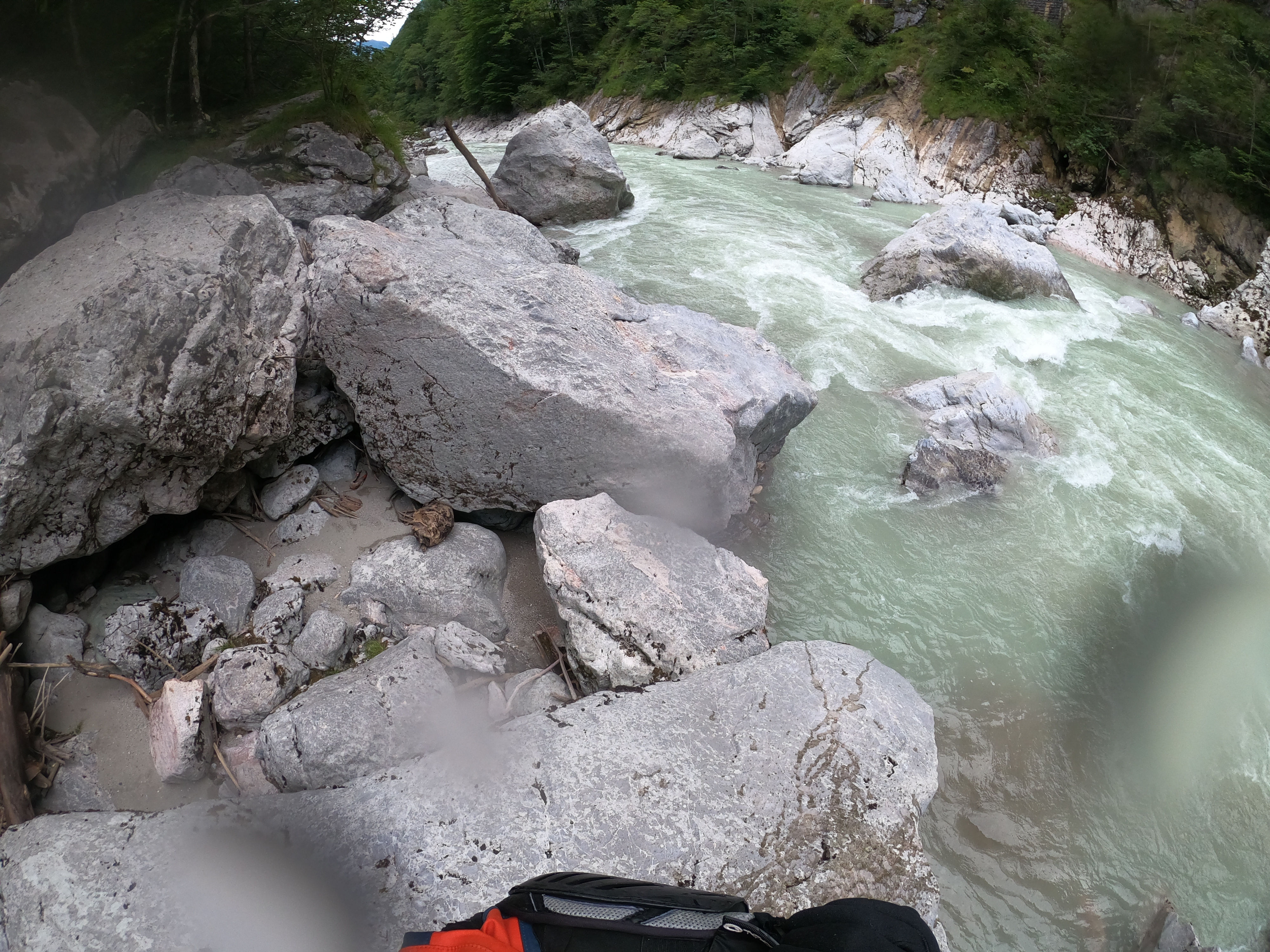
Die untere Kummerbrücke gibt es nach dem Hochwasser und der Stauseespülung nicht mehr. Ennstalhapper, Schlitz und Hartelsgraben S sind nicht wiederzuerkennen oder weg. Es fließt alles mit relativ gleichmäßigen Gefälle dahin. Nur der Katarakt ist noch da. Bei dem großen Felsen am Anfang ist links noch ein Baum. Bis auf den Katarakt ist die Strecke derzeit meiner Einschätzung nach nur noch ein 3er. Das Geschiebe wird sich wieder ausspülen, aber der Schlitz ist definitv weg. Die Felsen liegen unten beim Hartelsbach.
Bei 80m3 in Admont gibt es derzeit überraschende 12m3 für die Kummerbrücke.
Bei 80m3 in Admont gibt es derzeit überraschende 12m3 für die Kummerbrücke.
 • #5437 • 17.08.2023 09:02
Kleine Emme (CH), Entlebuch - Chappelbodenbrücke
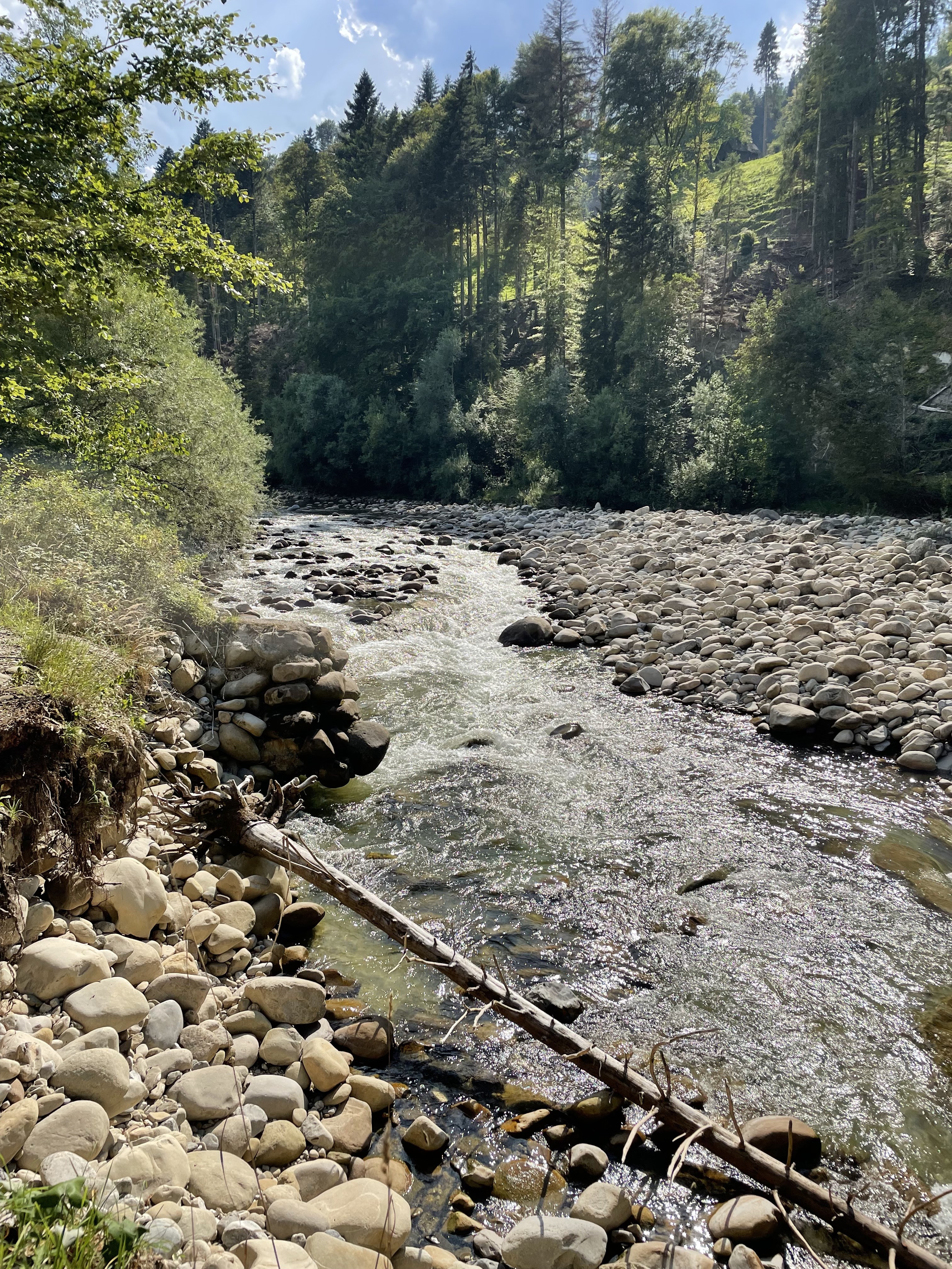
 Gefahr vorübergehend
Ufermauer unterspühlt 500m vor Emmenmättli, https://goo.gl/maps/w4cazPoiySLdrAXi9
 • #5435 • 16.08.2023 20:00
Hira (NO), Storfjellsætra - Hirkjolen
Info
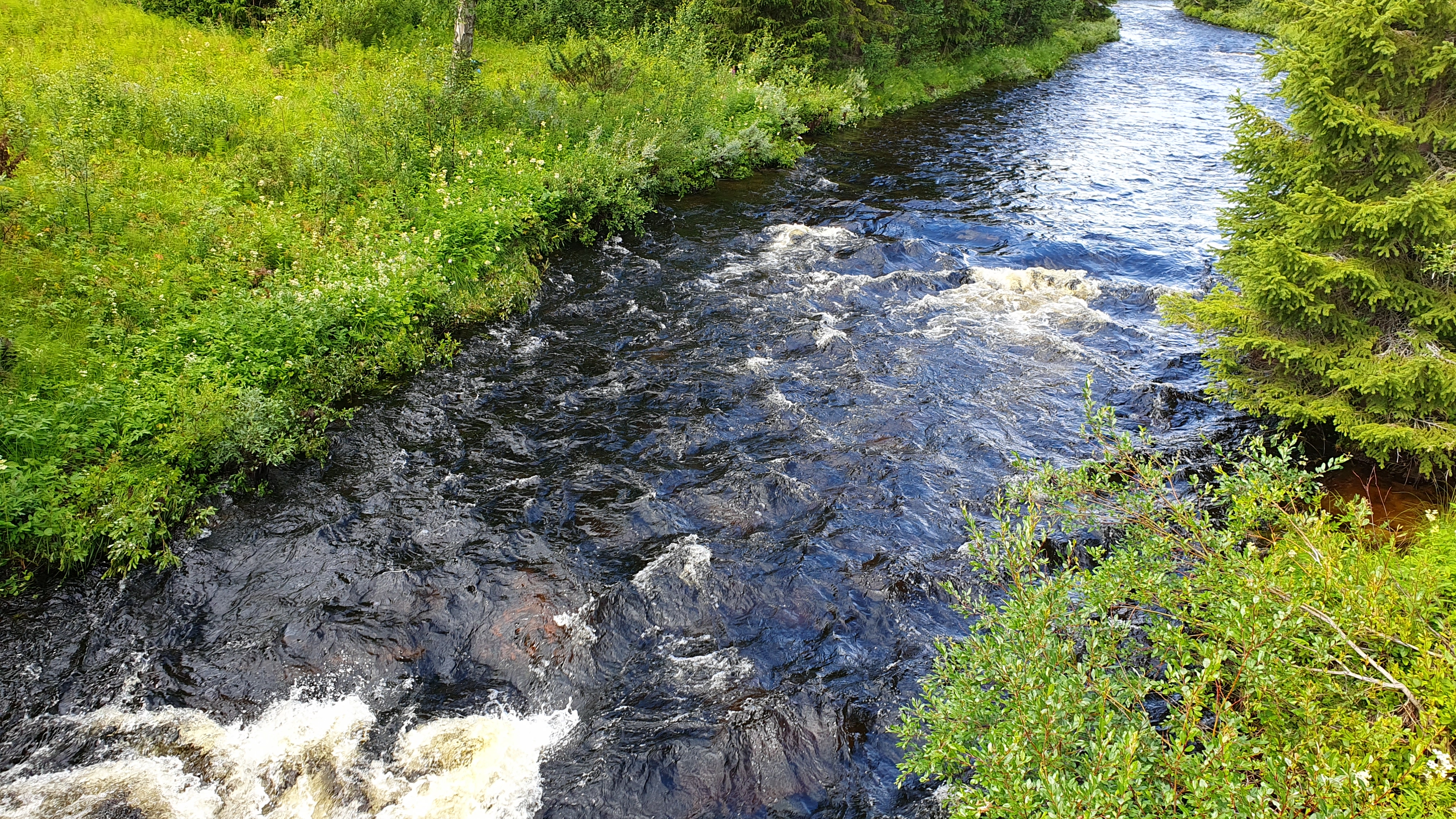
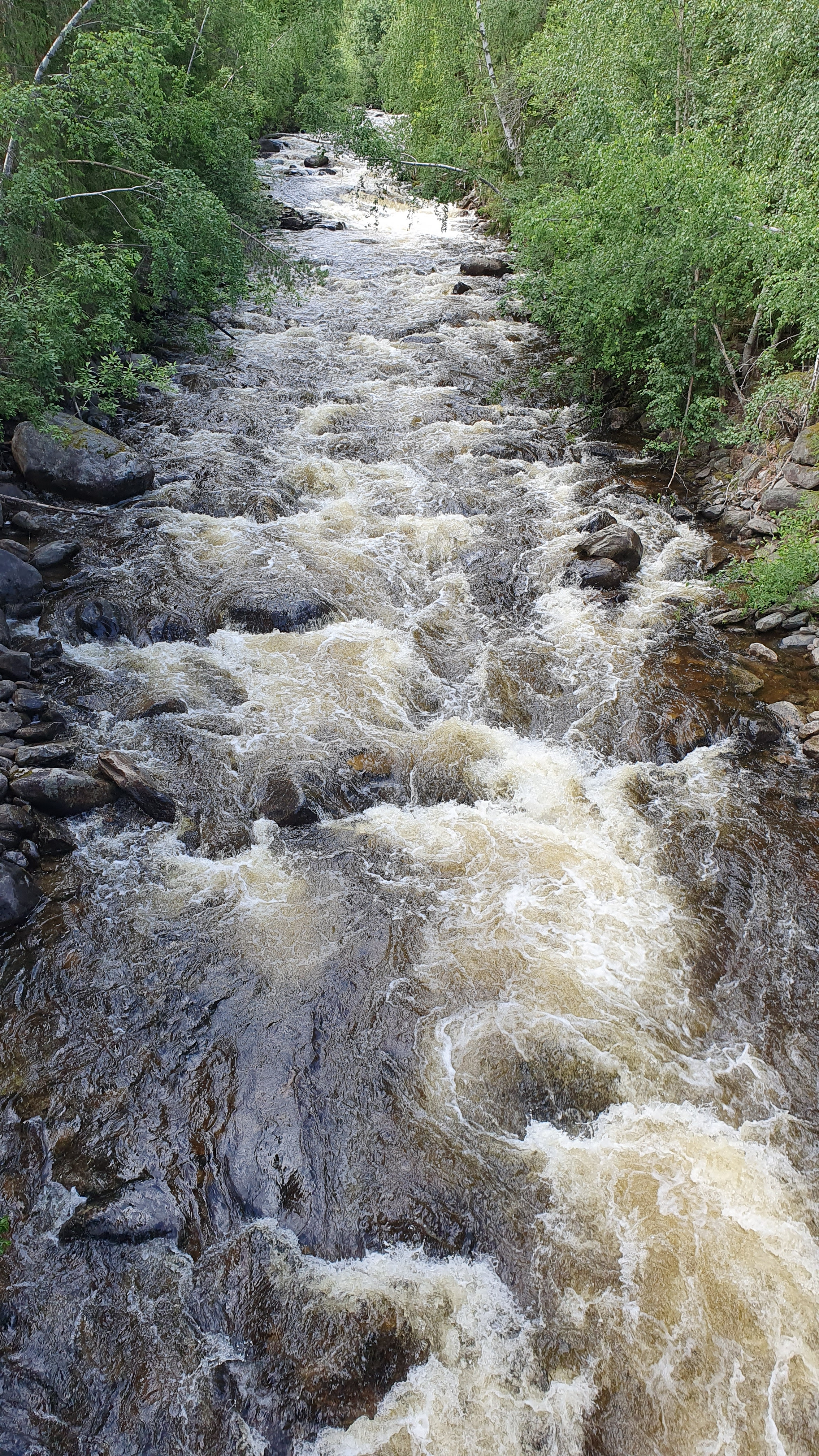
As the reference station is from Imsa, you have to take a look at the level locally. It should be around 10m3s (the upper section needs a bit less than the lower).
the following pictures show a good level at the takeout of the lower section and at the bridge of road E219.
the following pictures show a good level at the takeout of the lower section and at the bridge of road E219.
 • #5434 • 15.08.2023 13:10
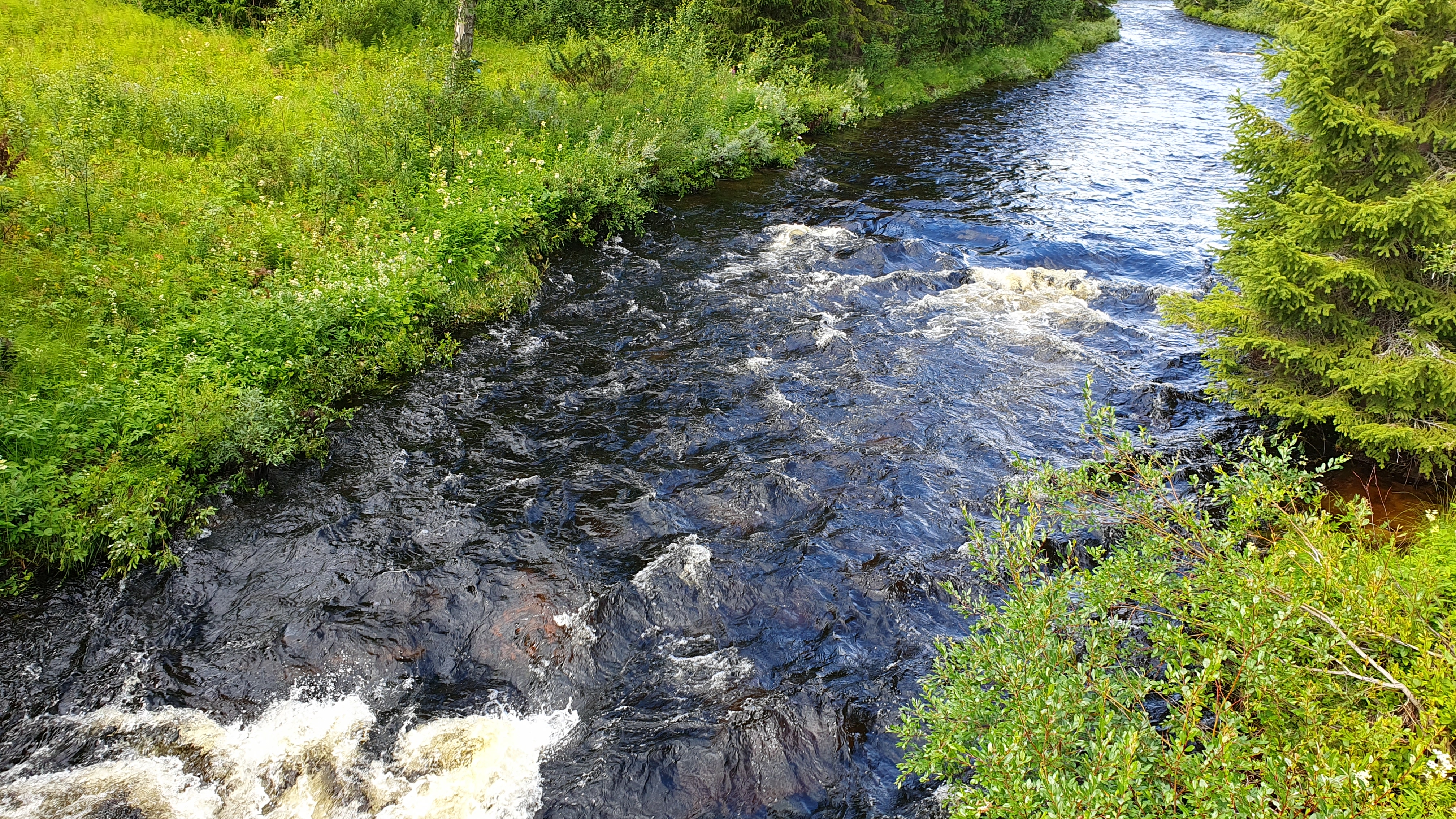
Hira (NO), Hirkjolen - Dammyra
Info
As the reference station is from Imsa, you have to take a look at the level locally. It should be around 10m3s (the upper section needs a bit less than the lower).
the following pictures show a good level at the takeout and at the bridge of road E219.
the following pictures show a good level at the takeout and at the bridge of road E219.
 • #5433 • 15.08.2023 13:08
Atna (NO), Lower (Trobrua - Mogrenda)
Info
• #5432 • 15.08.2023 12:55Hira (NO), Hirkjolen - Dammyra
Info
videos of this section and the section upstream:
https://www.youtube.com/watch?v=DCni2eqCsXk
https://www.youtube.com/watch?v=BSQsm35cxh0
https://www.youtube.com/watch?v=DCni2eqCsXk
https://www.youtube.com/watch?v=BSQsm35cxh0
• #5431 • 15.08.2023 12:55Hira (NO), Storfjellsætra - Hirkjolen
Info
the videos in the previous 2 notes show this section and the following section.
• #5430 • 15.08.2023 12:53Atna (NO), Lower (Atnabrua - Trobrua)
Info
the video in the previous note shows this section and the following section.
• #5429 • 15.08.2023 12:52Lammer (AT), Lammeröfen
Flash!
Boat was found today at the end of the Lammeröfen!
We are in the area until wednesday, hit me up if its yours:
+436602950886
We are in the area until wednesday, hit me up if its yours:
+436602950886
• #5428 • 14.08.2023 14:07Untertalbach (AT), Untertalbachklamm
Gefahr vorübergehendUnexpected lot of work at the Untertalbach ????
We just wanted to take care on the tree at the slot that we knew..
But seemed the storm hit pretty fast there. We cleand about 10 trees, but there are still few.
Actually 13.08.
❌️Right line after first rapid blocked
❌️Slot blocked (portage right possible but tough)
❌️Huge tree ar and of Silvercataract blocking 2/3
https://www.facebook.com/vboyzat/posts/pfbid02BWbQwQxPCGxQNpydKVav5em7ShcxPUoNdfCgvpmX6ZViECcMg1V8siXp2XubVgFGl
We just wanted to take care on the tree at the slot that we knew..
But seemed the storm hit pretty fast there. We cleand about 10 trees, but there are still few.
Actually 13.08.
❌️Right line after first rapid blocked
❌️Slot blocked (portage right possible but tough)
❌️Huge tree ar and of Silvercataract blocking 2/3
https://www.facebook.com/vboyzat/posts/pfbid02BWbQwQxPCGxQNpydKVav5em7ShcxPUoNdfCgvpmX6ZViECcMg1V8siXp2XubVgFGl
• #5427 • 14.08.2023 10:06Koppentraun (AT), Bad Aussee - Koppenrast
Bewertung NW-MW-HW
In Bad Aussee gibt es einen vielleicht objektiveren Online Pegel in qm/s: https://egov.stmk.gv.at/at.gv.stmk.hydavis-p/pub/praesentation/index.xhtml;jsessionid=O6zae7CTSDPxfRMtg5aqIphG?messcode=2002&ansichtstyp=karte&stationsstatus=%5Bonline%5D&dswid=2243&hdnr=ow0050
• #5426 • 13.08.2023 22:04Koppentraun (AT), Bad Aussee - Koppenrast
Bewertung NW-MW-HW
Der Pegel dürfte sich wieder verändert haben. 115cm 2023 entsprechen meinen Gefühl nach 125-130cm im Jahr 2022.
• #5425 • 12.08.2023 21:01Koppentraun (AT), Bad Aussee - Koppenrast
Gefahr vorübergehendIm zweiten Katarakt liegen nach der großen Walze rechts und in der Mitte gefährliche Bäume.
• #5424 • 12.08.2023 20:55Inn (CH), Scuoler Strecke
Flash!
Gefunden einstieg scuoler strecke, eine wasserdichte olympus Kamera. Befindet sich im Camping Scuol an der Reception.
• #5422 • 12.08.2023 14:53Gail (AT), Mittlere, St. Lorenzen - Birnbaum/Nostra
Befahrbarkeit
10.07.2023, 70 cm, befahren ab Brücke Klebas bis Kötschach - alles frei bis auf den überspülten Baumstamm, der seit mehreren Jahren liegt und überfahrbar ist. Flussbett teils ein bisschen verschoben.
• #5421 • 10.08.2023 18:40Smědá (CZ), Bílý potok
Befahrbarkeit
07.08.2023 No trees, everything ok
• #5420 • 07.08.2023 15:43Valepp (AT),
Befahrbarkeit
Befahrung am 05.08.2023 bei 101cm
Super lässiger Abschnitt. Am Einstieg ist neben dem Gasthaus ein Schranken, der sich öffnen lässt wenn man freundlich beim Wirt nachfrägt. Dann kann man zum offiziellen Einstieg fahren. Sonst ca. 30min tragen.
War alles Baumfrei. Haben das Wehr und die Erzherzog Johann Klause Umtragen. Im oberen drittel ist ein Katarakt den ich als WW4 bei diesem Wasserstand bewerten würde. Sonst so 3+
Baum war nur einer drinnen ganz am Anfang der gut einsehbar und umtragbar war.
Shutteln ist sehr Aufwendig (Shuttelbunny ist zu empfehlen)
Super lässiger Abschnitt. Am Einstieg ist neben dem Gasthaus ein Schranken, der sich öffnen lässt wenn man freundlich beim Wirt nachfrägt. Dann kann man zum offiziellen Einstieg fahren. Sonst ca. 30min tragen.
War alles Baumfrei. Haben das Wehr und die Erzherzog Johann Klause Umtragen. Im oberen drittel ist ein Katarakt den ich als WW4 bei diesem Wasserstand bewerten würde. Sonst so 3+
Baum war nur einer drinnen ganz am Anfang der gut einsehbar und umtragbar war.
Shutteln ist sehr Aufwendig (Shuttelbunny ist zu empfehlen)
• #5419 • 07.08.2023 09:18Seite: 1 2 3 4 5 . . . 83 84 85 86 87 88 89 . . . 285 286 287
nach oben