Rivermap
HomeThe Map
List View
Befahrbarkeit
English Summary
Karte Einbetten
Systemstatus
Kontakt und Team
Datenlieferanten
Contributor Agreement
The RCSD
Public licenses
Rivermap Japan
![]() "Rivermap Supporter" Group
"Rivermap Supporter" Group
Flusshinweise
Als Grundlage dient wenn immer möglich ein Flussführer.
Gyr: St.Antoine - Vallouise
IV+ 0 km
Resultate 1 - 10 von 10
Bewertung NW-MW-HW
60cm (level with the concrete ledge) on the stick gauge at the put-in bridge is a lower medium level. expect some bouncy rocks in the steeper sections.
 • #6759 • 16.07.2025 22:29
Befahrbarkeit
run on 8.7.25 at lower level. tree across whole river not far from put in, runnable at very right. might be dangerous at very low level.
in middle section where river splits into two arms some wood close to where arms rejoin, avoid middle.
in middle section where river splits into two arms some wood close to where arms rejoin, avoid middle.
• #6747 • 09.07.2025 22:27Befahrbarkeit
Run at medium level, all clear
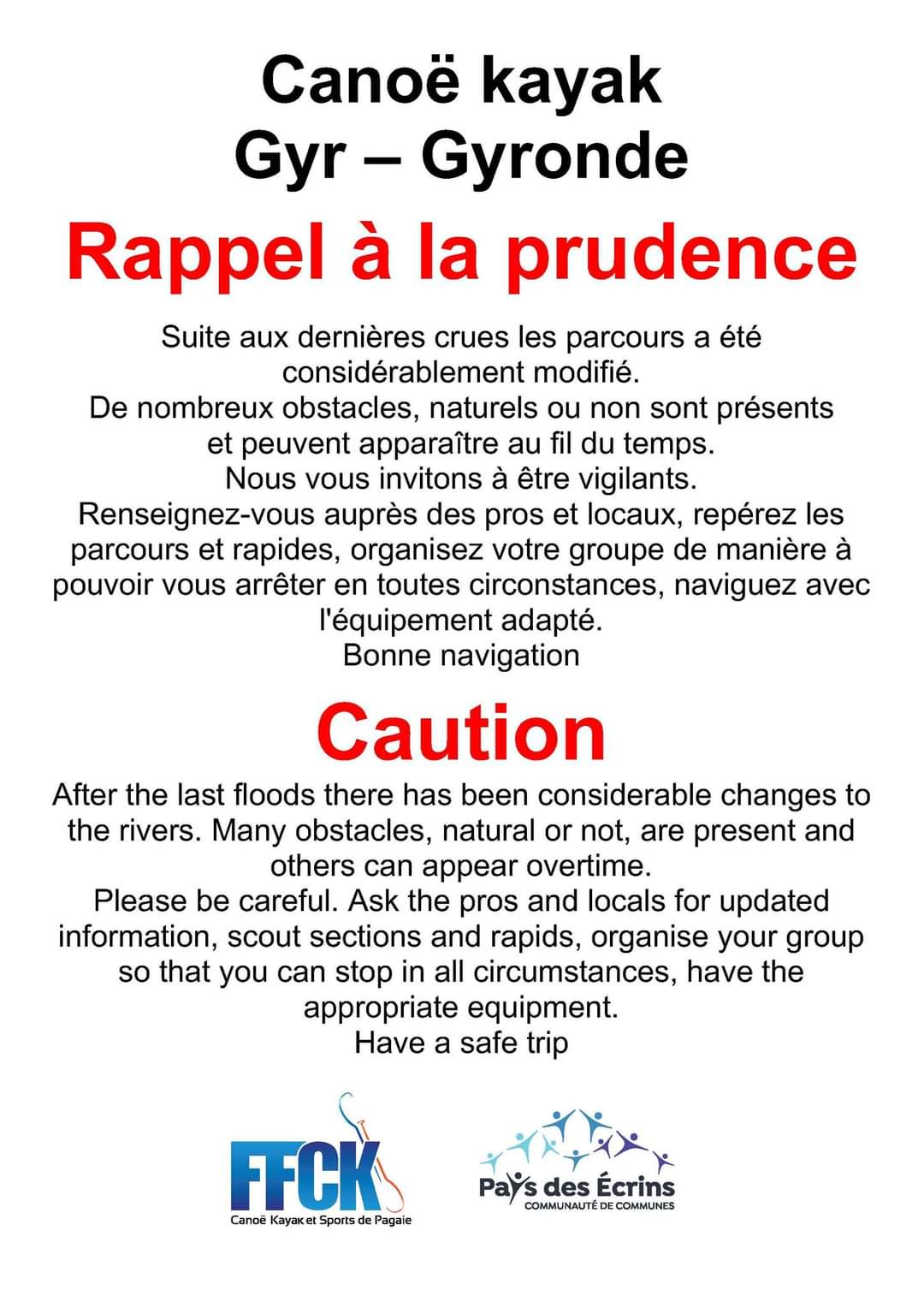
• #6590 • 28.05.2025 08:56The FFCK has issues an warning Saturday 6-7 due to the recent floods.
 • #6179 • 08.07.2024 11:33
Aktivismus
https://www.facebook.com/share/p/E4iQTDffeDWG6aR7/
https://www.facebook.com/share/p/yrpygdS6az7q2L8X/
We need HELP to save the last Free river section of "le Gyr", coming from the "Glacier Blanc" endangered by an micro hydroelectric power station project.
Please report any group of kayakers paddling the Gyr: Day, time, number of paddlers, to prove the use of the river by kayaking community, by posting at list one picture of the "put in", or any rapid, to compare observations to the power station project leaders.
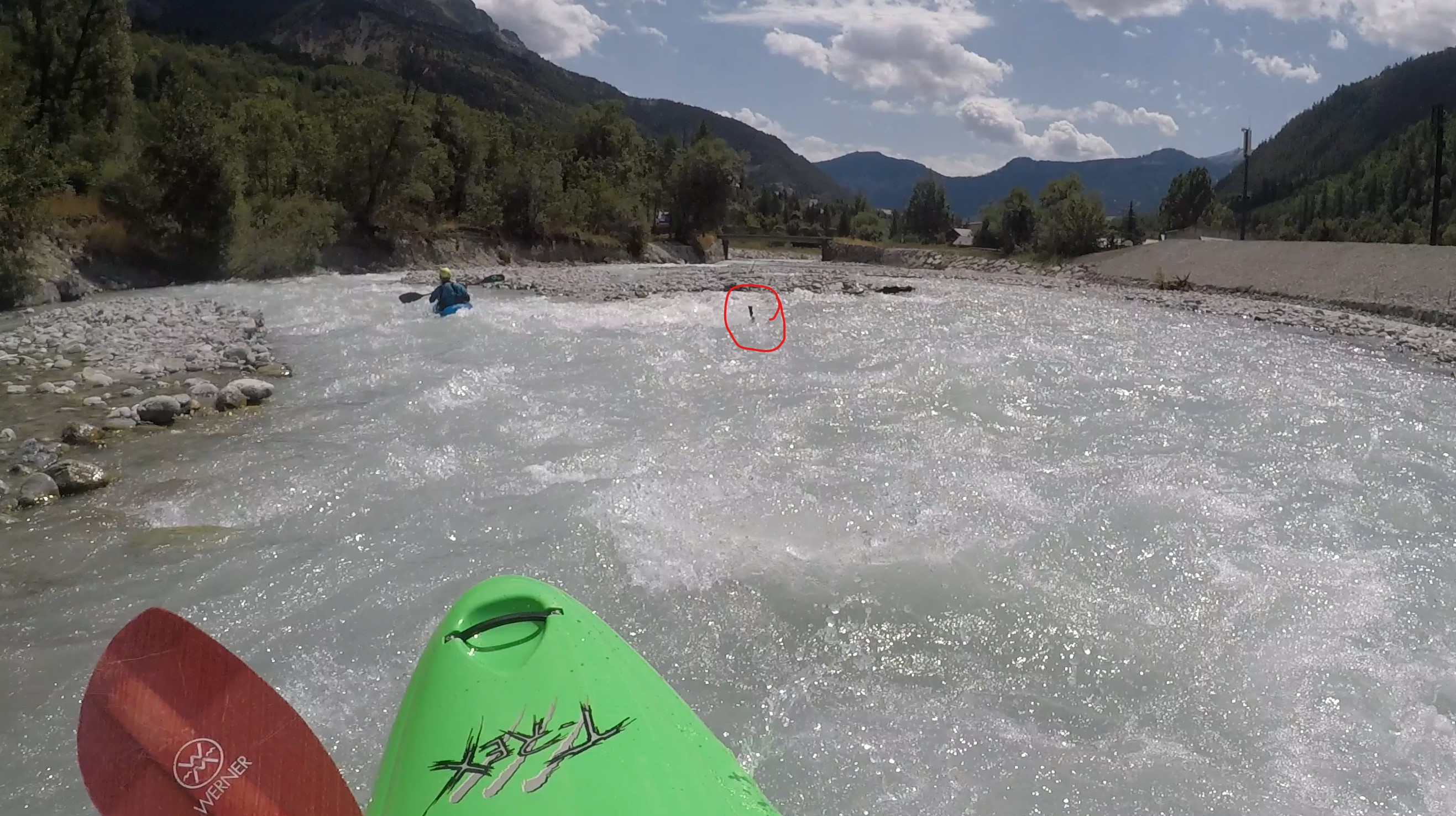
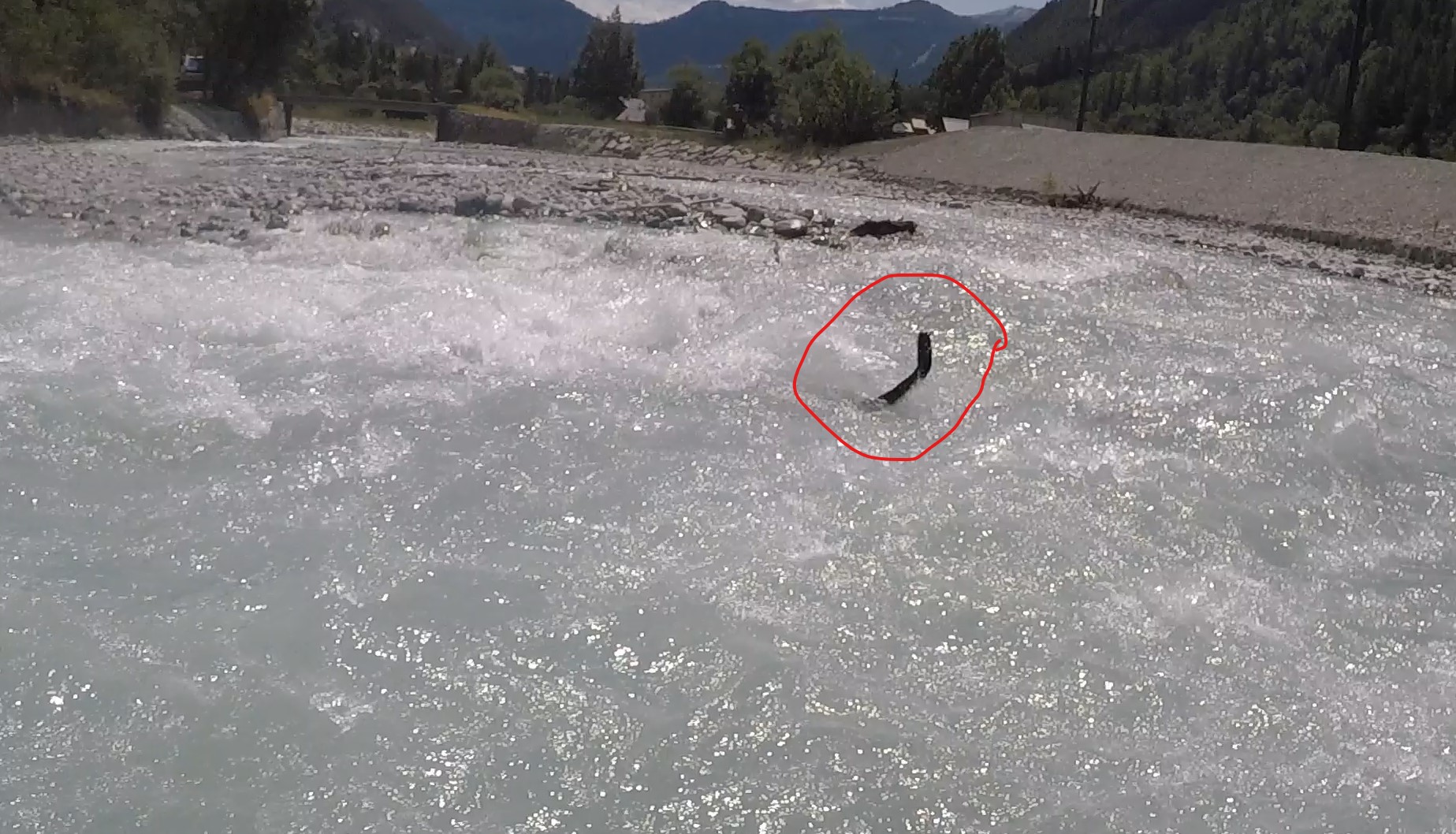
• #6163 • 03.07.2024 22:28Jagged steel bar jutting out of the gravel 100mt before the second bridge (approximate coordinates: 44.86705,6.48694)
 • #3544 • 14.08.2019 13:31
Befahrbarkeit
All clear
• #3527 • 08.08.2019 10:43Bewertung NW-MW-HW
Hilfspegel http://www.rdbrmc.com/hydroreel2/station.php?codestation=778
(Pegel bei Embrun)
Pegel geschätzt
NW = 55 m3/s
MW = 90 m3/s
HW = 150 m3/s
Pegel bei Einstiegsbrücke: 120cm = MW
Webcams: http://www.hautes-alpes.net/kayak-rafting/webcam-chateau-queyras.html
Manuelle Pegelangaben: http://www.bfk05.com/index.php?option=com_content&view=article&id=77&Itemid=28
(Pegel bei Embrun)
Pegel geschätzt
NW = 55 m3/s
MW = 90 m3/s
HW = 150 m3/s
Pegel bei Einstiegsbrücke: 120cm = MW
Webcams: http://www.hautes-alpes.net/kayak-rafting/webcam-chateau-queyras.html
Manuelle Pegelangaben: http://www.bfk05.com/index.php?option=com_content&view=article&id=77&Itemid=28
• #960 • 06.05.2012 11:01