Flusshinweise
Als Grundlage dient wenn immer möglich ein Flussführer.
Doubs: Refrain (Barrage - Usine Électrique)
IV (IV+) 0 km

Doubs @ En aval de Barrage du Refrain [estimé] -8.2 m³/s @ 22:00
10 | 25 | 80 m³/s (Indirect calibration!)
Resultate 1 - 20 von 29
Befahrbarkeit
1. Februar 2025. Direkt beim Einstieg liegt ein Baum im Bach... 40m weiter unten ist eine perfekte Einstiegsstelle.
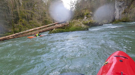
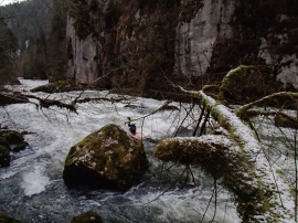
Ungefähr in der Mitte liegt nach einem flachen Teillstück ein Baum quer. Konnte bei 24m3 unterfahren werden - oder hinter dem rechten Auflagestein gesneakt werden.
Ungefähr in der Mitte liegt nach einem flachen Teillstück ein Baum quer. Konnte bei 24m3 unterfahren werden - oder hinter dem rechten Auflagestein gesneakt werden.
Bewertung NW-MW-HW
Change of estimation formula for the synthetic station:
New formula "La_Rasse - 23"
Old formula "(Noirmont*0.9) - 23"
Hopefully the calibration stays the same :)
New formula "La_Rasse - 23"
Old formula "(Noirmont*0.9) - 23"
Hopefully the calibration stays the same :)
Bewertung NW-MW-HW
The order (and naming) of things:
1. Le barrage du Châtelot (47.10114,6.74468), creating Lac de Moron.
2. Outfall from Châtelot powerstation returns to Doubs (47.12104,6.77325)
https://www.sfmc-sa.com/production
3. The Vigicrue river gauge @ La Rasse (47.15475,6.84322)
https://www.vigicrues.gouv.fr/station/U211201001
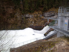
4. Le barrage du Refrain (47.17369,6.84602), creating Lac de Biaufond.
The water for the Refrain powerstation is taken from the lake.
http://massif-du-jura.developpement-edf.com/images/edf-1r1t-massif-jura-plaquette_doubs.pdf
- 23 cumecs max
- all the water is drawn from the lake
- 3 turbines
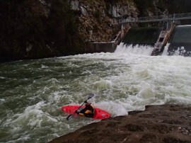
5. The ww section starts below the dam and ends before the powerstation outfall. The flow on the section is the dam overflow, which has to be estimated.
6. Outfall from the Refrain powerstation returns to Doubs (47.18842,6.87292).
Yesterday, 7.12.24, 35 Kubik. Good funny waterlevel.
Two trees! One is already a couble If weeks there. Paddel over it far left. The other tree is a big one. You HAVE to paddel to the right...water is pushing strong in to the Shit!
Two trees! One is already a couble If weeks there. Paddel over it far left. The other tree is a big one. You HAVE to paddel to the right...water is pushing strong in to the Shit!
Baum nach dem Drop, keine Durchfahrt bei 22cbm möglich, links umtragen. Momentan ne Menge Holz am Bach, aber alles gut sichtbar.
Baum in der Haupdurchfahrt rechts an der drittletzten markanten Stelle vor dem Ausstieg. Baum lässt sich bei ca 40m3 noch gut unterfahren. Vorsicht bei höherem Pegel
Baum aus #6514 nicht mehr dort. Dafür liegt ca 20 m weiter oben ein Baum quer über den ganzen Fluß. Bei 38 und 32 m3 ganz links überfahrbar. Vorsicht. Rechte Route geht da im Moment überhaupt nicht.
Ne Menge Holz im Bach, die Linien sind frei, trotzdem Vorsicht
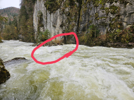
Holz in der ersten größeren Stelle
Wood in the first main Rapid
Pegel: ca. 100 Kubik
Wood in the first main Rapid
Pegel: ca. 100 Kubik
Befahrbarkeit
Kraftwerk scheint momentan in Revision. Es laufen z.Zt. ca 20m3 mehr über die Wehrkrone
Bäume im letzten Rapid vor dem E-Werk, können ganz links umfahren werden. Sind von der Strasse aus einsehbar.
Gefahr aufgehoben
Gefahren 01/10.
Baum gemäss #4688 liegt nicht mehr da.
Baum gemäss #4688 liegt nicht mehr da.
Baum in der letzen, schwierigen Stelle (kurz bevor die Strasse wieder parallel zum Fluss verläuft: Der Stamm liegt rechts im Bach, liess sich bei 39m3 links- und rechtsseitig umfahren.
Info
Winterliches Wildwasser. Per Mitte Januar 2021 keine Bäume im Bach, alles frei.
https://vimeo.com/504073487
https://vimeo.com/504073487
Bewertung NW-MW-HW
This graph is useful for thinking about what is happening to water levels.
https://riverzone.eu/station/compare/70019673-62cd-364c-96ee-0d45cf0d72c8.Q@976273cc-99bd-5e34-981c-796087563088.Q@3e33b032-1d49-55db-a095-0773085137ef.Q@31eecd8c-441b-34af-ba13-745416fd849f.Q
There is no gauge directly on the section.
La Rasse gauge is above the reservoir above the barrage (and the powerstation in-take) above the section.
Le Noirmont is currently the closest station below the section (and the powerstation out-fall).
Goumois is further downstream.
Info
The rapids in the bottom third of the section are easier but still fun. These can be used for a quick warm-up, or for short training laps, if the upper rapids are judged too difficult or consequential.
Bewertung NW-MW-HW
35 cumecs estimated. Nice class IV level.
Bewertung NW-MW-HW
Apparently there is an agreement that the Châtelot hydro station should only reduce flow at a maximum rate 2 cumecs/hr for ecological reasons.
Here is an interesting article, from before the regulation, describing the effects of sudden flow reduction. https://www.letemps.ch/barrage-maltraite-doubs
Here is an interesting article, from before the regulation, describing the effects of sudden flow reduction. https://www.letemps.ch/barrage-maltraite-doubs
Befahrbarkeit
am 4.3.2017 3x gefahren bei 58m3/s. Es hatte deutlich mehr Wasser als auf den Bildern von Eintrag 1825, obwohl dieser auch 58m3/s angibt. Ich nehme an, das Kraftwerk hat bei uns gerade weniger produziert.
Alles gut fahrbar und spassig. Es kann noch gut mehr vertragen. Bei 80-100m3 dürfte es ein guter Wuchwasserklassiker werden :-)
Alles gut fahrbar und spassig. Es kann noch gut mehr vertragen. Bei 80-100m3 dürfte es ein guter Wuchwasserklassiker werden :-)
Bewertung NW-MW-HW
Paddled with 40 m³/s on the BAFU Combe des Sarrasins gauge, dropping to 35 m³/s.
Nice quality class IV.
Nice quality class IV.
Befahrbarkeit
Bei 58 m3/s schöne wuchtige Strecke. Auf der linken Seite kann man aussteigen und alles anschauen. Links von der Strecke verläuft die Strasse, man kann jederzeit abbrechen.
Bewertung NW-MW-HW
Great volume section!!
Please use the Combe des Sarrasins scale.
NW= 30m3/s
MW= 45m3/s
HW= 60m3/s
I guess that the very good paddlers can run it with even more water than 60m3/s.
We ran it on the 9th of May 2015 with 55m3/s and it was a nice volume run. But it is not recommended to swim with this level (it gets complicated to catch a boat)!!
Info
http://www.eauxvives.org/fr/rivieres/voir/doubs/parcours:1441
P5, Parcours du Refrain:
Barrage du Refrain - l'usine éléctrique
P5, Parcours du Refrain:
Barrage du Refrain - l'usine éléctrique

