Rivermap
HomeThe Map
List View
Befahrbarkeit
English Summary
Karte Einbetten
Systemstatus
Kontakt und Team
Datenlieferanten
Contributor Agreement
The RCSD
Public licenses
Rivermap Japan
![]() "Rivermap Supporter" Group
"Rivermap Supporter" Group
Flusshinweise
Als Grundlage dient wenn immer möglich ein Flussführer.
Morača: Kanjon
II (IV-V) 0 km

Morača @ Pernica 78 cm @ 14.05.2026 12:00
? | ? cm
Resultate 1 - 4 von 4
Befahrbarkeit
Done at 28/5/2026 with 67cm at bridge level just before Mrtvica river. Amazing river more in spanish with maps, fotos and topoguides at https://blog.packrafting.cat/rio-moraca-packraft-montenegro Packrafting.cat: https://blog.ackrafting.cat
 • #7363 • 03.06.2026 14:14
Info
Wir sind diesen Abschnitt am 16.6.2025 bei starkem sommerlichem Niedrigwasser (Pegel Pernica: 34 cm) von der Mündung der Mrtvica 42.71917, 19.36771 bis zum Ausstieg vor der zweiten Hängebrücke 42.58666, 19.35893 gefahren. Bei diesem Wasserstand hat man vor allem zu Beginn öfter Steinkontakt. Trotzdem ist eine Befahrung ein absolutes Highlight und sehr empfehlenswert!
Nach 0,0 km 42.71917, 19.36771
Mit PKW gut erreichbarer Einstieg an der Mündung der Mrtvica. Der Parkplatz auf der Wiese gehört dem Besitzer von Camping Vesko schräg gegenüber. Wenn man auf dem Campingplatz war, kann man umsonst auf der Wiese parken, sonst verlangt er 3 € dafür.
Nach 1,4 km 42.70761, 19.37145
Links möglicher Einstieg auf Kiesbank
Nach 1,6 km 42.70650, 19.37389
Straßenbrücke
Nach 2,2 km 42.70332, 19.37723
Links Mündung der Sjevernica, rechts letzter möglicher Einstieg/Ausstieg vor dem Canyon
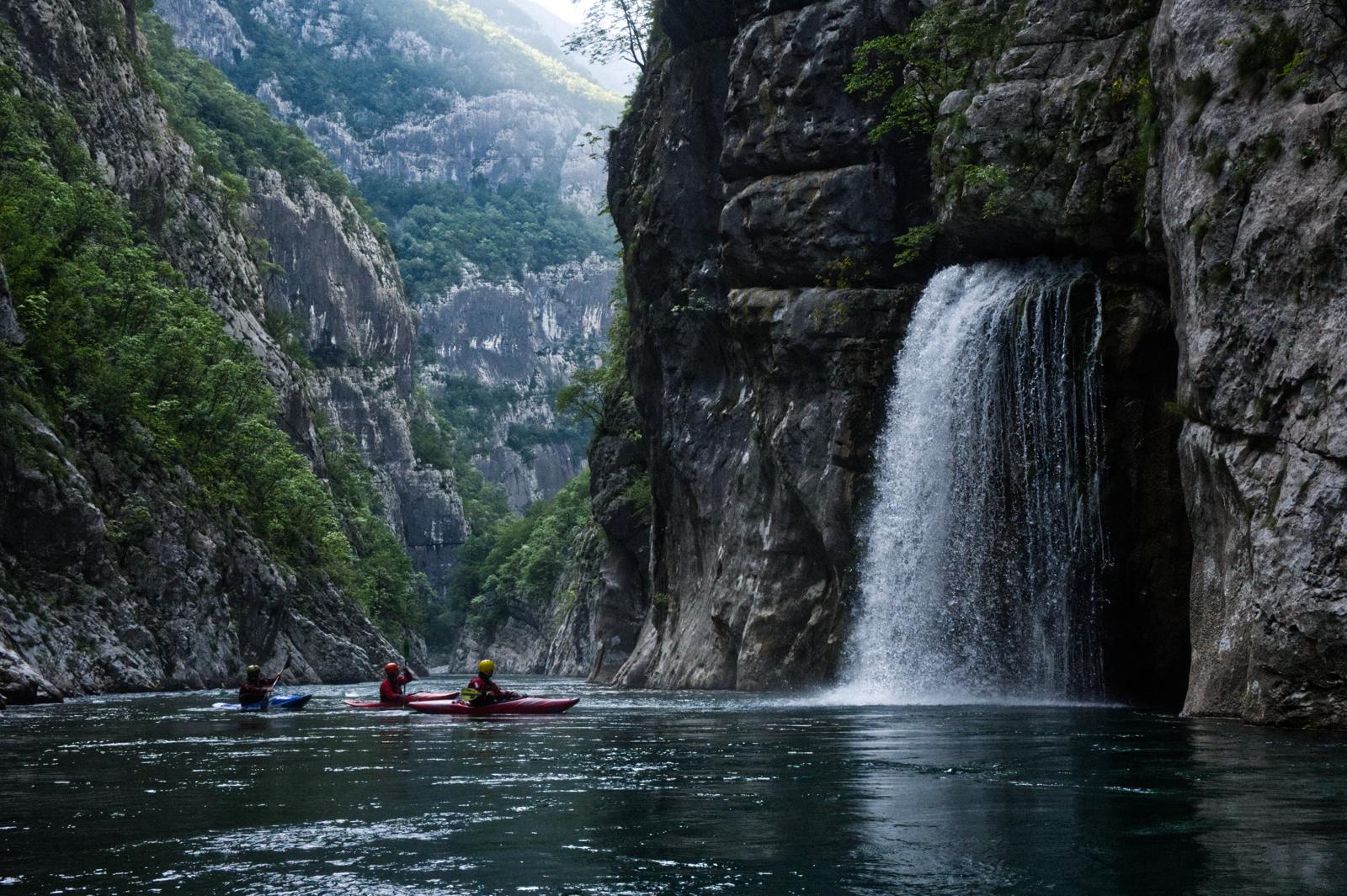
Nach 3,6 km 42.69176, 19.37499
Rechts stark schüttende Karstquelle in Form eines wunderschönen Wasserfalls
Nach 5,4 km 42.67678, 19.37173
Erste stark verblockte Stelle. Wir mussten hier umtragen, weil die Durchfahrten für ein Kajak zu eng waren.
Nach 5,7 km 42.67442, 19.36930
Zwangspassage, 100 m starke Verblockung, bei unserem Wasserstand maximal Wildwasser IV. Die Stelle kann vom Parkplatz am Tunneleingang aus besichtigt werden, wenn auch nur aus großer Höhe.
Nach 14,6 km 42.60209, 19.38022
Rechts möglicher Ausstieg
Nach 15,0 km 42.59949, 19.37835
Erste Hängebrücke, Ort Dromira
Nach 15,4 km 42.59785, 19.37374
Siphonstelle, rechts umtragbar, bei unserem Wasserstand rechts fahrbar
Nach 17,3 km 42.58666, 19.35893
Rechts Ausstieg an einer Kiesbank 200 m vor der zweiten Hängebrücke. Die Hängebrücke ist vom Ausstieg sichtbar.
Nach 0,0 km 42.71917, 19.36771
Mit PKW gut erreichbarer Einstieg an der Mündung der Mrtvica. Der Parkplatz auf der Wiese gehört dem Besitzer von Camping Vesko schräg gegenüber. Wenn man auf dem Campingplatz war, kann man umsonst auf der Wiese parken, sonst verlangt er 3 € dafür.
Nach 1,4 km 42.70761, 19.37145
Links möglicher Einstieg auf Kiesbank
Nach 1,6 km 42.70650, 19.37389
Straßenbrücke
Nach 2,2 km 42.70332, 19.37723
Links Mündung der Sjevernica, rechts letzter möglicher Einstieg/Ausstieg vor dem Canyon
Nach 3,6 km 42.69176, 19.37499
Rechts stark schüttende Karstquelle in Form eines wunderschönen Wasserfalls
Nach 5,4 km 42.67678, 19.37173
Erste stark verblockte Stelle. Wir mussten hier umtragen, weil die Durchfahrten für ein Kajak zu eng waren.
Nach 5,7 km 42.67442, 19.36930
Zwangspassage, 100 m starke Verblockung, bei unserem Wasserstand maximal Wildwasser IV. Die Stelle kann vom Parkplatz am Tunneleingang aus besichtigt werden, wenn auch nur aus großer Höhe.
Nach 14,6 km 42.60209, 19.38022
Rechts möglicher Ausstieg
Nach 15,0 km 42.59949, 19.37835
Erste Hängebrücke, Ort Dromira
Nach 15,4 km 42.59785, 19.37374
Siphonstelle, rechts umtragbar, bei unserem Wasserstand rechts fahrbar
Nach 17,3 km 42.58666, 19.35893
Rechts Ausstieg an einer Kiesbank 200 m vor der zweiten Hängebrücke. Die Hängebrücke ist vom Ausstieg sichtbar.
 • #6713 • 01.07.2025 15:25
Info
I paddled this section on April 12th 2025 at a level of 62cm. Everything was runable like last year. The main rapid becomes more technical and less pushy at this level. It can be scouted from the rocks at the top on the right. The first two bigger drops could even be portaged at this level. The rest of the rapid is still a must run.
 • #6496 • 23.04.2025 20:43
Info
I paddled this section on April 13-th 2024 at a level of 75 cm. We put in at 42.703611,19.376722 at the confluence with the Sievernica river, where there is an easy access to the road above. The section is mostly WW 2 with some class 3 rapids. However the rapid in the Platjie canyon at 42.674361,19.369028 is class 4-5 depending on water levels. It is boxed in between vertical walls and cannot be portaged. Scout from the road above and from the big rocks at the entry to the rapid. The line is from the middle left to the right over the first drop into the eddy river right. Scout again from the rocks if necessary. From there, stay center dropping over the rock in the middle and then choose either left or right. We took out at 42.586528,19.358833 , where the road is easily accessible.
 • #5821 • 18.04.2024 21:53