Flusshinweise
Als Grundlage dient wenn immer möglich ein Flussführer.
Ödenseetraun
III 0 km

Traun @ Obertraun 106 cm @ 15:45
120 | 140 | 160 cm (Indirect calibration!)
Resultate 1 - 2 von 2
We paddled this section today, thinking it might be a nice high water alternative to Koppentraun (and also easier than Koppentraun).
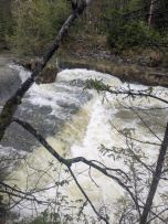
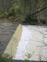
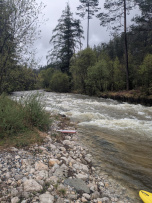
The water level in Koppentraun was around 145 cm and can be seen in the pictures attached (there's one from the takeout as well).
We had seen the artificial dams of this section in the video posted here in the comments as well, however:
! At this waterlevel, the backwash is very powerful and dangerous!
! It is really difficult to stop and get out to scout / portage because the Eddies are small and sparse (especially near the dams)!
! There are 3 dangerous dams in total, which follow in quick succession, starting with the one with the rock (First picture)!
Be very careful when you run this. Especially if your usual comfort level is WW3. In general, we would not recommend to paddle this and suggest to find sth else instead.
Shuttle can be done with the train, if you don't mind some walking. Don't paddle further than takeout. There' s another danergius old dam.


